Prospect (avenida) del Libertador is one of the main streets of the northern part of the city of Buenos Aires , Argentina . Del Libertador is the main highway to the municipalities of Vicente Lopez, San Isidro and San Fernando. Starting in the vicinity of the Retiro district, it ends after about 35 km of travel on the edge of the province of Buenos Aires between the municipalities of Tigre and San Fernando. The avenue was named after General Jose de San Martin , the hero of the war of independence of Argentina, Chile and Peru.
| Avenida del Libertador | |
|---|---|
Spanish Avenida del libertador Buenos Aires | |
 | |
| general information | |
| A country | |
| Area | Retiro , Recoleta , Palermo , Belgrano , Nunez , |
| Underground | |
| Bus routes | 5, 7, 9, 15, 17, 23, 26, 28, 29, 33, 34, 37, 42, 45, 56, 60, 61, 62, 64, 67, 91, 92, 93, 101, 102, 107, 110, 115, 124, 130, 132, 152, 160, 166, 168, 195 (collectively) |
 | |
Traveling the Street
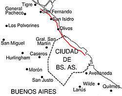
The avenue begins on Avenida Leandro N. Alem . Then it continues parallel to the Rio de la Plata through the vicinity of the Recoleta, Palermo, Belgrano and Nunez districts. Crosses Avenida General Pas perpendicularly and passes in the northern suburbs of Buenos Aires, crossing the municipalities of Vicente Lopez, San Isidro and San Fernando. While the name of the avenue does not take all the way, numbering depends on the area: in Buenos Aires, houses are numbered from 1 to 8700, in the municipality of Vicente Lopez 1 to 4200, in the municipality of San Isidro from 12900-18300, and the municipality of San Fernando 3900 -one. It is part of the 195 National Highway. National Decree No. 1595 of 1979 [1] prescribed that the section from Avenida General Paz to the municipality of San Fernando (14.5 km) fall within the jurisdiction of the province of Buenos Aires. Currently, highway 27 [2] [3] is part of the province.
History
Starting from the colonial era, that is, until 1810, this area was north of the central part of the city of Buenos Aires, between the cliffs and the coast of Rio de la Plata, a road called “Lower” or “Cañitas” (from the reeds growing on the natural shores of Rio de la Plata). This road served as a border, starting in 1580, when Juan de Garay distributed land outside the urban area north and south of Buenos Aires. The current Avenida De los Constituyentes and Avenida Fondo de la Legua avenues went northwest, while the road passing through the Rio de la Plata was called the Camino de Santa Fe or Low Road, now here the current Avenida del Libertador avenues, Arenales street, Avenida Las Heras, Avenida Santa Fe , Avenida Luis Maria Campos are located and here is the current Ferrocarril Miter railway line going to the municipalities of Tigre and San Fernando How the Avenida del Libertador street was created 1950, by decree of President Juan Domingo Peron in honor of the centenary of the death General José de San Martín, in order to create an avenue that runs through the entire northern part of Buenos Aires, several streets have been combined, from the Retiro district to the Nunez district, in the province of Avenida del Libertador, stretching from Avenida General Paz to San Fernando.
Paseo de Julio
Main article: Paseo de Julio
Also: Avenida Leandro N. Alem
The Avenida del Libertador section from San Martin to Plaza Butler was part of Avenida Leandro N. Alem, formerly called Paseo de Julio. Paseo de Julio was created around 1780 by Juan José de Vertic, as the first public promenade of Buenos Aires, facing Rio de la Plata. In 1846, during the reign of Juan Manuel de Rosas, the development of the coast and the construction of the wall began, in order to avoid floods of the river, due to which the Paseo de Julio began to expand in the following decades. In 1919, a city government decree changed its name to Avenida Leandro N. Alem, given to the street in honor of the revolutionary leader and founder of the Radical Civil Union party.
Avenida Alvear
The part of the street that starts from Piazza Alvear and ends on Avenida Dorrego was part of Avenida Alvear, named the city decree in 1893 in honor of Carlos Maria de Alvear . This street, formerly known as Bella Vista, ended at the Pilar Church and was extended in the 1860s to reach the Hipodromo Argentino, which became the Tres de Febrero Park , opened in 1875.
Avenida Virrey Vertis
The section of the street that begins on Avenida Intendante Bullrich Avenue and ends with the del Libertador Tunnel is the former section of Avenida Virrei Vertis, which became the section of Avenida del Libertador Avenue, to the corner of Avenida Virrei Vertis and Avenida Juramento. This section of the street was originally an independent street in connection with the creation of the city of Belgrano in 1860, and originally had the name Belgrano. When the city of Belgrano was incorporated into Buenos Aires in 1880, the street was named Avenida Virrei Vertis.
Blandengues Street
The section from the Del Libertador Tunnel to Avenida General Paz Avenue was previously called Blandengues between 1893 and 1942, and then General José Felix Uriburu Street until 1950. This stretch of street was narrow between La Pampa and Monroe. Between the 60s and 70s, they began to expand it and build a tunnel under the railroad tracks of the Ferrocarril Miter railway. One of the buildings most affected by this was the Instituto Santa Ana Institute, which lost 60 percent of its territory, and part of the garden [4] . With the advent of Avenida del Libertador Avenue, Blandengues Street actually entered the Barracas area.
Province
The provincial part of Avenida del Libertador, also corresponds to the aforementioned "Camino del Bajo". Since the 30s, this road has been transformed into National Highway 195, 14.5 km long, connecting Avenida General Paz and San Fernando, on the border between the municipalities of San Fernando and Tigre. Since 1988, it has been changed, its name is Provincial Route 195 and today is part of Highway No. 27 from Avenida General Paz to Benavides. In the municipality of Vicente Lopez, since 1913 the road bore the name Avenida José Camilo Paz, and from May 24, 1932 it was named General José Felix Uriburu and extended to Avenida Corrientes. Finally, in 1950, it was decided that Avenida José Felix Uribru and Avenida José Camilo Paz became part of Avenida del Libertador. In the municipality of San Isidro, Avenida del Libertador becomes a narrow, cobbled street with narrow sidewalks. Here it passes next to the cathedral and Plaza Miter, through the historic center of the town. Further north, Avenida del Libertador reappears, already much narrower, and goes to the center of San Fernando.
Attractions
Avenida del Libertador begins at the intersection of Leandro N. Alem Avenue and Avenida San Martín, where San Martín Square is located. Five blocks away, Nueve de Julio passes by Avenida and is close to Recoleta Cemetery and the National Museum of Fine Arts. In the Palermo area the most famous are: Monument to the Spaniards , Park Tres de Febrero , Zoo, exhibitions of real estate and agriculture of Argentina and the Palermo Hippodrome. Continuing north, in the vicinity of the Belgrano district (in particular, Baho Belgrano), the street passes under the railway tracks in Bartolome Miter through the “Tunnel” del Libertador, about 700 meters long. At the end of the tunnel along La Pampa is a sports club. Walking to the neighborhood of Nunez, just a few blocks from the street, is the River Plate Sports Club.
Retiro
Railway station Retiro
San Martin Square
Torre Monumental
Prourban
Patio bullrich
Recoleta
Museo nacional de bellas artes
National Library
Argentine Automobile Club
Museo nacional de arte decorativo
Palermo
Monument to the Spaniards
Park Tres de Febrero
Palacio bosch
Argentine Racecourse
Nunez
SHMVA
National Atomic Energy Agency
Notes
- ↑ Decreto Nacional 1595/79 con comentarios . (inaccessible link)
- ↑ Texto de la Ley 10.656 de la Provincia de Buenos Aires , publicado en el Boletín Oficial el 7 de septiembre de 1988
- ↑ Nuestras Rutas - Vialidad de la Provincia de Buenos Aires
- ↑ Revista Panorama (1970), [1]