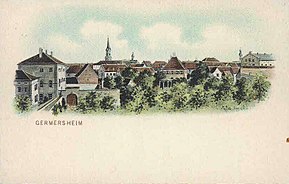
Germersheim ( German: Germersheim ) is a city in Germany , a regional center, located in Rhineland-Palatinate .
| City | |||||
| Germersheim | |||||
|---|---|---|---|---|---|
| Gersmersheim | |||||
 Germersheim | |||||
| |||||
| A country | |||||
| Land | Rhineland-Palatinate | ||||
| Area | Germersheim (area) | ||||
| Internal division | 2 urban areas | ||||
| Burgomaster | Marcus Schaile ( CDU ) | ||||
| History and Geography | |||||
| Square | 21.40 km² | ||||
| Center height | 105 m | ||||
| Timezone | UTC + 1 , in summer UTC + 2 | ||||
| Population | |||||
| Population | 20,588 people ( 2010 ) | ||||
| Digital identifiers | |||||
| Telephone code | +49 7274 | ||||
| Postcode | 76726 | ||||
| Car code | Ger | ||||
| Official code | 07 3 34 007 | ||||
| germersheim.de (German) | |||||

It is part of the Germersheim district . The population is 20,588 people (as of December 31, 2010). [1] Covers an area of 21.40 km². The official code is 07 3 34 007 .
The city is divided into 2 urban areas: it is the city of Germersheim and located south of Sondernheim , included in the city in 1972.

Content
Geography
Geographical location
The city is located on the left bank of the Rhine in the Upper Rhine Lowlands between the cities of Ludwigshafen , Mannheim and Worth on the Rhine , 15 km away. from Speyer . On the other side of the Rhine is the city of Philippsburg .
Climate
The climate, as well as throughout the Upper Rhine Lowland , is relatively mild: it is warm in summer and almost no snow in winter. The average annual temperature is 9 degrees. Since the city is located almost in the middle of the Upper Rhine Lowland , it rarely rains here.
History
Antiquity
At the time of the capture of Gaul by Julius Caesar , tribes and vangions lived on the territory of the region. After the capture, the province of Germania Superior was the border between the Roman Empire and the Germanic tribes. Later, even small territories east of the Rhine were captured and annexed to the province of Agri decumates ("Decumatian fields"). As a result of oppression by the Frankish and Aleman tribes in 275/276. the border was pushed to the Rhine towards the limes . On the site of the modern city, the Romans founded the fortified military camp Vicus Julius to guard the border. It lasted until the 4th century. After the Eastern Goths invaded Italy in 405, Roman soldiers were forced to leave the Palatinate.
Middle Ages
King Konrad II ordered the construction of a fortress and a castle on the banks of the Rhine in the area of modern Germersheim. The name of the city is mentioned in chronicles for the first time in 1090 as “Germaresheim”, but the status of the city was assigned to it only in 1276 by King Rudolph I. This event greatly influenced the history of the city.
Already in 1325 the city was given on bail to Kurpfalz by King Ludwig IV , and in 1329 Count Rudolph II annexed it to his subject territory.
New time
As a result of the plague , the Thirty Years War, and other catastrophes of the late Middle Ages and the beginning of a new time, the population of the city was reduced to several families. The city suffered even greater destruction during the Franco-Dutch war , when the French castle, built on the orders of Conrad II, was destroyed by French troops under the command of Conrad II. Only the crypt and foundation walls of the Catholic Church survived the fire. In 1699, the Franciscans settled in Germersheim and remained there until 1793.
On July 5, 1793, a battle took place near Germersheim in the framework of the revolutionary war . Then the French army was defeated by Austrian troops under the direction of Field Marshal Dagobert Sigmund von Wurmser , which accelerated the lifting of the siege of Mainz .
In the period from 1793 to 1814. Germersheim belonged to France . After the French occupation ended, it was decided to build a fortification in Germersheim to repel attacks from the French side. A plan for such a construction already existed during the Palatinate Succession War , but was rejected. The construction of the fortification began in 1831. Around the city were dug kilometers of excavations, which can be found today. In 1855, the construction of the fortification itself was completed, but the construction of mine galleries was delayed until 1861. When they were finished, it turned out that the fortification was outdated, because when planning it, no one counted on such a rapid development of the range and penetration ability of the guns. It turned out that fortification hindered the development of the city: it was impossible to build houses and factories outside its walls, and the area inside was limited. Thus, Germersheim simply turned into a garrison city, where the 17th Orff Infantry Regiment was located before the First World War .
In the years 1921-1922. according to the Treaty of Versailles, the fortification was liquidated, only small fortifications remained. Before the withdrawal from Germany of the troops of the victorious countries of the First World War in 1931, French troops were in Germersheim.
In 1936 the city again became a garrison. During World War II, the Wehrmacht Penal Battalion 999 was partially located in Germersheim. Lieutenant General Hans von Schponek , who had retreated from Hitler’s order in the winter of 1941, ordered his hopelessly inferior troops to retreat. After an unsuccessful attempt on Hitler in 1944, in which he did not take part, Shponek was shot.
After the war ended, American troops, then German troops, were still stationed in the city. There were 5 Bundeswehr barracks in the city, in 4 of them ground forces were located. In the barracks built in 1965 to them. Hans von Sponeck was air force battalions. Today in Germersheim is the training regiment of the German Air Force.
After the termination of the Warsaw Pact, American and German troops underwent a significant reduction throughout Germany, including in Germersheim.
Religion
In 1556, as a result of the Reformation , a Catholic monastery was closed in the city, and the church passed into the hands of the Lutherans, and only in 1697 - back to the Catholics. Since then, the city has been inhabited mainly by the Catholic population. After a wave of emigration in the 70s. the importance of other faiths, such as Protestantism and Islam, increased.
Population
- 1925 - 3308 (without Sondernheim)
- 1933 - 3735 (without Sondernheim)
- 1939 - 5858 (without Sondernheim)
- 1994 - 15 876 (without Sondernheim)
- 1998 - 20 210
- 1999 - 20,200
- 2000 - 20 134
- 2001 - 20 506
- 2002 - 20,542
- 2003 - 20 748
- 2004 - 20,906
- 2005 - 21,534
- 2006 - 22,340
Education
The city has the Faculty of Translation Studies, Applied Linguistics and Cultural Studies (Fachbereich Translations-, Sprach- und Kulturwissenschaft) of the Johannes Gutenberg University of Mainz , the largest training center for professional translators from many languages of the world, created in 1947 and received its current name in 1992 (see: [ 1] ). Birgit Menzel , Mikhail Bezrodny and others teach here.
Policy
Mayor
The burgomaster of the city is currently Dieter Hanlayn, who was elected to this position on September 23, 2001.
Former burgomasters:
- from 1956 to 1981: Siegfried Janzer
- 1981 to 2001: Banno Hyter
Coat of Arms
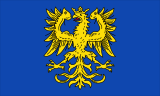
The emblem of the city depicts a golden imperial eagle on a blue background, which symbolizes giving the city in 1276 Rudolph I the status of a free imperial city .
Famous Natives and Residents
- Seidel, Max - Lawyer and Writer
- Zapp Robert Richard - Naval Officer
- Shponek, Hans von - military figure
Twin Cities
- Tournus ( France ) - since 1963
- Zalascentgroth ( Hungary ) - since 2005
Photos
Railway station
The shore of the Rhine.
Fortifications.
The building of financial management.
Notes
- ↑ Statistisches Landesamt Rheinland-Pfalz - Bevölkerung der Gemeinden am 31. Dezember 2010 Archived January 31, 2012. (PDF; 727 KB)