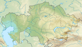
The Kazakh low mountains ( Sary-Arka , Central Kazakhstan low mountains, Kazakhs . Sary Arқa - “yellow ridge”) - steppe in central Kazakhstan , with small, steep lowland massifs (hence the name “low hills,” that is, small hills). In the west, the low-hills are limited by the Turgai hollow , in the northeast by the Irtysh valley, in the north by the West Siberian Plain , in the south-west by the Turan lowland . The length from west to east is 1200 km, the width in the west is 900 km and in the east is 400 km. In the center are the Karkaraly Mountains (1403 m). To the south is the Kyzyltas massif with the Aksoran mountain with a maximum height of 1565 m (the highest point of the small hills). In the south-west of the Ulytau mountain (1133 m). In the north, the Kokchetav Upland (947 m) is isolated. In the east, the ranges of Chingiztau (1077 m), Akshatau (1305 m). In the outskirts, isolated, rather high arrays of small (15-30 km) size are scattered - Bayanaul (1026 m), Degelen (1084 m), Zhaksy-Zhalgyztau (729 m), Burabay (947 m), Niyaz (833 m) and others Bektau-Ata massif (1213 m) is located in the southern part of the small hills, 70 km from Balkhash .
| Kazakh low mountains | |
|---|---|
| kaz Sary Arқa | |
 Landscape | |
| Highest point | |
| Highest peak | Aksoran |
| Highest point | 1565 [1] m |
| Location | |
| A country |
|
Two reserves , located on the territory of the Kazakh small mountains - Korgalzhynsky and Naurzumsky - are a UNESCO World Heritage Site .

Hydrology
Kazakh low-hill crosses many non-navigable rivers.
The major rivers are the Ishim (the Irtysh basin), the Nura , the Sarysu , the Silesti, the Shiderty, the Tokirau. They feed mainly on spring snowmelt, partly on groundwater. In the flood, they overflow from their banks and flood the floodplain. In the summer months, the rivers become shallow, turning into stretches and old women, often their beds dry up. Constant flow is observed only on Ishim . To provide fresh water to this region, the Irtysh-Karaganda canal was built. There are many salt lakes in the small mountains. Freshwater lakes are located mainly in the region of the Kokchetav Upland - Borovoye, Shchuchye, Bol'shoye Chebachye, Imantau and others (the so-called Borovoye Lakes ).
Climate
Since the Kazakh lowland is located at a distance from the oceans and seas, the Siberian anticyclone and the Arctic air masses freely circulate here. Therefore, the climate here is dry and sharply continental. The winter is cold, the average January temperature is –14 ° C –18 ° C, the minimum is –46 ° –48 ° C Summer is dry, hot, the average July temperature is + 20 ° С + 24 ° С, maximum up to + 42 ° С. The average annual rainfall is 200–300 mm in the southern part, 300–400 mm in the north. More than 370 mm of precipitation falls in mountainous areas of the mountainous area, and up to 480 mm on the northern and western slopes of the Kokchetav Upland.
Relief and geology
The Kazakh low-hilltop is a very ancient, heavily destroyed mountainous area, consists of flattened elevations and low-mountain low mountains. Between them are leveled areas, large and small depressions, depressions, differing in geological structure and relief. The eastern part of the upland is elevated in comparison with the western. The lowland is formed from sedimentary and igneous rocks (granite, porphyrite, quartzite, sandstone and shale) of the Paleozoic. In the formation of the relief of a small hill, the main role played by the direction of occurrence of rocks and weathering processes. Wind, rain, flowing waters destroyed the once high mountains and almost turned them into plains. In the central part of the mountainous area on the northern slopes grow pine forests, the southern slopes are bare and rocky. At the foot of the mountains there are clusters of rock fragments (talus). In the western part of the upland, flattened and lowered areas predominate, and the remnant mountains and hills are less common. Ancient sedimentary and igneous rocks of the early Paleozoic are visible here only on high rocky ridges. On the plains and in the depressions they are buried under the lake and sea sediments of the Paleogene. The formation of the relief of this part of the Kazakh small hills along with the long process of weathering was also influenced by the sedimentary rocks of the Cretaceous and Paleogene periods. The large basin, the Tengiz-Kurgaldzhinskaya Depression (304 m), divides the western part of the upland into two parts.
Gallery
Kokchetav Upland
Karkaraly Mountains
Bektau-Ata
Bayanaul Peak of the Brave
Notes
Links
- Yereymentau (mountains)
- Sary-Arka Mountains
- Kazakh low mountains