Embankment Street - a street in the center of Simferopol , passing along both banks of the Salgir River . After crossing the street Schmidt goes into the street Gasprinsky.
| Embankment street | |
|---|---|
 View of the Salgir River | |
| general information | |
| A country | Russia / Ukraine [1] |
| City | Simferopol |
| Area | central District |
| Length | 1 km |
The riverbed is lined with cement slabs with a cast-iron parapet and lamps. Along the river there are paths lined with trees, shrubs and flowers [2] .
Until 1897, the Salgir River was the boundary of the city limits [3] . On October 25, 1902, the city council decided to name "the street running along the shore of Salgir, Naberezhnaya Street" [2] .
In 1982, the name “named after the 60th anniversary of the USSR” was added to the name “Embankment”, and later its last part - from school No. 24 to ul. Schmidt - was called Ismail Gasprinsky Street [3] .
As of 1983, a number of enterprises and institutions for lighting the Crimea and the city of Simferopol were located on the embankment (Krymenergosbyt, its Simferopol branch, city light, Simferopol electric networks enterprise), the region’s gasification department, construction department No. 53 of the Simferopolpromstroy trust, Crimean branch Ukrsovkhozproekt Institute, Crimean Branch of the Ukrainian Chamber of Commerce and Industry, College of Food Industry, Music College and Concert Hall, Central Savings Bank and other organizations nations and institutions [2] .
In 2008, in honor of the 20th anniversary of the withdrawal of Soviet troops from Afghanistan , a square in memory of the Afghan soldiers was opened on the embankment [4] .

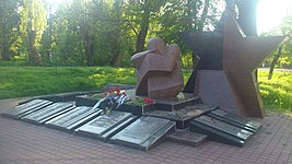
Monument to Crimeans who died in Afghanistan


Notes
- ↑ This geographical feature is located on the territory of the Crimean Peninsula , most of which is the subject of territorial disagreements between Russia , which controls the disputed territory, and Ukraine , within the borders of which the disputed territory is recognized by the international community. According to the federal structure of Russia , on the disputed territory of Crimea are the subjects of the Russian Federation - the Republic of Crimea and the city of federal significance Sevastopol . According to the administrative division of Ukraine , the regions of Ukraine are located in the disputed territory of Crimea - the Autonomous Republic of Crimea and the city with special status Sevastopol .
- ↑ 1 2 3 Shirokov, 1983 .
- ↑ 1 2 Sabyanin Nikolay. Embankment: a street with two names (inaccessible link - history ) . Fresh Newspaper (October 15, 2009). Date of treatment May 11, 2015.
- ↑ The embankment of Simferopol is a quiet beauty in the city center . Fresh newspaper. Date of treatment May 11, 2015.
Literature
- Shirokov V.A., Shirokov O.V. Embankment // Simferopol. The streets are telling. - Simferopol: Tavria, 1983.- 208 p. - 50,000 copies.
- Polyakov V.E. Streets of Simferopol. - Simferopol: Crimea. educational and pedagogical state Publishing House, 2005 .-- 320 p.
Links
- Sabyanin Nikolay. Embankment: a street with two names (inaccessible link - history ) . Fresh Newspaper (October 15, 2009). Date of treatment May 11, 2015.
- The embankment of Simferopol is a quiet beauty in the city center . Fresh newspaper. Date of treatment May 11, 2015.