Santa Rosa Island is the second largest island in the Channel Group, which is located off the coast of southern California , USA . Administratively refers to the county of Santa Barbara .
| Santa rose | |
|---|---|
| English Santa rosa island | |
| Specifications | |
| Square | 215.27 km² |
| Population | 2 pax (2000) |
| Population density | 0.01 people / km² |
| Location | |
| Water area | Pacific Ocean |
| A country |
|
| State | California |
| County | Santa Barbara |


It is located west of the island of Santa Cruz and east of the island of San Miguel, 42 km from the coast of California in the area of the city of Santa Barbara . The island is approximately 26 km long and 17 km wide. The relief of Santa Rosa is hilly. The highest point - Mount Vale, is 484 m above sea level. The shores of the island range from wide sandy beaches, gently sloping down to the ocean, to sheer cliffs. Santa Rosa is 215.27 km² in area, making it the 65th largest island in the United States . It is part of the Channel Islands National Park [1] .
The permanent population of the island according to the 2000 census is 2 people [2] . There is a year-round charter connection with Camarillo Airport .
In 2007, a new species of lichens was discovered on the island, named after the country's president - Kaloplac Obama ( lat. Caloplaca obamae ) [3] .
Gallery
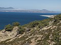
Pine Grove on Santa Rosa
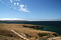
View from the hill

White sand beach


Notes
- ↑ National Park Service: Santa Rosa Island
- ↑ Block 3009, Block Group 3, Census Tract 29.10, Santa Barbara County (englisch)
- ↑ ScienceDaily. April 16, 2009. New Species Of Lichen Named After President Barack Obama . Accessed online April 16, 2009.