Kirundo ( fr. Kirundo ) - one of the 17 provinces of Burundi . Located in the far north-east of the country. Area - 1703 km², population 628,256 people [1] .
| provinces | |
| Kirundo | |
|---|---|
| fr Kirundo | |
| A country | |
| Includes | 7 communes |
| Adm Centre | Kirundo |
| History and geography | |
| Square | 1703 km² (8th place ) |
| Height | |
| Timezone | UTC + 2 |
| Population | |
| Population | 628 256 [1] people ( 2008 ) ( 4th place ) |
| Density | 368.91 people / km² (6th place) |
| Digital identifiers | |
| ISO 3166-2 code | BI-KI |
| FIPS Index | BY16 |
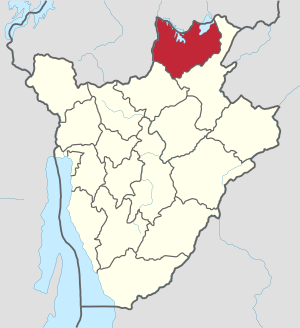 | |
The administrative center is the city of Kirundo .
Geography
In the east and southeast, it borders on the province of Muyinga , in the southwest - on the province of Ngozi , in the north and in the west lies the state border with Rwanda . In the northern part of the province there are lakes Rvera and Rahinda .
Administrative division
Kirundo is divided into 7 communes: [1]
- Bugabira
- Busoni
- Bwambarangwe
- Gitobe
- Kirundo
- Ntega
- Vumbi