Potaro-Siparuni is a region in Guyana . [1] The administrative center is the city of Madia .
| Region | |
| Potaro Siparuni | |
|---|---|
| English Potaro-siparuni | |
| A country | |
| Adm. Centre | Madia |
| History and Geography | |
| Square | 20,051 km² |
| Timezone | UTC -4 |
| Population | |
| Population | 10 190 people ( 2012 ) |
| Density | 0.51 people / km² |
| Digital identifiers | |
| ISO 3166-2 Code | Gy-08 |
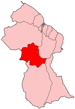 | |
In the north, Potaro-Siparuni borders on the Kuyuni-Mazaruni region , in the east with the regions of Upper Demerara-Berbis and East Berbis-Korentain , in the south with the region of Upper Takutu-Upper Essexibo , and in the west with Brazil .
Population
The Guyana government has conducted three official censuses since the 1980 administrative reforms: in 1980, 1991, and 2002. [2] In 2012, the population of the region reached 10,190. [3] Official census data for the Potaro-Siparuni region:
- 2012: 10,190 people
- 2002: 10,095 people
- 1991: 5,616
- 1980: 4,485
Notes
- ↑ Macmillan Publishers. Administrative Regions - 8, 9 and 10 // Macmillan Junior Atlas: Guyana. - Oxford: Macmillan Caribbean, 2009 .-- P. 37. - ISBN 9780333934173 .
- ↑ Beaie, Sonkarley Tiatun Chapter 3: National Redistribution and Internal Migration (PDF) (link not available) . 2002 Population and Housing Census - Guyana National Report . Bureau of Statistics (September 19, 2007). Date of treatment August 29, 2012. Archived September 2, 2012.
- ↑ Beaie, Sonkarley Tiatun National Population Trends: Size, Growth and Distribution (PDF Download). 2002 Population and Housing Census - Guyana National Report . Bureau of Statistics (September 19, 2007). Date of treatment August 29, 2012.