Demerara Mahaica is a region in Guyana . [1] The administrative center is the city of Paradise .
| Region | |
| Demerara Mahayka | |
|---|---|
| English Demerara-mahaica | |
| A country | |
| Adm. center | Paradise |
| History and Geography | |
| Area | 2 232 km² |
| Timezone | UTC -4 |
| Population | |
| Population | 313,429 people ( 2012 ) |
| Density | 140 people / km² |
| Digital identifiers | |
| ISO 3166-2 Code | Gy-04 |
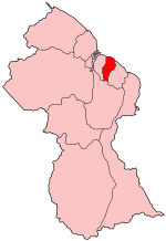 | |
In the north, the region borders the Atlantic Ocean , in the east with the Mahayka-Berbis region , in the south with the Upper-Demerara-Berbis region , and in the west with the Essexibo-Islands-West-Demerara region .
The Demerara Mahaika region includes the capital of Guyana - the city of Georgetown , as well as the cities of Buxton , Enmore , Victoria and Paradise .
Population
The Guyana government has conducted three official censuses since the 1980 administrative reforms: in 1980, 1991, and 2002. [2] Even though the region is the smallest, it has the largest population. In 2012, the population of the region reached 313,429 people. [3] Official census data for the Demerara Mahaika region:
- 2012: 313,429 people
- 2002: 310,320 people
- 1991: 296,924
- 1980: 317,475
Notes
- ↑ Macmillan Publishers. Administrative Region - 4 // Macmillan Junior Atlas: Guyana. - Oxford: Macmillan Caribbean, 2009 .-- P. 33. - ISBN 9780333934173 .
- ↑ Beaie, Sonkarley Tiatun Chapter 3: National Redistribution and Internal Migration (PDF) (link not available) . 2002 Population and Housing Census - Guyana National Report . Bureau of Statistics (September 19, 2007). Date of treatment August 29, 2012. Archived September 2, 2012.
- ↑ Beaie, Sonkarley Tiatun National Population Trends: Size, Growth and Distribution (PDF Download) (link not available) . 2002 Population and Housing Census - Guyana National Report . Bureau of Statistics (September 19, 2007). Date of treatment August 29, 2012. Archived on September 9, 2012.