Laska is a river in the Perm Territory , the right tributary of the Kama . The river flows into the Votkinsk reservoir , the mouth of the river is 638 km along the right bank of the Kama. The length of the river is 16 km. The length of the river is 78 [2] km. The catchment area is 481 [2] km².
| Lasva | |
|---|---|
| Characteristic | |
| Length | 78 km |
| Swimming pool | 481 km² |
| Watercourse | |
| Source | |
| • Height | above 210.6 m |
| • Coordinates | |
| Mouth | Votkinsk reservoir |
| • Location | 638 km on the right bank |
| • Height | 87.5 m |
| • Coordinates | |
| Location | |
| Water system | Votkinsk reservoir → Kama → Volga → Caspian Sea |
| A country |
|
| Region | Perm region |
| Areas | Ilyinsky district , Nytvensky district , Krasnokamsky district |
| HWR code | |
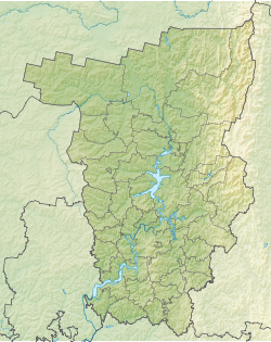
The source of the river on the Verkhnekamsk Upland in the tract Mitroshat 23 km south of the village of Ilyinsky . The source lies on the watershed with the Gareva basin.
It flows in the central part of the region on hilly terrain. The upper reaches are in the Ilyinsky district , then on a small stretch the river forms the border of the Nytvensky and Krasnokamsky districts , and the other course passes through the Krasnokamsky district. The flow rate in the summer is about 2 km / h, in the spring - much more. In high water , the water level rises by 2-3 m. The general direction of the current is southeast, in the lower reaches it turns southwest. The channel is very winding.
The largest settlements on the river are the village of Lasva and the village of Striapunyata ; in addition to them, the river flows the villages of Novosyol, Kalinintsy, Busyryat, Batury, Zhakovo, Katyshi, Abros, Ananichi.
Once or twice a year, water sports competitions are held (rescue work on catamarans, slalom catamarans and kayaks).
The river flows into Kama between the cities of Perm and Krasnokamsk . The width of the river at the mouth is about 35 meters.
Tributaries
(km from the mouth)
- Fence (lv)
- Sleeping (pr)
- Anashikha (lv)
- Khmelevka (pr)
- Silivanikha (lv)
- 43 km: Black (ave.)
- 45 km: Peremok (lv)
- Long (lv) [3] .
- Quick
- Whirlpool
- Long
- Malaya Ostanina
- Dolgusha
- Kamenka
Water registry data
According to the state water register of Russia, it belongs to the Kama Basin District , the water sector of the Kama River from the Kama Hydroelectric Complex to the Votkinsk Hydroelectric Complex , the river sub-basin - the Kama tributaries, up to the confluence of the White. The river basin of the river is Kama [4] .
Notes
- ↑ Surface Water Resources of the USSR: Hydrological Understanding. T. 11. The Middle Urals and the Urals. Vol. 1. Kama / ed. V.V. Nikolaenko. - L .: Gidrometeoizdat, 1966 .-- 324 p.
- ↑ 1 2 State Water Register . Laska River . textual.ru . Ministry of Natural Resources of Russia (March 29, 2009). Date of treatment December 20, 2018. Archived March 29, 2009.
- ↑ Map sheet O-40-XIV Krasnokamsk . Scale: 1: 200 000. Status of the area for 1979-1982. 1990 edition
- ↑ State Water Register of the Russian Federation: Laskva . Date of treatment February 4, 2015. Archived July 19, 2012.