Seti [1] ( Nepali. सेती अञ्चल ) is a zone (administrative unit) in the west of Nepal . It is part of the Far West region of the country . The administrative center is the city of Dipayal Silgadhi .
| Zone | |
| Networks | |
|---|---|
| Nepalese. सेती अञ्चल | |
| A country | Nepal |
| Included in | Far west region |
| Adm. Centre | Deepayal Silgadhi |
| History and Geography | |
| Square | 12 550 km² |
| Timezone | UTC + 5: 45 |
| Population | |
| Population | 1,575,003 people ( 2011 ) |
| Digital identifiers | |
| ISO 3166-2 Code | NP-SE |
 | |
 | |
Content
Population
According to the 2011 census, the population is 1,575,003 people; according to the 2001 census, it totaled 1,330,855 people [2] .
Geography
The area of the zone is 12,550 km². It borders with the Mahakali zone (in the west), the Karnali zone (in the northeast), the Bheri zone (in the southeast), as well as the Tibet Autonomous Region of China (in the north) and the Indian state of Uttar Pradesh (in the south).
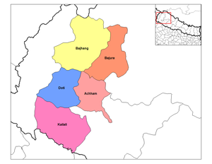
Administrative Division
The zone is divided into 5 areas:
- Achham
- Badzhang
- Bajura
- Doty
- Kailali
Notes
- ↑ Nepal, India (Upper Ganges Valley) // Atlas of the World / comp. and preparation. to the ed. PKO "Cartography" in 1999; open Ed .: T.G. Novikova , T.M. Vorobyova . - 3rd ed., Eras., Fr. in 2002 with diaposes. 1999 - M .: Roskartografiya, 2002. - S. 158. - ISBN 5-85120-055-3 .
- ↑ Nepal: Administrative Division. Zones and Districts. Citypopulation.de