
Six seventh territories of Nepal are occupied by ridges of the Himalayan mountain system.
The narrowest (20–40 km) strip at heights of 200–250 m above sea level stretches along the southern border. These are sandy-clay terai - the northern edge of the Indo-Gangetic lowland, the bulk of which belongs to India [1] . In some places they are swampy. In the summer, as a result of monsoon showers, small streams spread widely and cause flooding [2] .
From the north, Terai is closed by a gently hilly ridge called Sivalik - these are the foothills of the Himalayas (500-700 m above sea level), the lower step of the Himalayan mountain system. The local relief does not have sharp forms - low mountains and are strongly dissected by rivers. The northern slopes of Sivilika are cut with artificial terraces used by the local population for agriculture [2] .
A narrow depression with a hilly relief stretches to the north of the Sivilika ridges - the so-called Inner Terai (in Nepali - Bhitri-Madesh).
Further north is the middle step of the Himalayas - the mid-mountain ridge of the Mahabharat, or the Small Himalayas, with a height of up to 3000 m and a width of up to 16 km. It is composed of hard rocks, so many of the slopes of the Mahabharata are steep, the peaks are serrated. Not so long ago, the only mountain road from India to Kathmandu, the capital of Nepal, broke off here [1] .
Between the Mahabharat and the Main Himalayan Range, there is a lowering - the inner middle region (Midland, or Pahar Khanda). Its width is about 25 km, its height is from 600 to 2000 m. Here the rivers descend from the Himalayas. In the middle region is the most favorable for agriculture and the most populated part of the country - Kathmandu Valley with an area of about 600 km².
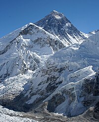
In the north, Pahar Khanda adjoins the Main Himalayan Range, or the Great Himalayas. The average height of the Great Himalayas is 6,000 m. In Nepalese, the Himalayas are the Himalayas, which means “abode of snow”. In the country, more than 1300 mountain peaks are covered with snow. In Nepal, there are eight of the world's 14 peaks exceeding 8,000 m. Among them, Sagarmatha (8848 m) is the highest peak on the planet, located on the border with China . The main Himalayan ridge has sharp jagged outlines, and its steep slopes abound in deep gorges [2] .
In the eastern part of Nepal, the crest of the Main Himalayan Range serves as the state border with the PRC , in the western half, the border with the PRC extends several tens of kilometers north of the Main Himalayan Ridge.
Notes
- ↑ 1 2 Nepal . Date of treatment June 6, 2014.
- ↑ 1 2 3 Relief of Nepal . Date of treatment June 6, 2014.