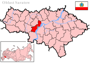
Saratov district is an administrative-territorial unit ( district ) and a municipality ( municipal district ) in the Saratov region of Russia .
| Municipal District | |||||
| Saratov district | |||||
|---|---|---|---|---|---|
| |||||
| A country | |||||
| Included in | Saratov region | ||||
| Includes | 12 municipalities | ||||
| Adm. Centre | Saratov city (not included in the district) | ||||
| Head of the municipal district | Baboshkin Ivan Anatolyevich | ||||
| History and Geography | |||||
| Date of formation | July 23, 1928 | ||||
| Square | 1935.53 [1] km² | ||||
| Timezone | MSK + 1 ( UTC + 4 ) | ||||
| Population | |||||
| Population | ↘ 50 319 [2] people ( 2018 ) (2.06%) | ||||
| Density | 26 people / km² | ||||
| Okato | 63,243,000,000 | ||||
| Official site | |||||
 | |||||


The administrative center is the city of Saratov (not part of the district).
Geography
Saratov district is a suburban district of the regional center, located on the right bank of the Volga , covering the city of Saratov in a semi-ring. The area is located on the Volga Upland , the plateau and slopes of which are covered with forest.
It borders with the Voskresensky , Bazarno-Karabulaksky , Novoburassky districts from the north, with Tatishchevsky , Lysogorsky districts from the west, with the Krasnoarmeysky district from the south and with Engels and Marksovsky districts from the east.
The length of paved public roads is 323.7 km.
- Rivers of the Saratov region
Berezina, Volga, Goryuchka, Gryaznukha, Guselka 1st, 2nd, Yelshanka, Karamysh, Kurdyum, Latryk, Nazarovka, Robbery, Sosnovka, Chernikha.
History
The district was formed on July 23, 1928 as part of the Saratov district of the Lower Volga region . It included part of the territory of the former Saratov district of the Saratov province .
Since 1934, the district is part of the Saratov region , since 1936 - in the Saratov region .
From 1937 to 1957, the district was called Voroshilovsky in honor of K. E. Voroshilov [3] .
January 1, 2005, the Saratov Municipal District was formed as a municipality [4] .
Population
| Population | ||||||
|---|---|---|---|---|---|---|
| 1989 [5] | 2002 [6] | 2009 [7] | 2010 [5] | 2011 [8] | 2012 [9] | 2013 [10] |
| 45 743 | ↗ 46 233 | ↗ 47 175 | ↗ 48 105 | ↘ 48,086 | ↗ 48 558 | ↗ 49 117 |
| 2014 [11] | 2015 [12] | 2016 [13] | 2017 [14] | 2018 [2] | ||
| ↗ 49 683 | ↗ 49 955 | ↗ 50 381 | ↗ 50 632 | ↘ 50 319 | ||
- Urbanization
In urban conditions (the working village of Krasny Oktyabr and Sokolovy ) 18.81% of the population of the region live.
Municipal Territory
The Saratov municipal district includes 12 municipalities , including 2 urban settlements and 10 rural settlements [15] :
| No. | Municipality | Administrative center | amount populated points | Population | Square, Km 2 |
|---|---|---|---|---|---|
| City settlements: | |||||
| one | Krasnooktyabrsky Municipality | workers village Red October | one | ↘ 3187 [2] | 17.70 [1] |
| 2 | Sokolovsk municipality | working village Sokolovy | one | ↗ 6279 [2] | 57.80 [1] |
| Rural settlements: | |||||
| 3 | Alexander municipality | Teplichny settlement | 9 | ↗ 6843 [2] | 82.60 [1] |
| four | Bagaevsky municipality | Bagaevka village | five | ↘ 3087 [2] | 77.63 [1] |
| five | Volnovsky municipality | Shevyrevka village | eight | ↘ 4024 [2] | 176.00 [1] |
| 6 | Dubkovsky municipality | Dubki village | 7 | ↗ 6538 [2] | 244.91 [1] |
| 7 | municipality Red Textile | Red Textile Village | 2 | ↘ 3289 [2] | 5.23 [1] |
| eight | Mikhailovsky municipality | village Mikhailovka | 18 | ↘ 4305 [2] | 389.20 [1] |
| 9 | Raskovo municipality | Raskovo village | 6 | ↘ 3503 [2] | 114.50 [1] |
| ten | Rybushan Municipality | Rybushka village | eight | ↘ 2715 [2] | 379.24 [1] |
| eleven | Sinen Municipality | Sinenkie village | 9 | ↘ 2892 [2] | 299.58 [1] |
| 12 | Ust-Kurdyum municipality | Ust-Kurdyum village | five | ↗ 3657 [2] | 106.14 [1] |
The Saratov district included 18 administrative districts [16] , shown on the map:
- Aleksandrovsky district (the center of the district - p. Teplichny)
- Bagaevsky district (the center of the district - p. Bagaevka )
- Volnovsky District (the center of the district is the village of Shevyryovka)
- Dubkovsky District (the center of the district - Dubki)
- Ivanovo district (the center of the district - p. Teplichny)
- Ivanovsky village
- Kleshchevsky district (the center of the district - v. Kleshchevka)
- Krasnooktyabrsky district (the center of the district is the village of Red October)
- Krasnotekstilshchikovsky district (the center of the district is the village of Krasny Tekstilshchik)
- Mikhailovsky district (center of the district - v. Mikhailovka )
- Popovsky District (the center of the district - v. Popovka)
- Raskovo district (the center of the district - Raskovo village)
- Rybushansky district (the center of the district - v. Rybushka)
- Saburovsky district (the center of the district - s. Saburovka)
- Sergievsky district (the center of the district - p. Sergievsky)
- Sinenki district (the center of the district is the village of Sinenkie )
- Sokolovsky District (the center of the district is the village of Sokolovy)
- Sosnovsky district (the center of the district - s. Sosnovka )
- Ust -Kurdyum district (the center of the district is the village of Ust-Kurdyum )
In 2004, after the reform of local self-government, the Law of the Saratov Region dated December 23, 2004 No. 78-ЗСО “On Municipal Areas” formed 12 municipal entities in the Saratov Region [17] :
In February 2012, the Law of the Saratov Region “On Amending the Law of the Saratov Region“ On Municipalities That Are Part of the Saratov Municipal District ”” changed the status of the municipality of Red Tekstilshchik from urban settlement to rural settlement [18] .
Settlements
There are 79 settlements in the Saratov region.
| List of settlements of the district | ||||
|---|---|---|---|---|
| No. | Locality | Type of | Population | Municipal education |
| one | Avdeevka | village | 0 [5] | Alexandrovskoe |
| 2 | Alexandrovka | village | 1782 [5] | Alexandrovskoe |
| 3 | Atamanovka | farm | 25 [5] | Raskovsky |
| four | Babanovka | village | 0 [5] | Sinenskoe |
| five | Bagaevka | village | 1539 [5] | Bagaevskoe |
| 6 | Bartolomeevsky | farm | 267 [5] | Raskovsky |
| 7 | Belenky | village | 36 [5] | Red textile worker |
| eight | Berezina River | village | 1065 [5] | Alexandrovskoe |
| 9 | Sidewall | village | 39 [5] | Volnovskoe |
| ten | Burki | railroad station | 16 [5] | Mikhailovsky |
| eleven | Burkin Buerak | village | 46 [5] | Mikhailovsky |
| 12 | Bullock | village | 42 [5] | Rybushanskoe |
| 13 | Upper Kurdyum | village | 228 [5] | Mikhailovsky |
| 14 | Vlasovsky | village | 6 [5] | Mikhailovsky |
| 15 | Vlasovsky | railroad station | 8 [5] | Mikhailovsky |
| sixteen | Vodnik | village | 394 [5] | Alexandrovskoe |
| 17 | Volnovka | village | 343 [5] | Volnovskoe |
| 18 | Knitting | village | 34 [5] | Volnovskoe |
| nineteen | Knitting | village | 2 [5] | Mikhailovsky |
| 20 | Goryuchka | railway junction | 17 [5] | Sinenskoe |
| 21 | Gotovitsky | village | 5 [5] | Dubkovskoe |
| 22 | Dolgiy Buerak | village | 163 [5] | Ust-Kurdyum |
| 23 | Oaks | village | ↗ 4416 [5] | Dubkovskoe |
| 24 | Eremeevka | village | 29 [5] | Alexandrovskoe |
| 25 | Eseevka | village | 16 [5] | Sinenskoe |
| 26 | Zlobovka | village | 2 [5] | Mikhailovsky |
| 27 | Zorinsky | railway junction | Raskovsky | |
| 28 | Zorinsky | village | 579 [5] | Raskovsky |
| 29th | Ivanovsky | village | 778 [5] | Mikhailovsky |
| thirty | Kalashnikov | village | 110 [5] | Alexandrovskoe |
| 31 | Tick-borne | village | 1038 [5] | Dubkovskoe |
| 32 | Kozlakovka | village | 16 [5] | Mikhailovsky |
| 33 | Kozlovka | village | 58 [5] | Volnovskoe |
| 34 | Kokurino | village | 145 [5] | Alexandrovskoe |
| 35 | Kolotov Buerak | village | 101 [5] | Mikhailovsky |
| 36 | Konstantinovka | village | 346 [5] | Mikhailovsky |
| 37 | Red October | village | 14 [5] | Rybushanskoe |
| 38 | Red October | working village | ↘ 3187 [2] | Krasnooktyabrskoe |
| 39 | Red textile worker | village | ↗ 3412 [8] | Red textile worker |
| 40 | Krutets | village | 9 [5] | Sinenskoe |
| 41 | Small fish | village | 0 [5] | Rybushanskoe |
| 42 | Malaya Skatovka | farm | 553 [5] | Raskovsky |
| 43 | Mahino | village | 16 [5] | Rybushanskoe |
| 44 | Lighthouse | farm | 46 [5] | Mikhailovsky |
| 45 | Mergichevka | village | 67 [5] | Ust-Kurdyum |
| 46 | Mikhaylovka | village | 1015 [5] | Mikhailovsky |
| 47 | New Lipovka | village | 191 [5] | Dubkovskoe |
| 48 | New alexandrovka | village | 17 [5] | Mikhailovsky |
| 49 | Novoguselsky | village | 241 [5] | Ust-Kurdyum |
| 50 | Sandy Umet | village | 51 [5] | Mikhailovsky |
| 51 | Popovka | village | 989 [5] | Rybushanskoe |
| 52 | Piers | village | 437 [5] | Ust-Kurdyum |
| 53 | Pudovkino | village | 143 [5] | Sinenskoe |
| 54 | Raskovo | village | 1978 [5] | Raskovsky |
| 55 | Posting | village | 16 [5] | Volnovskoe |
| 56 | Layout 1st | village | 106 [5] | Dubkovskoe |
| 57 | Reynik | village | 817 [5] | Alexandrovskoe |
| 58 | Fish | village | 1283 [5] | Rybushanskoe |
| 59 | Saburovka | village | 427 [5] | Volnovskoe |
| 60 | Sdrobovka | village | 151 [5] | Rybushanskoe |
| 61 | Lead Free | village | 246 [5] | Dubkovskoe |
| 62 | Agricultural machinery | village | 341 [5] | Bagaevskoe |
| 63 | Sergievsky | village | 1387 [5] | Sinenskoe |
| 64 | Little blue | village | 1187 [5] | Sinenskoe |
| 65 | Falcon | working village | ↗ 6279 [2] | Sokolovskoe |
| 66 | Sosnovka | village | 735 [5] | Mikhailovsky |
| 67 | Tarkhan | railroad station | 1971 [5] | Volnovskoe |
| 68 | Greenhouse | village | 2013 [5] | Alexandrovskoe |
| 69 | Crackle | village | 41 [5] | Bagaevskoe |
| 70 | Ust-Kurdyum | village | 1898 [5] | Ust-Kurdyum |
| 71 | Farm | farm | 21 [5] | Dubkovskoe |
| 72 | Formosovo | village | 11 [5] | Sinenskoe |
| 73 | Khmelevka | village | 349 [5] | Bagaevskoe |
| 74 | Khmelevsky | village | 703 [5] | Bagaevskoe |
| 75 | Central estate of the farm "15 years of October" | village | 364 [5] | Rybushanskoe |
| 76 | Chevyrevka | village | 1124 [5] | Volnovskoe |
| 77 | Wide Buerak | village | 151 [5] | Sinenskoe |
| 78 | Yurlovka | village | 464 [5] | Mikhailovsky |
| 79 | Yuryevka | village | 124 [5] | Mikhailovsky |
Economics
In the area, oil , gas , and construction materials are being developed.
The district is agricultural , poultry (there are several poultry farms), vegetables, fruits, sunflowers , cereals are grown, the region’s once-developed livestock breeding is in ruined condition, infrastructure, farms, storage facilities, parks, MTS and other industrial livestock breeding facilities are completely destroyed. Little blue, s. Sergievskoe, with. Popovka, s. Bagaevka, s. Ivanovsky and others. In a state of devastation, there is a repair enterprise of agricultural machinery Bagaevskaya SKHT.
There are a number of industrial enterprises, a reinforced concrete products factory and an elevator in Tarkhany, on the territory of which cardboard is now being made, a brick factory in Aleksandrovka, and a new GRAS brick factory in this village has also been launched. Also, until 2006, a tobacco factory operated in Tarkhany. The textile factory in Red Textile Worker is closed and is currently not operational. Workers fired.
Transport
On the territory of the Saratov region there are 2 road and 1 railway bridge across the Volga :
- The Saratov bridge connects the cities of Saratov and Engels . Its length is 2825.8 meters. At the time of construction ( 1965 ) - the longest bridge in Europe.
- The Pristan bridge is located in the vicinity of the village of Pristannoe in the Saratov region and connects it with the village of Shumeyka, Engels district . Opened in 2009 . The length of the main span of the bridge is 1228 meters, the total length with access structures is 12 760 meters.
- The Saratov railway bridge connects the village of Uvek in the territory of Saratov with the urban-type settlement Volga . Opened in 1935 . The total length of 1850 meters.
3 federal highways P228 ( Syzran - Saratov - Volgograd ), A144 ( Saratov - Voronezh - Kursk ) pass through the district, after A144 it is renamed to R 298 and P158 ( Saratov - Penza - Nizhny Novgorod ) after 12/31/2017 (291.9 km in the district) and one regional road P234 (Peschano-Umetskoye highway) (21.9 km in the region).
The railway lines “Saratov- Moscow ”, “Saratov- Kazan ” and “Saratov- Volgograd ” operate [19] .
Passenger transport
Buses:
- 217 Volga Stadium (Saratov) - Aleksandrovka
- 218 Volga Stadium (Saratov) - SZSM
- 222 St. Radishcheva (Saratov) - Cottages of SSU
- 223 Collective farm pl. (Saratov) - Oaks
- 223t Square Lenin (Saratov) - Oaks
- 224 Volga Stadium (Saratov) - Treshchikha
- 225 Collective farm pl. (Saratov) - Red October
- 226 Bus Station / Volga Stadium (Saratov) - Red Textile Worker
- 229 Sq. Lenin (Saratov) - Raskovo
- 230 Sokursky tract (Saratov) - Latukhino
- 232 collective farm (Saratov) - Mikhaylovka
- 236 St. Radishcheva (Saratov) - Volga Dali - Pristan
- 238 Collective farm pl. (Saratov) - Lead
- 238k collective farm square (Saratov) - Kishchevka (canceled)
- 239 Sq. Lenin (Saratov) - pos. Falcon
- 240 st. Radishcheva (Saratov) - Tubraz "Falcon"
- 242k collective farm square (Saratov) - The Watchtower
- 243 St. Radishcheva (Saratov) - Ust-Kurdyum
- 245 Collective farm pl. (Saratov) - Chevyrevka
- 283 Bus station (Saratov) - Sinenkie
- 285 Bus station (Saratov) - Rybushka - 15 years of October
- 291 Square Lenin (Saratov) - Sbrodovka
- 299 Volga Stadium (Saratov) - Wide Buerak
- 329 Collective farm pl. (Saratov) - Zorinsky
- 330 Collective farm pl. (Saratov) - Sosnovka - Safarovka - Yurlovka
- 348 sq. Lenin (Saratov) - Scatovka
- 358 Collective farm pl. (Saratov) - Saburovka
- 383 Volga Stadium (Saratov) - Sosnovka
- 389 Collective farm pl. (Saratov) - Mikhaylovka
- 391 St. Radishcheva (Saratov) - Dolgiy Buerak
- 419 Volga Stadium (Saratov) - Safarovka
Media
The newspaper "Big Volga", which is the official body of the Saratov municipal district, is published in the district. The newspaper has a website on the Internet - "Big Volga" .
Attractions
The district’s attraction is the Zlobovsky Forest (near the village of Zlobovka) - near the highway to Voronezh . More than 50 species of exotic trees and shrubs from North America , Europe , the Caucasus , Crimea and other regions of the world grow in the forest (now a botanical reserve).
Near the village of Shevyryovka on the Yelshanka River is one of the largest ponds in the region. Near the village of Ust-Kurdyum is the venue of the traditional summer Tatar holiday "Sabantuy" .
See also
- Administrative division of the Saratov region
- Settlements of the Saratov Region
- Coats of arms of the regions of the Saratov region
Notes
- ↑ 1 2 3 4 5 6 7 8 9 10 11 12 13 Saratov region. The total land area of the municipality
- ↑ 1 2 3 4 5 6 7 8 9 10 11 12 13 14 15 16 The population of the Russian Federation by municipalities as of January 1, 2018 . Date of treatment July 25, 2018. Archived July 26, 2018.
- ↑ Saratov region on the site “World Historical Project” Archived on December 3, 2010.
- ↑ Law of the Saratov Region dated December 23, 2004 No. 78-ЗСО “On Municipal Areas”
- ↑ 1 2 3 4 5 6 7 8 9 10 11 12 13 14 15 16 17 18 19 20 21 22 23 24 25 26 27 28 29 30 31 32 33 34 35 36 37 38 39 40 41 42 43 44 45 46 47 48 49 50 51 52 53 54 55 56 57 58 59 60 61 62 63 64 65 66 67 68 69 70 71 72 73 74 75 76 77 2010 All-Russian Population Census. The number and distribution of the population of the Saratov region . Date of treatment July 6, 2014. Archived July 6, 2014.
- ↑ 2002 All-Russian Population Census. Tom. 1, table 4. The population of Russia, federal districts, constituent entities of the Russian Federation, regions, urban settlements, rural settlements - district centers and rural settlements with a population of 3 thousand or more . Archived February 3, 2012.
- ↑ The number of permanent population of the Russian Federation by cities, urban-type settlements and districts as of January 1, 2009 . Date of treatment January 2, 2014. Archived January 2, 2014.
- ↑ 1 2 Saratov region. Estimated resident population as of January 1, 2009-2015
- ↑ Population of the Russian Federation by municipalities. Table 35. Estimated resident population as of January 1, 2012 . Date of treatment May 31, 2014. Archived May 31, 2014.
- ↑ The population of the Russian Federation by municipalities as of January 1, 2013. - M.: Federal State Statistics Service of Rosstat, 2013. - 528 p. (Table 33. The population of urban districts, municipalities, urban and rural settlements, urban settlements, rural settlements) . Date of treatment November 16, 2013. Archived November 16, 2013.
- ↑ Table 33. The population of the Russian Federation by municipalities as of January 1, 2014 . Date of treatment August 2, 2014. Archived on August 2, 2014.
- ↑ The population of the Russian Federation by municipalities as of January 1, 2015 . Date of treatment August 6, 2015. Archived on August 6, 2015.
- ↑ Population of the Russian Federation by municipalities as of January 1, 2016
- ↑ The population of the Russian Federation by municipalities as of January 1, 2017 (July 31, 2017). Date of treatment July 31, 2017. Archived July 31, 2017.
- ↑ Law of the Saratov Region of December 29, 2004 N 113-ЗСО “On Municipalities Included in the Saratov Region”
- ↑ Administrative territorial division of the Saratov region
- ↑ Charter of the Saratov municipal district
- ↑ Law of the Saratov Region dated February 20, 2012 No. 20-ЗСО “On Amendments to the Law of the Saratov Region“ On Municipalities Included in the Saratov Municipal District ””
- ↑ Information about the Saratov region
Literature
- Atlas of highways of the Saratov region. Saratov, 2000.