Utesnoe is a village in the Ussuriisk urban district of Primorsky Krai . Included in the Krasnoyarovsk territory [2] [3] .
| Village | |
| Rock | |
|---|---|
| Suifun | |
 | |
| A country | |
| Subject of the federation | Primorsky Krai |
| Municipal district | Ussuri |
| History and geography | |
| Based | 1938 |
| Timezone | UTC + 10 |
| Population | |
| Population | ↘ 388 [1] people ( 2010 ) |
| Digital identifiers | |
| Telephone code | +7 4234 |
| Postal codes | 692548 |
| OKATO code | 05423000036 |
| OKTMO code | |
Until 1972, the village was called Suifun , and the river on which the village stands was Suifun . After the armed conflict over Daman Island in the Primorsky Territory, all Chinese geographical names were renamed , the river was called Razdolnaya [4] .

Content
Geography
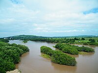
Utesnoe village stands on the high right bank of the Razdolnaya river.
Utesnoe village is a satellite of Ussuriysk .
The distance to the city is small, about 3 km to the north.
The road to the village Utesnoe is a continuation of the street. Lermontov, walks past the Soldier Lake .
To the south of the village Utesnoe the road goes to the village of Krasny Yar and then to the highway " Razdolnoye - Khasan ".
To the west of the village of Utesnoe there is a road to the villages of Linevichi and Kuguki .
Population
| Population | ||
|---|---|---|
| 1868 [5] | 2002 [6] | 2010 [1] |
| 24 | ↗ 389 | ↘ 388 |
Economy
- Agricultural enterprises of the Ussuriysky urban district.
- Cottage plots of the Ussuriites.
Attractions
- Krasnoyarovsk fort - archaeological site.
- On the left bank of the Razdolnaya opposite the village of Utesnoe, a monument was erected to the Korean independence fighter Lee Sang Solu (1878-1917), whose ashes were scattered after cremation in this place.
Facts
- In the 1970s there was no bridge over the Suifun River, people and cars across the river were transported by cable ferry (about 200 m below the existing bridge).
Notes
- ↑ 1 2 Population of urban districts, municipalities, urban and rural settlements, urban settlements, rural settlements. All-Russian population census of 2010 (as of October 14, 2010). Primorsky Territory . Date of treatment August 31, 2013. Archived June 11, 2013.
- ↑ Legislative assembly of the Primorsky Territory. Collection "Municipalities of the Primorsky Territory"
- ↑ Official site of UGO
- ↑ Decision of the Council of Ministers of the RSFSR No. 753 of December 29, 1972
- ↑ Przhevalsky N.M. Applications The statistical table of the peasant population in the South Russian region and on the coast of the Sea of Japan // Travel in the Ussuri region, 1868-1869 .. - St. Petersburg. , 1870. - 374 p.
- ↑ Data from the 2002 All-Russian Population Census: Table No. 02c. Population size and the predominant nationality for each rural locality. M .: Federal State Statistics Service, 2004