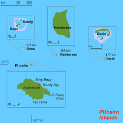

Pitcairn Islands consist of four islands:
- Pitcairn Island (main island) ( )
- Henderson ( )
- Duxie ( )
- Oeno ( )
Pitcairn Island is a volcanic island , Henderson is a coral island , Ducy and Oeno are atolls .
The only inhabited island - Pitcairn, has an area of 5 km 2 (1.9 sq. Miles) and a population density of 10 people per square kilometer. The island can only be accessed through the Bounty Bay .
Content
Accommodation
Oceania , an island in the South Pacific , about halfway between Peru and New Zealand , is one of the most remote human locations on Earth. The populated island, Pitcairn, is located about 2,170 kilometers southeast of Tahiti , 5,310 kilometers from Auckland , and about 6,600 kilometers from Panama . The largest settlement closest to Adamstown is the village of Rikitea, the administrative center of the Gambier Islands (French Polynesia), located 540 km to the west.
Area
Total: 47 km 2 (18 sq. Miles) Land: 47 km 2 (18 sq. Miles) Water: 0 km 2 (0 sq. Miles)
Land Borders
0 kilometers
Coastline
51 kilometers
Climate
Tropical, hot, humid; temperatures range from 16 ° C on winter nights to 30 ° C on summer days.
Landscape
Islands of volcanic origin; rocky shores with cliffs.
Elevations
Lowest point: Pacific Ocean, 0 meters Highest Point: Pawala Valley Ridge, 347 meters