Svirzh ( Ukrainian Svirzh ) - a river in the Peremyshlyansky district of the Lviv region and in the Rogatinsky and Galichsky districts of the Ivano-Frankivsk region , Ukraine . Left tributary of the Dniester ( Black Sea basin ).
| Svirzh | |
|---|---|
| ukr Svіrzh | |
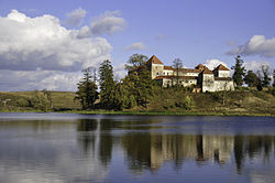 View of the Svirzhsky Castle from the side of the pond on Svirzh View of the Svirzhsky Castle from the side of the pond on Svirzh | |
| Characteristic | |
| Length | 70 km |
| Pool | 447 km² |
| Watercourse | |
| Source | |
| • Location | west of the village Svirzh |
| • Coordinates | |
| Mouth | Dniester |
| • Coordinates | |
| Location | |
| Water system | Dniester → Black Sea |
| A country |
|
| Regions | Lviv region , Ivano-Frankivsk region |
| Areas | Peremyshlyansky District , Rogatinsky District , Galichsky District |

The length of the river is 70 km, the basin area is 447 km². The slope of the river is 1.6 m / km. The upper valley is V-shaped, below it is mostly trapezoidal. The floodplain is two-sided, with a width of 0.1 to 1 km. The course is tortuous, branched in places, partially straightened. There are ponds (for example, in the villages of Svirzh and Zagorje ).
It originates to the east of the Kamula mountain (the highest peak of the Podolsky Upland , 471.9 m), within the limits of the Hologory Ledge. It flows from north to south and southeast, flows into the Dniester west of the village Tenetniki .
The main tributary is Lyubeshka (right).
The border between Lviv and Galician lands of the Kingdom of Poland ran along the Svirzh River from the village of Pribyn right up to the confluence of the river into the Dniester.
On one of the ponds, built on the river, stands the famous Svirzhsky Castle .
Literature
- Geographic encyclopedia of Ukraine : in 3 t / Redcol .: AM Marinich and others. - K .: Ukrainian radian encyclopedia, 1989-1993. - ISBN 5-88500-015-8 . (in Ukrainian)
- Svirzh // Directory of Ukraine / Comp.: G. І. Shvets , N. І. Drozd , S.P. Levchenko ; Ed .: V.I. Moklyak . - Kiev : View of the Academy of Sciences of the URSR , 1957. - 192 p. - 3000 copies (in Ukrainian)