Stanislav Pakholovitsky ( Belorussian. Stanislaў Pakhalavetsky ; Polish. Stanisław Pachołowiecki ) - royal secretary and cartographer of Stefan Batory .
| Stanislav Pakholovitsky | |
|---|---|
| Belor. Stanislaў Pahalavetsky | |
| Date of Birth | |
| Nationality | Polish-Lithuanian Commonwealth |
| Occupation | |
Pakholovitsky’s active cartographic activity occurred during the Polotsk campaign of Stefan Batory in 1579, as a result he created a number of maps and sketches of the fortifications of Polotsk land. He owns: a map of the Polotsk Voivodeship, plans for Russian fortresses (along with Stanislav Sulimovsky) taken by the king, including two detailed plans for the siege of Polotsk .
Maps and plans of Pakholovitsky - one of the first works of military cartography of the Grand Duchy of Lithuania and the Commonwealth , are of great interest to the history of architecture and fortification .
Drawings of Russian fortresses have survived to our days thanks to the engravings made by them by J. B. Cavalieri in Rome in 1580.
Gallery
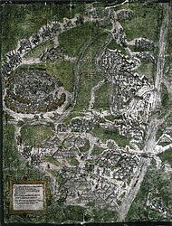
The siege of Polotsk by the troops of Stephen Batory in 1579, watercolor.
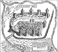
Sokol Castle in 1579
engraving by J. B. Cavalieri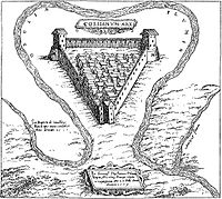
Kozjansky castle in 1579,
engraving by J. B. Cavalieri


Literature
- Kazloў L.R. Belarus in prazakh of the Polish cartographerў XVI — XX centuries .. - Mn. : Arty-Faks, 2004 .-- 115 p. - ISBN 985-6119-42-1 .