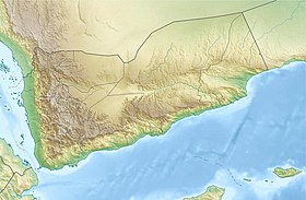
Kharaz ( Arabic: جبل حراز ) is a ridge of the Yemen mountains between Sana'a and Hodeida . The Kharaz Mountains are located 90 km west-south-west of Sana'a. In the XI century, it was the stronghold of the Suliahid dynasty , many of whose buildings are still intact.
| Haraz | |
|---|---|
| Arab. جبل حراز | |
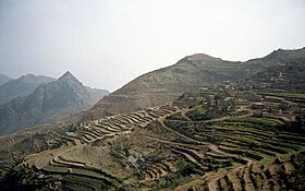 View of the Kharaz mountains from the village of Manakh. | |
| Location | |
| A country |
|
| Region | Sana'a |
 | UNESCO World Heritage Site , Object No. 1722 Russian • English • fr. |
Content
World Heritage Status
This area, with coordinates in the center of latitude 15 ° 10'N and longitude 43 ° 45'E, is listed in the Preliminary lists of UNESCO World Heritage Sites on July 8, 2002 in the mixed cultural and natural category (cultural landscape), as a place with an “outstanding universal value. " [one]
History
This highland region has always been strategically important because of its location between Sana'a and Tijama . This is the stopping point for caravans during the time of the Himyar kingdom . Then Kharaz became a stronghold of the Sulaykhid state, which was created in 1037. Then and subsequently, the population of this region were Ismaili Muslims .
The beautiful village of Al-Hajjar , west of Manakh , was founded as a stronghold in the 12th century by the Sulayhids .
Area Description
Khazar is also famous for the beauty of its landscapes, since for its fortified villages cling to almost inaccessible rocky peaks. With their impressive architecture, settlements meet two needs: to protect residents and there is a lot of room for crops. Each settlement is built like a castle. The houses themselves form walls equipped with one or two well-protected doors. Built of sandstone and basalt, the buildings are perfectly integrated into the landscape , and it’s hard to tell where the rock and the village begin or end. The mountains are divided into terraces of several hectares or more, separated by walls, sometimes several meters high. Alfalfa for livestock, millet , lentils , large areas for coffee and catatas grow on these wonderful terraced fields.
Benu Mora is at the bottom of the road from other villages located on the ridge overlooking the city of Manakha . The sufficiently large city of Manakh is considered the heart of this thriving mountainous area - its market attracts residents from all over the area. The beautiful walled village of Al-Hajjar , west of Manakh , as a citadel was founded in the 12th century. Other villages are available from here, such as Beit El Camus and Beit Shimran . The village of Hutaib is built on a red sandstone platform overlooking the magnificent views on the hill terraces that contain the village. Here is also the mausoleum of the third Yemeni "Dai" Hatim al-Hamdi . Mustaliths of the Bohra branch from India, Sri Lanka, Singapore and Madagascar gather here. Local Ismailis for believers cover the roads and pave the streets of the city without damaging the landscape.
See also
- Yemen mountains
- Manaha
- Al Hajer