Masovian Voivodeship ( Latin Palatinatus Masoviensis , Polish. Województwo mazowieckie ) is an administrative-territorial unit of the Kingdom of Poland and the Commonwealth . It existed in the years 1529 - 1795 .
| Voivodship | |||
| Masovian Voivodeship | |||
|---|---|---|---|
| polish Województwo mazowieckie lat Palatinatus masoviensis | |||
| |||
| A country | Polish-Lithuanian Commonwealth | ||
| Included in | Crown of the Kingdom of Poland | ||
| Includes | Warsaw, Cherskaya, Viznenskaya, Vyshogrudskaya, Zakrochimskaya, Lomzhinskaya, Nurskaya, Ruzhanskaya, Tsekhanuvskaya and Libyan lands | ||
| Adm. Centre | Warsaw | ||
| Governors | ( list ) | ||
| The number of senators | eight | ||
| History and Geography | |||
| Date of formation | 1529 - 1795 | ||
| Date of Abolition | |||
| Square | 22 571.77 km² | ||
| Largest cities | Warsaw , Chersk , Vyshogrud , Zakrochim , Lomza , Nur, Rujan , Ciechanow , Liv | ||
| Population | |||
| Population | 402 368 people ( 1790 ) | ||
| Nationalities | Poles | ||
| Denominations | Catholics | ||
| official languages | polish latin | ||
 | |||
![Coat of arms [d]](http://upload.wikimedia.org/wikipedia/commons/thumb/7/7d/POL_wojew%C3%B3dztwo_mazowieckie_IRP_COA.svg/90px-POL_wojew%C3%B3dztwo_mazowieckie_IRP_COA.svg.png)
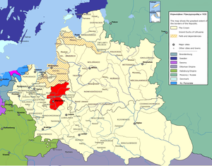
Masovian Voivodeship was created on the basis of the lands of the Masovian Principality . It was part of the Greater Poland province and belonged to the Mazovia region. It was located in the western part of the Commonwealth , in the east of Mazovia. The center of the voivodship is the city of Warsaw , the capital of the Commonwealth . Led by the voivode of the Mazovian . The Sejm of the Voivodeship also gathered in Warsaw .
The Masovian Voivodeship was represented by 8 senators in the Senate of the Polish-Lithuanian Commonwealth (the voivode of Mazovia, Chertian , Wiesnien , Vysogrudok , Zakrochimsky , Warsaw, Ciechanow and Livonian). It consisted of 10 lands (Warsaw, Chersky, Vizenskaya, Vyshogrudskaya , Zakrochim , Lomzhinsky, Nursky, Ruzhansky , Tsekhanuvskaya and Livsky lands) and 25 counties. The area of the province is 22 571.77 km², according to the census of 1790 the population was 402 368 people.
In 1795, after the Third Partition of the Polish-Lithuanian Commonwealth, the Masovian Voivodeship was liquidated and divided between Prussia and Austria . Most of the province's territory became part of the Prussian province of New East Prussia , and a smaller part - in the administrative region of Western Galicia of the Austrian Empire.
Administrative device
- Blonsky County - Blonie (Warsaw Land)
- Varksky district - Varka (Chersky land)
- Warsaw County - Warsaw (Warsaw Land)
- Vasoshsky County - Vasosh (Viznenskaya Zemlya)
- Vyshogrud County - Vyshogrud (Vyshogrud land)
- Wiesen County - Vizna (Wiesen Land)
- Gruetsky district - Gruec ( Cher land )
- Zakrochimsky district - Zakrochim (Zakrochimsky land)
- Zambrow County - Zambrow (Lomza region)
- Kamenchikovsky District - Kamyanchik (Nurskaya land)
- Kolnensky district - Kolno (Lomzhinsky land)
- Libyan County - Liv (Lomza region)
- Lomzhinsky County - Lomza (Lomza region)
- Makuv County - Makuv (Rozhany land)
- Novomyastsky County - Nowe Miasto-Lubavsk
- Nur district - Nur ( Nur land )
- Ostrow County - Ostrow (Nur region)
- Ostroleka County - Ostroleka ( Lomzhinsky land )
- Pshasnysh County - Pshasnysh (Ciechanow Land)
- Radzivilov County - Radzilov ( Wiesen Land )
- Ruzhansky district - Ruzhany (Ruzhany land)
- Sakhotsky district - Sakhotsyn (Ciechanow land)
- Tarchin County - Tarchin (Warsaw Land)
- Ciechanow County - Ciechanow (Ciechanow Land)
- Cherskiy district - Chersk (Chersk land)
Sources
- Gloger, Zygmunt . Województwo Mazowieckie // Geografia historyczna ziem dawnej Polski . - Kraków, 1903.