Isfayramsay (obsolete. Isfayram-Say , Uzbek. Isfayramsoy, Isfayramsoy ) is a river in Kyrgyzstan and Uzbekistan in the Syr Darya basin. The length of the river is 122 km, the basin area is 2220 km² [1] .
| Isfayramsay | |
|---|---|
| Uzbek Isfayramsoy | |
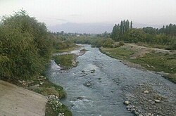 Isfayramsay in the city of Kuvasay Isfayramsay in the city of Kuvasay | |
| Characteristic | |
| Length | 122 km |
| Pool | 2220 km² |
| Water consumption | 21.9 m³ / s ( Uchkurgan village) |
| Watercourse | |
| Source | |
| • Location | Alai Range |
| • Coordinates | |
| Mouth | |
| • Coordinates | |
| Location | |
| Water system | Syrdarya → Small Aral Sea → Large Aral Sea |
| Kyrgyzstan | Batken Oblast , Osh Oblast |
| Uzbekistan | Ferghana region |


Museum of Geology in Tashkent
It originates in the jails of the Alai Range . In the upper reaches, it is called Tengizbay [1] . Flowing north.
The river is part of the Great Ferghana Canal system . In the city of Kuvasay, a canal departs from it. XVII Party Congress [2] , several more channels downstream. East of the village of Kirguli , river water flows into the South Ferghana Canal [3] .
Food is mainly snow-ice. The maximum volume of water falls on May-August - the minimum December-February. The average water discharge near the village of Uchkurgan in Kyrgyzstan (the beginning of an irrigation fan) is 21.1 m³ / s [1] . The average water flow rate is 21.9 m³ / s.
Isfayram during the full-flowing period, mainly in the summer, a turbulent stream with chocolate-colored water due to impurities of sand and clay. The water is very cold. In some places along the banks, small tugai forests were preserved overgrown with shrubs of jida (sucker), sea buckthorn, and others. In 1962 and 1973, serious mud-stone mudflows took place on Isfayram, which led to the evacuation of the city of Kuvasay and the neighboring villages.
Notes
- ↑ 1 2 3 Isfayramsay // Great Soviet Encyclopedia : [in 30 vol.] / Ch. ed. A.M. Prokhorov . - 3rd ed. - M .: Soviet Encyclopedia, 1969-1978.
- ↑ Map sheet K-42-144 Kuvasay . Scale: 1: 100,000. 1978 edition
- ↑ Map sheet K-42-132 of Ferghana . Scale: 1: 100,000. Status of the terrain for 1984. 1988 edition