The island of Cherboli ( Italian: Cerboli ) - a desert island, is privately owned, is the commune of Rio Nell'Elba in the Italian province of Livorno in the Tuscany region.
| Cherboli | |
|---|---|
| ital. Cerboli | |
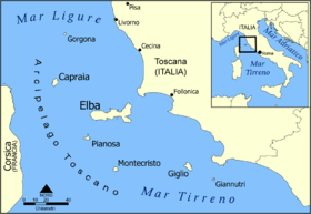 Map of the Tuscan Archipelago | |
| Specifications | |
| Square | 0.04 km² |
| Population | 0 pax (2012) |
| Location | |
| Archipelago | Tuscan archipelago |
| Water area | Strait of corsican |
| A country |
|
| Region | Tuscany |
| Provinces | Livorno |

Content
Geography
The island is irregularly elliptical in shape and has the longest 21 ° nord-nordest axis. (North-North-East) about 600 m, and the smaller in the direction sud-ovest (South-West) about 240 m, with a total area of about seven hectares (68,000 m²). Geographic coordinates of the cadastre, 8600 nord (North), 18300 est (East).
The island is located in the Piombino Strait, 6.4 km east of Cape Capo Pero (Cape Pero or Cavo) on Elba Island, 4 km south of the port of Piombino and 14.5 km west of the port of Punta Ala.
The island is equidistant from the Elbe and the mainland. Being almost in the Gulf of Follonica, the island, in relation to the main centers of the coast of the gulf, is located at the following distances:
- Follonica - 15.3 km.
- Puntone - 16 km.
- Rio Marina - 8 km.
- Porto Azzurro - 16 km.
- Piombino - 6.4 km.
Thus, this island of the Tuscan archipelago is closer to the mainland.
It is clearly divided into two parts, the North, almost untouched part with shrubs and vegetation, almost hanging in the sea, characteristic of the Mediterranean coast. The South-West was exploited; large-scale excavations were carried out during the development of limestone.
Limestone cliffs protrude from the emerald-clear sea, which, thanks to the light current in the middle of the canal, always keeps its waters crystal clear.
The island is also a paradise for geologists, one part (northeast) has a very rare, readable stratigraphic structure.
The island, for the most part, is covered with myrtle thickets, mastic trees and other wild plants.
- "From the Physico-Geographical Dictionary of Tuscany E.Ripetti - Milano 1835"
- "Geographical Dictionary of Tuscany E. Ripetti - Milano 1855 Mineralogy about. Cerboli »
History
The island of Cherboli, due to its solitude, was practically not visited. Corsairs and smugglers found refuge on it. Because Jacob Six (Jacopo VI) agreed with the princes Appiani (Appiani) to build a tower at the highest point of the island (it can be seen now). And he allocated money for the simultaneous construction, opposite the tower, the anchorage.
At one time, the island was a reserve of the archbishops of Pisa for falconry for pheasants which were then bred there. Subsequently, it was handed over by the Pisans to the princes of Piombino, who built a tower on the island of Cherboli, the remains of which now stand among the thickets of myrtle and hawthorn.
- "From the history of the city and state of Piombino - written on the basis of unpublished and rare documents from the fund of Ludovico Cappelletti (Ludovico Cappelletti)"
During World War II, a contingent of the Navy was stationed on Cherboli, some of them lived in an old tower with thick walls; others, as Rina Fernandez recalls, (then a girl), were placed in the guard's house. Sergeant Mario Lenzi from Livorno commanded a small detachment, he lived on the island with his wife and two sons, one of whom was only one year old. Everyone lived as one big family, and everything went in perfect harmony.
Later, the duties of commanding a small detachment of sailors, consisting of 6 military, transferred to the captain of Santa Margarita Ligure drafted into the army. Difficult times did not pass by people on Cherboli, who was attacked by aircraft, who shot him from machine guns from a low height. Some soldiers left Cerboli after the armistice on September 1, 1943, and in civilian boats arrived in Piombino.
Limestone Development
Back in 1927, Bernardino Procchi received an order from the Ministry of the Navy to arrange several artillery positions on the island, due to its important strategic location in the middle of the Piombino Canal. Until that time, Cherboli remained a green island, covered with olive trees and Mediterranean vegetation, inhabited by wild rabbits and small snails with an ancient powerful tower towering above it. Prokchi completed the construction of the position, but in the course of work, he discovered that the rocks of the island consist of the type of limestone that is very suitable for the production of steel and cement. Therefore, he decided to take an initiative to develop and supply Piombino with iron and steel industry. Earthwork was carried out effectively at Cherboli created an open pit. Large boulders were broken by hammer blows, then loaded into trolleys similar to those used in the Elbe mines and then dumped into bunkers located in three different parts of the island: one in the west, one in the north and one in the southwest in various conditions of sea weather. The bunker in the West was called “under the house”, the second southwest “wormhole” because it was the smallest, the third “Tramontana” was named after the north wind. Barges, brought in by tugs, to a parking lot under the bunker and limestone loading took place in a short time. Then, they were towed to Piombino for unloading and remained there until the next flight. Up to 45 people worked at Cherboli, as well as sea transport workers, on the island they were provided with everything necessary. Living quarters, food. Initially, the canteen was run by Giuseppe Belli, when he emigrated to Australia, she transferred to his wife Franzosi. Electricity was generated with the help of generators; there was also an oven for bread, a tank, where rainwater was collected, which was mixed with the one brought by tugboats.
This type of limestone is still present in large quantities on the island, if you again evaluate its presence in piles scattered around sites and in the immediate vicinity of buildings, you will find a large amount of material strong enough and suitable for use in all types of construction.
Buildings and Dwellings
Two buildings that remain in good condition are called: the Tramontana bunker (tramoggia di Tramontana) and the East (di ponente), their vertical walls go straight into the sea. They accumulated and stored material extracted at appropriate points on the island for loading directly onto barges that delivered it to Piombino. These buildings are perfectly preserved, as they are built from very thick blocks and can be restored (without changing their appearance) for any use.
The third bunker, which was present in the south, did not withstand the blows of time, the sea, numerous vandals who used the island for exercises with explosives, etc. However, previously there was a tunnel that connected the South and West bunkers, then it was blown up and currently does not exist, although clearly visible in some photographs of that time.
On the top of the island at an altitude of about 80 m above sea level, there is a lower tier of a fortified watchtower (walls of considerable thickness) in time, it dates from the period of the Renaissance, presumably 600 years, with subsequent changes in the thickness of walls, buttresses and the construction of an external staircase, dating back to World War I
This building, which gives an accurate visual definition of the silhouette of the entire island, is built with an internal brick vault. The facade of the tower is dangerously close to the edge of the limestone mine, an almost vertical wall about 80 meters high.
All constructed communications of the island, trails, roads, sites, marinas and buildings were abandoned. However, they remain practically untouched by time and sea. The stone walls on the outer sides of the island were intended for the accumulation and subsequent loading of the extracted materials onto barges. These three structures are located in different directions, North, South and West. The buildings in the north and west are well preserved, while the south ones were destroyed and there are only traces. The thick walls of the stone blocks of the quarry were thus not damaged.
Moorings
Initially, there were three piers located on three sides of the island, even with a raging sea conditions always allow you to moor from the leeward side of the island, the shape of which is excellent protection from strong side winds.
Two mooring piers are practically in working condition and only the works necessary as part of the extraordinary maintenance are needed. The pier in the north served the isolated Tramontana quarry, the other in the west served the most important western quarry. The latter, called "under the house," all the time served as the most convenient for mooring and connected to the only road leading to a wide area.
Regattas
The island is a "turning buoy" during the deep-sea regattas organized by the Rio Marina and Castiglone della Pescaia sailing centers. This unchanging Signal Point has never been disputed by any of the riders.