Putilovskaya embankment - embankment on the Kanonersky island in the Kirovsky district of St. Petersburg . It runs along the shore of the Sea Channel along residential buildings.
| Putilovskaya Embankment | |
|---|---|
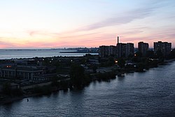 General view of Kanonersky island and Putilovskaya embankment | |
| general information | |
| A country | Russia |
| City | St. Petersburg |
| Area | Kirovsky |
| Historical district | Gunner island |
| Length | ≈ 1.1 km |
| Underground | |
History
The driveway that formed along the island’s residential buildings along the shore of the Sea Canal, on September 21, 2009, received the name Putilovskaya Embankment , in honor of the Russian mathematician, engineer and entrepreneur N. I. Putilov .
As of October 2014, Putilovskaya Embankment is the only named roadway on Kanonersky Island. However, despite the naming of the embankment, the numbering of the houses remained the same, that is, along the Gunner Island.
Transport
The metro station closest to Putilovskaya Embankment is Narvskaya
The commercial bus routes No. K19, K66, K67 and K115 run along the promenade from house No. 23 to house No. 10 on Kanonersky Island.
Literature
- Architects of St. Petersburg. XX century / comp. V. G. Isachenko ; ed. Yu. Artemyev, S. Prohvatilova. - SPb. : Lenizdat , 2000 .-- 720 p. - ISBN 5-289-01928-6 .
- Vladimirovich A. G. , Erofeev A. D. Petersburg in the names of the streets. - M .: AST; SPb. : Astrel-SPb; Vladimir : VKT, 2009 .-- 752 p. - 3000 copies. - ISBN 978-5-17-057482-7 .