Lomovatka is a village in the Veliky Ustyug district of the Vologda region . The administrative center of the Lomovatsky rural settlement and the Lomovatsky Village Council [1] .
| Village | |
| Scrap | |
|---|---|
| A country | |
| Subject of the federation | Vologodskaya Oblast |
| Municipal district | Veliky Ustyug district |
| Rural settlement | Lomovatskoe |
| History and geography | |
| Climate type | moderate continental |
| Timezone | UTC + 3 |
| Population | |
| Population | ▼ 1141 people ( 2010 ) |
| Nationalities | Russians |
| Digital identifiers | |
| Postcode | 162365 |
| OKATO code | 19214820001 |
| OKTMO code | |
| Other | |
| Reg. number | 991 |
Lomovatka is located in the northeast of the Vologda region, on the branch of the Northern Konosha - Kotlas railway . The nearest town is the Great Erogodskiy Pochinok . To the west of Lomovatka are the village of Abramovsky Pochinok and the Archangel settlements of Sengoss and Kizema , to the east - the settlements of Yorga and Udimsky . The settlement is connected to the road network by a departmental road with a coating of reinforced concrete slabs. The distance to the district center Veliky Ustyug by road - 110 km.
The village of Lomovatka was formed on the site of the barracks built by GULAG prisoners during the construction of the North-Pechora railway in the 1940s. In 1954, logging operations began, in 1958 the Lomovatsky timber industry enterprise was established. In 1960, the Lomovatsky Rural Council was formed, in 2006 - the Lomovatsky rural settlement . In 1992, the timber industry enterprise was incorporated, in 2002, Lomovatka-Les LLC was established on the basis of its property complex.
The population of the village, according to the 2010 census , was 1,141 people. According to the 2002 census , there were 1,513 people in the village (710 men, 803 women). The predominant nationality is Russians (94%) [2] .
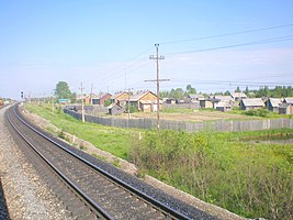
View of the village from the railway
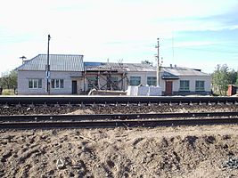
Station station Lomovatka

House in Lomovatka


Notes
- ↑ The Law of the Vologda Oblast of 06.12.2004 No. 1109-OZ “On Establishing the Borders of the Veliky Ustyug Municipal District, the Borders and the Status of the Municipal Formations That Are Part of It”
- 2002 2002 census data: table 2C. M .: Federal State Statistics Service, 2004.
Links
- On the edge of the earth
- Chunkie (inaccessible link) in the register of settlements of the Vologda region
- The narrow gauge railway in Lomovatka on the site about the railway