Yodo [1] [2] [3] ( 淀 川 Yodo-gawa , Yodo-gawa [4] ) is the main river of Osaka Prefecture on Honshu Island, Japan . The length of the river is 75.1 km, the basin area is 8240 km².
| Iodo | |
|---|---|
| jap. 淀 川 | |
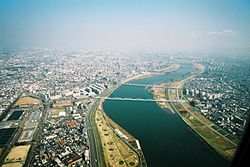 Iodo in northern Osaka Iodo in northern Osaka | |
| Characteristic | |
| Length | 75 km |
| Pool | 8240 km² |
| Watercourse | |
| Source | Biwa |
| • Location | Otsu |
| • Height | 85 m |
| Mouth | Osaka Bay |
| • Location | Osaka |
| • Height | 0 m |
| • Coordinates | |
| Location | |
| A country |
|
| Regions | Osaka , Shiga , Kyoto |

The only river flowing from the southern part of Lake Biwa in the city of Otsu , the administrative center of Shiga Prefecture . The height of the source is 85 [5] m above sea level. Beginning as the Seta River ( 瀬 田 川 Seta Gava , Seta Gava [4] ) , it successively changes its name to Uji ( 宇 治 ава 川 Uji-gava , Uji-Gava [4] ) and then to Yodo itself: it is named after the confluence of Uji with the rivers Katsura ( 桂 川 Katsura-gava ) and Kizu ( Japanese 木 津 川 Kizu-gawa ) in the border area of Kyoto and Osaka prefectures. It flows into the Gulf of Osaka within the boundaries of the city of Osaka .

The main channel within the boundaries of the prefectures of Shiga, Kyoto and Osaka is classified according to the system adopted in Japan as a river of the first category . The number of feeding tributaries and rivers flowing into Lake Biwa is 965: for this indicator, Iodo ranks first in Japan.
River water is used for irrigation and in hydropower.
Notes
- ↑ Central Japan // Atlas of the World / comp. and preparation. to the ed. PKO "Cartography" in 1999; open Ed .: T.G. Novikova , T.M. Vorobyova . - 3rd ed., Eras., Fr. in 2002 with diaposes. 1999 - M .: Roskartografiya, 2002. - P. 144. - ISBN 5-85120-055-3 .
- ↑ Iodo // Dictionary of geographical names of foreign countries / resp. ed. A.M. Komkov . - 3rd ed., Revised. and add. - M .: Nedra , 1986.- S. 139.
- ↑ Great Russian Encyclopedia : [in 35 vols.] / Ch. ed. Yu.S. Osipov . - M .: Great Russian Encyclopedia, 2004—2017.
- ↑ 1 2 3 Map sheet I-53-44 Osaka . Scale: 1: 100,000. Status of the area in 1966. 1971 Edition
- ↑ Map sheet I-53 . Scale: 1: 1,000,000 .