Lajari [1] ( Urdu کونړ سيند ) is a small river flowing through the Pakistani metropolis of Karachi from the north-east through the entire city center and flowing into the Arabian Sea off the small peninsula of Manor . The length of the river is about 50 kilometers. Being a seasonal river, Layari serves as a catchment during the rainy season. [2]
| Layari | |
|---|---|
| Urdu دریائے لیاری | |
| Characteristic | |
| Length | 50 km |
| Watercourse | |
| Mouth | Arabian Sea |
| • Height | 0 m |
| • Coordinates | |
| Location | |
| Water system | Arabian Sea |
| A country |
|
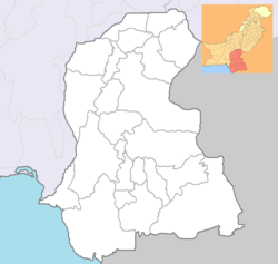
| Region | Sindh |
| Area | Karachi |
Content
- 1 History
- 1.1 Lari Expressway
- 2 River pollution
- 3 See also
- 4 notes
- 5 Links
History
Until the 1950s, the river was clean and abundant in fish; along the banks, agriculture was carried out. [3] But after Pakistan gained independence in 1947, when Karachi proclaimed the capital of the new state, the population of the city began to grow rapidly due to immigrants from India and internal migration. Because of this and economic growth, the development of industry, the river changed its purpose: it began to fulfill the role of wastewater.
Unregulated settlement of the surroundings along the river began to lead to human and material losses during the rise of the river level. So, after the devastating flood that happened in 1977, the need arose to build protective dams along the entire river. Despite this, floods occurred in the 1990s. In 1986, a project was proposed for a motorway through a city running along the banks of the river, but was delayed due to the need, if implemented, to relocate about 100,000 people. [four]
Layari Expressway
However, the implementation of the 16.5-kilometer highway project began in 2002 without any public consensus, as a result, many buildings were demolished under the pretext of the illegality of their construction. About 200,000 families were relocated to new areas and suburbs of Karachi. [5] . The new highway became an alternative to the existing bypass highway and helped to slightly relieve the center.
River Pollution
A large number of industrial enterprises are located along the river, dumping untreated waste into the Layari sewage. [6]
See also
- Layari
Notes
- ↑ Map sheet G-42-B .
- ↑ S Nazneen and F Begum (1988) Hydrological studies of Lyari River. Pakistan Journal of Scientific and Industrial Research. Vol. 31, No. 1, pp. 26-29.
- ↑ R Asif (2002), Lyari Expressway: woes of displaced families . Dawn (newspaper) . 8 August. Retrieved on 10 January, 2008
- ↑ Z Mustafa (2006), Lyari Expressway: Boon or Bane , Dawn (newspaper) . March 8, 2006. Retrieved on January 10, 2008
- ↑ A Hasan (2005), The political and institutional blockages to good governance: The case of the Lyari expressway in Karachi , Environment and Urbanization, Vol. 17, No. 2, pp. 127-141
- ↑ JE Hardoy, D Mitlin, D Satterthwaite (1993), The Environmental Problems of Third World Cities. Earthscan . ISBN 978-1-85383-146-1
Links
- IUCNP - IUCN 's website on environmental issues and Biodiversity of Pakistan
- Pakistan Fisherfolk Forum on Marine pollution