The White Sea ( Karelian. Vienanmeri , nen. Serako Yamʼ , until the 17th century Studenoye, Solovetsky, Northern, Calm, White Bay [1] ) - the inland sea in the north of the European part of Russia , belongs to the Arctic Ocean .
| White Sea | |
|---|---|
| Karelian Vienanmeri , nen. Seraco Yamʼ | |
 | |
| Characteristics | |
| Area | 90.8 thousand km² |
| Volume | 4.4 thousand km³ |
| Coastline | not less than 2000 km |
| Deepest | 343 m |
| Average depth | 67 m |
| Location | |
In Scandinavian mythology, the White Sea is known as Gandvik ; also known as “Snake Bay” due to the curved coastline [2] .
Content
- 1 Physical location
- 2 Sea bottom relief
- 3 Hydrological regime
- 4 Temperature and salinity
- 5 Winds
- 6 History
- 7 Economics
- 7.1 Commercial fishing
- 8 Reflection in art
- 9 In philately
- 10 notes
- 11 Literature
- 12 Links
Physical location
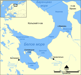
Among the seas washing Russia, the White Sea is one of the smallest (smaller - only the Sea of Azov ). Its surface area is 90 thousand km² (with numerous small islands, among which the Solovetsky Islands are the most famous - 347 km²), that is, 1 ⁄ 16 of the Barents Sea area , the volume is only 4.4 thousand km³ . The longest stretch of the White Sea from Cape Kanin Nos to Kemi is 600 km .
The greatest depth of the sea is 343 meters , the average is 67 meters .
The boundary between the White and Barents Seas is considered to be a line drawn from Cape Svyatoy Nos ( Kola Peninsula ) to Cape Kanin Nos ( Kanin Peninsula) [3] .
Large rivers Kem , Mezen , Onega , Ponoi , Severnaya Dvina and many small rivers flow into the White Sea.
Main ports: Arkhangelsk , Belomorsk , Kandalaksha , Kem , Mezen , Onega , Severodvinsk .
The White Sea-Baltic Canal connects the White Sea with the Baltic and the Volga-Baltic Waterways .
The entire White Sea is entirely the inland waters of Russia .
The White Sea water area is divided into several parts: Basin , Throat (the strait connecting the White Sea with the Barents; the White Sea throat is called “Girlo” by pomors, this word is quoted in this story in its story “Sealed Glory” by B. V. Shergin ), Funnel , Onega Bay , Dvinskaya Bay , Mezen Bay , Kandalaksha Bay . The shores of the White Sea have their own names and are traditionally divided (in counterclockwise order from the coast of the Kola Peninsula) into Tersky , Kandalaksha , Karelian , Pomeranian , Onega , Summer , Winter , Mezensky and Kaninsky ; sometimes the Mezensky coast is divided into the Abramovsky and Konushinsky coasts , and part of the Onega coast is called the Lyamitsky coast .
The seashore (Onega and Kandalaksha bays) are cut by numerous lips and bays . The western banks are steep, the eastern ones are low. The entire coast of the White Sea belongs to the land territories of the Arctic zone of the Russian Federation [4] .
Seabed relief
A large sandbank in the northern part of the sea with depths of up to 50 meters in the Dvina and Onega bays passes into a slope, and then into a depression in the central part of the sea with depths of 100-200 meters and a maximum depth of 340 meters ( ).
The central part of the sea is a closed basin , separated from the Barents Sea by a threshold with shallow depths that impede the exchange of deep waters.
Bottom sediments in shallow water and in the Throat consist of gravel , pebbles , sand , sometimes - shell rock . The bottom in the center of the sea is covered with fine-grained clay silt of brown color .
Geologists discovered ferromanganese nodules at the bottom of the sea.
Hydrological regime
The hydrological regime of the sea is affected by climatic conditions, water exchange with the Barents Sea, tidal phenomena, river flow and bottom topography.
The tidal wave from the Barents Sea has a semidiurnal character. The average altitude of the syzygy tides ranges from 0.6 ( Zimnaya Zolotitsa ) to 3 meters ; in some narrow bays it reaches 7 meters ( 7.7 meters in the Mezen Bay , the mouth of the Syomzha River). A tidal wave penetrates upstream of rivers flowing into the sea (in the Northern Dvina, up to 120 kilometers ).
Despite the small surface area of the sea, storm activity is developed on it, especially in autumn, when during storms the wave height reaches 6 meters .
The overtaking phenomena in the cold season reach 75–90 centimeters at sea.
Every year for 6-7 months the sea is covered with ice . Fast ice forms along the coast and in the bays, the central part of the sea is usually covered with floating ice reaching a thickness of 35-40 centimeters , and in severe winters up to one and a half meters.
Temperature and salinity
The temperature of the surface layer of sea water varies greatly depending on the season in different parts of the sea. In summer, the surface waters of the bays and the central part of the sea warm up to 15–16 ° C , while at the same time in the Onega Bay and Gorla it does not exceed 9 ° C. In winter, the temperature of surface waters drops to −1.3 ... -1.7 ° C in the center and in the north of the sea, in bays - to −0.5 ... -0.7 ° C.
| Horizon m | January | February | March | April | May | June | July | August | September | October | November | December |
| 0 | -0.3 | -0.3 | -0.3 | -0.2 | 3,1 | 9.0 | 13,4 | 13.8 | 8.9 | 4.7 | 2.5 | 0.2 |
| 10 | -0.8 | -1.2 | -1.2 | -0.7 | 1.9 | 6.0 | 11.1 | 12.6 | 8.2 | 5,0 | 2.9 | 1,2 |
| twenty | -0.4 | -0.8 | -0.9 | -0.7 | 0.9 | 3.4 | 4.8 | 7.8 | 5.3 | 4.7 | 3.0 | 1,6 |
| thirty | -0.2 | -0.6 | -0.7 | -0.6 | 0.5 | 1.8 | 2.1 | 3.4 | 3.8 | 3.9 | 3.0 | 1.7 |
| fifty | 0.2 | -0.1 | -0.6 | -0.6 | 1.7 | 0.5 | 0.5 | 1,6 | 2.0 | 2.7 | 2.7 | 1.9 |
| Water temperature (data for 1977-2006) | |||||||||||||
|---|---|---|---|---|---|---|---|---|---|---|---|---|---|
| Indicator | Jan | Feb | Mar | Apr | May | Jun | Jul | Aug | Sep | Oct | But I | Dec | Year |
| Absolute maximum, ° C | 0,0 | 0,0 | 0,0 | 5,4 | 17.6 | 25.5 | 26.5 | 26.7 | 18.2 | 12,4 | 4.2 | 1.3 | 26.5 |
| Average temperature, ° C | 0,0 | 0,0 | 0,0 | 0.1 | 6.4 | 15.4 | 19,2 | 16.6 | 10.6 | 4.0 | 0.4 | 0,0 | 4.8 |
| Absolute minimum, ° C | 0,0 | 0,0 | 0,0 | 0,0 | 0,0 | 6.9 | 12.1 | 8.9 | 3,5 | 0,0 | 0,0 | 0,0 | 0,0 |
| Source: ESIMO | |||||||||||||
The deep water layers (below a depth of 50 meters) have a constant temperature, regardless of the season, from −1.0 ° C to +1.5 ° C, while in the Throat, due to intense tidal turbulent mixing, the vertical temperature distribution is uniform.
The salinity of sea water is associated with the hydrological regime. A large inflow of river waters and a slight exchange with the Barents Sea led to a relatively low salinity of the surface sea waters ( 26 ppm and lower). The salinity of deep waters is much higher - up to 31 ppm . Desalinated surface water moves along the eastern shores of the sea and flows through the Throat to the Barents Sea, from where more saline water flows along the western shores to the White Sea. In the center of the sea, a counter-clockwise circular flow is observed.
Winds
Belomorsky winds have their own names:
- siverko, north - north wind;
- midnight, seaman - northeast;
- lunch - southeast;
- noon, summer - southern;
- Shelonik, pauzhnik (in Mezen ) - southwestern;
- the depths, golomyanik - northwest [6] .
History
The sea was known to the Novgorodians at least from the 11th century. The sea was of great importance for trade navigation, and the surrounding forests were rich in fur-bearing animals, because these places quickly developed. One of the earliest Russian settlements near the coast was the Kholmogory Mountains on the Northern Dvina founded in the 14th century. From there, in 1492, a merchant fleet, loaded with grain and having on board the ambassadors of Ivan III, set off for Denmark, marking the appearance of the first Russian international seaport.
The first foreign ship to arrive in the White Sea was the English ship Eduard Bonaventure, commanded by Richard Chancellor . Together with two other ships under the command of Hugh Willoughby, they searched for the northern route to India. The expedition was equipped with King Edward VI and a group of about 240 English merchants and was authorized to establish trade relations. Willoughby's ships were divided into the sea, and two of them, together with the head of the expedition, died in unclear circumstances. However, Bonaventure managed to enter the White Sea and reach Kholmogor, from where Richard Chancellor travels to Moscow to Tsar Ivan the Terrible . Returning from Russia in 1554, Chancellor carried a detailed description of Moscow and the Russian North , which were little known to Europe, as well as a letter from the tsar with a desire to establish trade relations with England. In Moscow, a Moscow company was established, the purpose of which was to trade with Russia on the White Sea.
After the British, the Dutch followed, and soon the Kholmogory turned into an important point in the sale of fur and fish. In the city, both foreigners and Russians created benches and trading posts. A fortress was built in the port, which withstood the siege of the Polish-Lithuanian army in 1613. The increase in cargo turnover led to the reloading of the port, which stood on the river, and therefore had restrictions on tonnage and draft. As a result, in the delta of the Northern Dvina in 1584, the city of New Kholmogory appeared, later renamed Arkhangelsk .
Until the beginning of the XVIII century, the majority of Russian trade routes passed through the White Sea, but this was not very convenient, since the White Sea was covered with ice for more than six months. After the founding of St. Petersburg, the flow of goods decreased significantly, the main sea trade routes moved to the Baltic Sea. Since the 1920s, most shipments have been diverted from the White Sea to the ice-free port of Murmansk , located on the shores of the Barents Sea .
Economics
Industrial Fisheries
In the White Sea, industrial fishing is carried out. According to the results of 2017, 1964 tons of fish and other types of aquatic biological resources were caught in its water area. For comparison, in 2016 the catch amounted to 2946 tons [7] .
Reflection in Art
- The development of the White Sea and the mouth of the Northern Dvina by the Novgorodians in the 9th century and their clash there with nurmans ( Vikings ) is the subject of the historical novel by Soviet writer V. D. Ivanov “Tales of Ancient Years” (1955).
- The film " Pavel Lungin " Island " takes place in a monastery on the islands of the White Sea.
- Soviet animated film "Laughter and Woe at the Bela Sea" based on the tales of Boris Shergin and Stepan Pisakhov .
- Documentary film by Dmitry Vasyukov “Pomory”.
- The main action of the feature film "Young Russia" (directed by I. Gurin, based on the novel of the same name by Y. German) takes place on the White Sea coast.
In philately
- Postage stamps of Russia , 2005: lighthouses of the White Sea
Mudyugsky lighthouse
Solovetsky lighthouse
Svyatosnos lighthouse
Notes
- ↑ White Sea // Kola Encyclopedia . In 5 t. T. 1. A - D / Ch. ed. A.A. Kiselev . - SPb. : IP; Apatity: KSC RAS, 2008 .-- S. 306.
- ↑ “Northern Scandinavia during the Middle Ages”, part of “In honorem Evert Baudou” (1985), Sven Lundkvist
- ↑ Limits of Oceans and Seas (Special Publication No. 23) : [ eng. ] : [ arch. April 17, 2013 ] / International Hydrographic Organization . - 3rd edn. - Monte-Carlo : Imp. Monégasque, 1953.- 39 p.
- ↑ Decree of the President of the Russian Federation of May 2, 2014 No. 296 “ On land territories of the Arctic zone of the Russian Federation ” (with amendments and additions).
- ↑ ESIMO (inaccessible link) . Archived August 21, 2011.
- ↑ Prokh L.Z. Dictionary of the winds. - L .: Gidrometeoizdat, 1983. - S. 46. - 28,000 copies.
- ↑ Information on the catch of fish, the extraction of other aquatic biological resources and the production of fish products for January - December 2017
Literature
- Voeikov A.I. White Sea // Encyclopedic Dictionary of Brockhaus and Efron : in 86 volumes (82 volumes and 4 additional). - SPb. , 1890-1907.
- Pilot of the White Sea. 1913 / Ed. Chap. Hydrograph. Control Pestilence. M-va. - Petrograd: Printing house of the Ministry of the Sea, 1915. - 1035 p.
- Leonov A.K. Regional Oceanography. - L .: Gidrometeoizdat , 1960.
- Shamraev Yu. I. , Shishkina L.A. Oceanology: a textbook for hydrometeorol. technical schools / Ed. A.V. Nekrasov, I.P. Karpova. - L .: Gidrometeoizdat , 1980 .-- 382 p.
- Tsetlin, A. B. Flora and Fauna of the White Sea: Illustrated Atlas / Ed. Zhadan A.E., Marfenin N.N. - M .: T-number of scientific publications of KMK, 2010. - 471 p. - ISBN 978-5-87317-672-4 .
- Naumov A.D., Fedyakov V.V. Eternally Alive White Sea . - SPb. : Publishing House of the St. Petersburg Mountains. Palace of Youth Creativity, 1993. - 335 p. - ISBN 5-88494-064-5 .