Shalinsky is a village in the Krasnoyarsk Territory , the administrative center of the Mansky District and the Shali Village Council . It was founded in the middle of the 18th century .
| Village | |
| Shali | |
|---|---|
 | |
| A country | |
| Subject of the federation | Krasnoyarsk region |
| Municipal district | Mansky |
| Rural settlement | Shali Village Council |
| History and geography | |
| Timezone | UTC + 7 |
| Population | |
| Population | ↘ 3932 [1] people ( 2010 ) |
| Digital identifiers | |
| Telephone code | +7 39149 |
| Postcode | 663510 |
| OKATO code | |
| OKTMO code | |
Geography
The village is located in the northern outskirts of the eastern Sayan Mountains between the Shalinka rivers and the Kamenny stream before they flow into Esaulovka at an altitude of about 380 meters above sea level. It is territorially stretched along the Shalinka river.
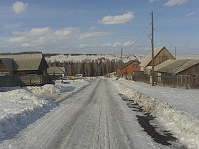
Shalinskoye village from a height of 100 meters.
Population
| Population | ||||||
|---|---|---|---|---|---|---|
| 1939 [2] | 1959 [3] | 1970 [4] | 1979 [5] | 1989 [6] | 2002 [7] | 2010 [1] |
| 2970 | ↗ 3477 | ↗ 4058 | ↗ 4092 | ↗ 5115 | ↘ 4264 | ↘ 3932 |
Transportation
- The road 04K-029 Sayany ( Minusinsk - Kuskun ) passes through the village, having access to the P255 Siberia highway (877 km) 30 km from the village.
- 5 km from the village is located Mansky airfield, serving the An-2 and Yak-52 aircraft of the Krasnoyarsk Aviation Sports Club DOSAAF .
- 12 km north of the village is the Kamarchaga railway station (4,178.5 km of the Trans-Siberian Railway, section Zykovo - Uyar ).
Notes
- ↑ 1 2 The 2010 All-Russian Population Census. Results in the Krasnoyarsk Territory. 1.10 The population of urban areas, mun.rayonov, mountains. and sat down. settlements and settlements . The appeal date is October 25, 2015. Archived October 25, 2015.
- All-Union census of 1939. The number of rural population of the USSR in areas, large villages and rural settlements - the regional centers . The date of circulation is January 2, 2014. Archived January 2, 2014.
- All-Union census of 1959. The population of the rural population of the RSFSR — inhabitants of rural settlements — district centers by sex
- ↑ 1970 All-Union Population Census. The population of the rural population of the RSFSR - the inhabitants of rural settlements - regional centers by gender . The date of circulation is October 14, 2013. Archived October 14, 2013.
- ↑ 1979 All-Union Population Census. The population of the rural population of the RSFSR - residents of rural settlements - district centers . The appeal date is December 29, 2013. Archived is December 29, 2013.
- All-Union Population Census 1989. The population of the rural population of the RSFSR — inhabitants of rural settlements — district centers by sex . Circulation date November 20, 2013. Archived November 16, 2013.
- ↑ All-Russian census of 2002. Tom. 1, table 4. The population of Russia, federal districts, constituent entities of the Russian Federation, districts, urban settlements, rural settlements — regional centers and rural settlements with a population of 3,000 or more . Archived on February 3, 2012.