Map of Banat Krajina
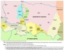
Banat Krajina ( Serb. Banatsk Krajina ) is a part of the Military Border in the territory bordering the Ottoman Empire , located in Banat and Bachka . Currently Banat Krajina is divided between Serbia and Romania . A military organization in the area was introduced by the Austrian authorities in 1718 . In 1751, Maria Theresa demilitarized the northern part of the Banat Krajina, while its southern part was part of the Military Krajina until its abolition. Banat Krajina was divided into three regiments - German, Serbian and Romanian. Its structure included such cities as Pancevo , Bela Tsrkva , Titel , Zhabal , Alibunar , Kovin , etc.
See also
- Banat
- Military border