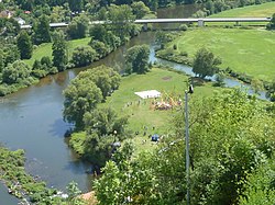
Vils ( German: Vils ) - a river in Germany , flows through the land of Bavaria , the right tributary of the Nab . River index 148 [1] .
| Phils | |
|---|---|
| him. Vils | |
 Fils Estuary Fils Estuary | |
| Characteristic | |
| Length | 87.35 km |
| Swimming pool | 1238.74 km² |
| Watercourse | |
| Source | |
| • Location | Freyung |
| • Height | 453 m |
| • Coordinates | |
| Mouth | Nab |
| • Location | Kallmünz |
| • Height | 338 m |
| • Coordinates | |
| Location | |
| Water system | Nab → Danube → Black Sea |
| A country |
|
| Region | Bavaria |

It originates in the Freyung community ( Amberg-Sulzbach district ) [2] . It falls into Nab in the community of Kallmünz ( Regensburg district) [3] .
The length of the river is 87.35 km. The catchment area is 1238.74 km² [1] .
The height of the source is 453 m [2] . The height of the mouth is 338 m [3] .
Water system: Nab → Danube → Black Sea .
Literature
- Franz Xaver Bogner: Das Tal von Vils und Lauterach . Luftbildband. Pustet, Regensburg 2001, ISBN 3-7917-1755-3 .
Notes
Links
- Naturnaher Umbau der Vils im südlichen Stadtgebiet von Amberg
- Ökologischer Ausbau und vorbeugender Hochwasserschutz
- Seite zum Vilstalwanderweg auf www.bayerischerjura.de
- Seite zum Vilstalwanderweg auf www.amberg-sulzbacher-land.de
- Vilstalwanderweg - Eine Wanderung von der Quelle bis zur Mündung (PDF, 2.18 MB)