De Witt ( English De Witt Island ) - an island off the southern coast of the island of Tasmania ( Australia ), is part of the state of Tasmania . The area of the island is 5.16 km² [1] . Sometimes another name for this island is used - Big Witch ( English Big Witch ). The island is part of the South West National Park [1] .
| De witt | |
|---|---|
| English De witt island | |
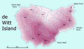 Map of De Witt Island | |
| Specifications | |
| Square | 5.16 km² |
| Highest point | 363 m |
| Population | |
| Location | |
| Water area | Indian Ocean |
| A country |
|
| Region | Tasmania |


Geography
De Witt Island is located about 6 km from the southern coast of Tasmania and is the largest island of the “ Matsiker Island Group ” ( Maatsuyker Island Group ), which, in addition to it, include the Matsiker Island, Flat Witch Island ), Walker ( Walker Island ) and others [2] [3] .
The highest point of the island of De Witt - 363 m [4] .
History
Tasmanian aborigines from ancient times visited this island to hunt fur seals [1] .
The island was named by the Dutch navigator Abel Tasman on November 25, 1642, in honor of Gerrit Frederikszoon de Witt, one of the members of the Batavian Council who sponsored the Tasman expedition [5] . This island is mentioned in the logbook of December 1, 1642 [6] .
Currently, the island is visited by kayakers, sailors and researchers. There were filmed some films [1] [7] .
Fauna
On the island there are small penguins , thin-billed petrels (and other petrels), snow whale birds , Australian gulls , Australian magpie sandpipers and other birds [1] .
Of the mammals on the island, Australian marsh rats ( Rattus lutreolus ), three-toed rats of potor ( Potorous tridactylus ) and Tasmanian philander are found [1] .
See also
- Tasmania
- Matsiker Island
- South West National Park
Notes
- ↑ 1 2 3 4 5 6 Small Southern Islands Conservation Management Statement 2002 (PDF). Tasmania Parks and Wildlife Service, www.parks.tas.gov.au (2002). Date of treatment July 20, 2006. Archived August 22, 2006.
- ↑ South and West Islands (link not available) . www.discovertasmania.com. Date of treatment December 22, 2012. Archived January 25, 2013.
- ↑ Topographic map of Tasmania - De Witt Island . topomapper.com. Date of treatment December 22, 2012. Archived January 30, 2013.
- ↑ LISTmap (De Witt Island) (inaccessible link) . Tasmanian Government Department of Primary Industries and Water. Date of treatment December 22, 2012. Archived January 30, 2013.
- ↑ Dutch Exploration: Dutch names on the Australian Coastline (link not available) . www.australiaforeveryone.com.au. Date of treatment April 24, 2013. Archived on April 29, 2013.
- ↑ Abel Janszoon Tasman's Journal . Project Gutenberg of Australia - gutenberg.net.au. Date of treatment December 22, 2012. Archived January 30, 2013.
- ↑ De Witt Island 7001 . www.enhancetv.com.au. Date of treatment April 22, 2013. Archived April 29, 2013.