The Volga-Baltic Waterway (in the years 1810-1963 - the Mariinsky Water System ) is a system of canals, rivers and lakes in the north-west of the Russian Federation , connecting the basins of the Caspian and Baltic seas. Passes through the Rybinsk reservoir to the city of Cherepovets , p. Sheksna , White Lake , r. Kovzha , Mariinsky Canal , r. Vytegra , Onega Canal , Lake Onega , p. Svir , Lake Ladoga and r. Neva The Mariinsky water system was built in 1799-1810, rebuilt in 1890-1896, after a radical reconstruction in 1964 it received its modern name. The route length is approximately 1100 km, the depth of the navigable channel is not less than 4 m, which ensures passage of vessels with a displacement of up to 5000 tons. A continuation of the Volga-Baltic route is the White Sea-Baltic Canal connecting Lake Onega with the White Sea .
| Volga-Baltic waterway | |
|---|---|
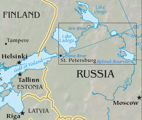 Volga-Baltic waterway. Map. | |
| Location | |
| A country |
|
| Subjects of the Russian Federation | Yaroslavl region , Vologda region , Leningrad region , St. Petersburg |
| Characteristic | |
| Length | 1100 km |
| Watercourse | |
| Head | Volga |
| · Head location | Rybinsk reservoir |
| Mouth | The Gulf of Finland |
| · Location of the mouth | St. Petersburg |

Content
- 1 History of creation
- 1.1 Mariinsky system
- 1.2 Mariinsky system in 1917-1953
- 1.3 Resumption of construction on a new project
- 2 Description
- 2.1 Hydro facilities of the Volga-Balta
- 2.2 Shipping
- 3 Flooded villages
- 4 Status and development prospects
- 5 See also
- 6 notes
- 7 Literature
- 8 Sources
- 9 References
Creation History
Russia's access to the Baltic Sea at the beginning of the 18th century, the growing role of St. Petersburg, required convenient water communications of the new capital with the interior of the country. Three waterways were created - the Vyshnevolotsk water system (movement opened in 1709), Tikhvin (1811) and Mariinskaya (1810).
Mariinsky system
The route of the Mariinsky water system connected Rybinsk , Sheksna , White Lake , Kovzhu , Mariinsky (since 1886 - the Novo-Mariinsky replaced it) canal, laid through the watershed between the basins of the Caspian and Baltic Seas, Vytegra , Lake Onega , Svir , Lake Ladoga and Neva (about 1054 miles). The Mariinsky system itself was part of the route from the Volga to Lake Onega. In 1829, the North Dvina Canal was opened, connecting Sheksna and Lake Kubenskoye . He connected the system through Sukhona and the Northern Dvina with the White Sea . For safer sailing of small vessels along the White, Onega and Ladoga lakes, bypass channels were laid - Belozersky, Onega, Novo-Svirsky, Novo-Syassky and Novo-Ladozhsky. For its time, the Mariinsky system was an outstanding hydraulic engineering structure and was of great economic importance, but, despite the reconstruction carried out in 1890-1896, it no longer met the country's transport needs.
Mariinsky system in 1917-1953
- 1922 - opening of the Cherepovets hydroelectric complex (gateway No. 40);
- 1926 - opening of the Cherepanovsky hydroelectric complex (gateway No. 41);
- 1930 - opening of the Yagorb hydroelectric complex (gateway No. 42);
- 1933 - opening of the Nizhne-Svirsky hydroelectric complex ;
- September 24, 1940 the Central Committee of the CPSU (b) and the Council of People's Commissars of the USSR adopted a resolution on the construction of the Volga-Balt;
- In the spring of 1941, the filling of the Rybinsk reservoir began (pressure 18 m), the flooding of locks No. 39–42;
- 1947 - resumption of work after World War II. Under the Ministry of Internal Affairs of the USSR, the management of Glavgidvolgobaltstroy was created;
- The architectural processing of the structures was developed by the employees of the Leningrad branch of the Hydroproject under the leadership of L. M. Polyakov in 1952-1953; co-authors: L. M. Banshchikov, A. I. Goritsky, A. V. Ikonnikov, R. P. Kostylev, L. T. Lipatov, K. M. Mitrofanov, G. S. Nikulin, G. F. Perestoronina, V. A. Petrov, Z. F. Semenova, M. V. Smagina, G. A. Sharovarov, P. R. Yasensky;
- 1948-1953 - a canal was dug from Lake Onega to the city of Vytegra, which straightened the river in the lower reaches;
- April 27, 1952 - commissioning of the Verkhne-Svirsky waterworks and lock. Raising the level in the upper Svir, Lake Onega and the Onega Canal, in the lower river. Vytegra (up to 32.60 m above sea level);
- After the death of JV Stalin, the construction site was frozen. The canal was built according to an amended project in 1956-1964.
Resumption of construction on a new project
- With the completion of the Volga-Baltic Waterway, most of the Mariinsky Water System became part of it. The level of the watershed canal was reduced by six meters (to 112.8 m above sea level), Matkozero Lake was lowered; its hollow is used for dumping. The watershed stretches for 260 km from Pakhomovsky to the Sheksninsky hydroelectric complex.
- May 1961 - the opening of Vytegorsk (No. 1; lock No. 1, HPP No. 31) and Belousovsky (No. 2, lock No. 2, HPP No. 32) hydropower plants
- Spring 1963 - commissioning of the Sheksninsky hydroelectric complex (gateway No. 7 (gateway No. 8 opened in 1990), hydroelectric power station), five old locks were flooded by the waters of the filled reservoir.
- November 2, 1963 - the official closure of navigation through the Mariinsky system. The last ship to pass through the old locks was the Ilovlya self-propelled barge.
- By the summer of 1964, the pressure of the Novinkovsky (locks No. 3, No. 4 and No. 5) and Pakhomovsky (No. 6) hydropower plants were accepted. May 26, the breakthrough of the bridge, into the new watershed channel (53 km long), they let water from the river. Vytegra, May 27 - from the river. Kovzhi.
- On June 4, hydraulic ships passed through locks, and on June 5, the first cargo ships — the opening day of through navigation on the new waterway. June 28 - Passage of the first passenger ship “Krasnogvardeets” by Leningrad-Yaroslavl link.
- October 27, 1964 - the signing by the government commission of the act on its acceptance into operation. On December 11, by the decree of the Presidium of the Supreme Soviet of the USSR, the Volga-Baltic Waterway was named after V.I. Lenin.
Description
This route is a link in a single deep-sea transport system in the European part of Russia , providing a connection of waterways leading to the Baltic , White , Caspian , Black and Azov Seas .
Volgo-Balt is a complex complex of engineering facilities, which includes 4900 kilometers of operated waterways, including 3270 kilometers with guaranteed dimensions, 11 locks with a pressure of 11 to 18 meters, 5 hydroelectric power stations (two on Svir), 25 earth dams and dams, 12 ferry crossings, 9 bridge crossings, 8 lighthouses in Lake Ladoga , more than 5,000 traffic signs, 273 units of the service fleet.
- Actually, the Volga-Baltic Canal is now considered a section of the waterway 367 km long, from the confluence of the river. Vytegra in Lake Onega to the village of Torovo beyond Cherepovets on the Rybinsk Reservoir. The path passes in some places along the route of the former Mariinsky system, and in some places deviates somewhat from it.
- The route is operated by the Federal Budget Institution (FBU) “Administration of the Volga-Baltic Basin of Inland Waterways”, a territorial body of state management of river transport within the Ministry of Transport of the Russian Federation [1] .
Volga-Balt
- Lower Svirsky. Lock (pressure 11.0 m; 17.30 m above sea level; camera 198 × 21.5 m);
- Verkhne-Svirsky. Lock (pressure 15.9 m; 32.60 m above sea level; camera 281 × 21.5 m);
On the Volga-Baltic waterway there are 5 powerful waterworks with 7 single-chamber single-line locks ; on the northern, Baltic slope, 4 waterworks are located on the rise from Lake Onega to the watershed (80 m, 112.8 m above sea level);
- Vytegorsky. Gateway No. 1 (pressure 13.1 m; camera 270 × 17.8). Vytegorskaya hydroelectric power station No. 31 with a capacity of 1.52 MW;
- Belousovsky. Gateway No. 2 (pressure 12.75 m; chamber 270 × 17.8). Belousovskaya hydroelectric power station No. 32 with a capacity of 0.76 MW;
- Novinkovsky. Gateways No. 3 (pressure 12.9 m), No. 4 (pressure 12.0 m), No. 5 (pressure 12.75 m; all cameras - 264 × 17.8 m);
- Pakhomovsky. Gateway No. 6 (pressure 16.7 m; chamber 264 × 17.8 m);
- The fifth waterworks facility is Sheksninsky (Cherepovetsky) Sluices No. 7 (pressure 12.2 m; chamber 266 × 17.8 m) and No. 8 (second string; chamber 310 × 21.5 m). Sheksninskaya hydroelectric station with a capacity of 84 MW, - on the southern slope 50 km above Cherepovets near the village of Sheksna .
On the northern slope, the track partly coincides with the Vytegra riverbed and passes through reservoirs formed by hydroelectric facilities. The watershed pool stretches from the Pakhomovsky hydroelectric complex on Vytegra to the Cherepovets hydroelectric complex on Sheksna . The navigable route passes through a 40 km long dividing channel (from the Pakhomovsky hydroelectric complex to the village of Annensky Most ). Further along the southern slope passes along the rivers Kovzhe , White Lake and Sheksna, located in the backwater of the Rybinsk Reservoir - 90.3 m above sea level.
Shipping
- The Volga-Baltic waterway is available for ships with a carrying capacity of about 5000 tons, cargo is transported without transshipment. Large vessels go straight along the lakes (instead of moving along bypass channels). Transportation in self-propelled cargo ships predominates; rafts are being towed through.
- The speed of transportation sharply increased ( Cherepovets - St. Petersburg 2.5-3 days against 10-15 before the reconstruction). The turnover of the Volga-Baltic waterway has grown significantly compared to the old Mariinsky system; the share of mixed rail-water transportation increased. The most important cargoes: from the Kola Peninsula (via Kandalaksha ) iron ore concentrate to the Cherepovets Metallurgical Plant ; Khibiny apatite, apatite concentrate, Karelian granite and diabase to different regions of the country; timber and lumber from the Arkhangelsk and Vologda regions to the South, St. Petersburg and for export; ferrous metal from Cherepovets, Donetsk and Kuznetsk coal, Ural sulfur pyrites , Solikamsk potassium salts - for the North-West and for export; Baskunchak salt (especially for Murmansk); corn. Oil tankers from the Volga go to the Northwest, the Baltic states and for export (see Volgotanker ). Through St. Petersburg , imported cargo for various regions of the country enters the Volga-Baltic waterway. In passenger traffic there is a significant number of tourist motor ships (routes from St. Petersburg to Moscow , Astrakhan , Rostov-on-Don , Perm , etc.).
Flooded villages
- On the kovzh
- Dirty pool
- Kovzha, a village at the mouth of the river. Kovzha
- Kovzhinsky Plant Village
- On Sheksna
- Karpunino village (4 versts from Rybinsk), the village of Bolshoy Kastovets (7th century), the village of Nizhny Kastovets (7th century), the village of Kremlyovo (7th century), the village of Chegskaya, otherwise Chevskaya (9th century), Popovskaya village (10th century), Basharova village (11th century), the village of Mikhail Archangel (15th century), Sergeevskaya village (16th century), Odnodvorets village (17th century), Geikina village (20 c.), the village of Sosnyagi (22th century), the village of Istok (23th century), the village of Nyankovo (25th century), the village of Chernaya (Lower Enemy) (27th century), the village of Bolshoi Syrnevo (28 c.), the village of Maloye Syrnevo (29th century), the village of Pogost (30th century), Volsky Pogost at the mouth of the river. Voli (30 century), the village of Berezovo (38 century), the brick factory Zhuravlev (52 century), the estate Odnodvork (53 century), the village of Vsesvyatskoye (55 century), the village of Selishcha (56 century), the village Pokrovskoye (67th century), Vlasyevka village, otherwise Krutaya (69th century), Baranovka village (70th century), Matyukovo village (71th century), Borok village, otherwise Bor (72 century), village Knyazhich-Gorodok (75th century), Novinka village (76th century), Vasilisovo village, otherwise Vasilyevskoye (77th century), Andreevka village (78th century), Voyatitsa village (81th century), Berezovka village (85 c.), The estate of Kershino (92 c.), The village of Krasnoe (96 c.), The village of Myagra (102 c.), The village of Nizhny Padui (106 c.), The village of Upper Padua (108 c.) , old brick factories (110 century), the village of Pelnevo (127 century), the village of Kolmovo (137 century), farm N kola (138 in.), d. Petrovskoe (144 in.), village Kozmodemyansk (147 in.), village Dosefeeva Pustin (161 in.), d. Borky-Shubatskie, jetty Leushinsky convent (162 in.), d. Borki-Vlasovs (164 century), village Borki-Brachyna / Bragin (165 century), village Olkhovo (169 century), village Cherepanova (176 century), village Vasilyevskoe (179 century), Vichalova (184 century, left), Pertova village (184 century, right), Pekhteeva village (198 century), Vakhnovsky ironworks (200 century), Vakhnovo village (201 century), Sontseva (204 c.), The village of Lukovets (208 c., Right.), Assumption Sloboda (208 c., Lion.), The village of Davydova at the mouth of the river. Koshta (212 century), Dorki village (217 century), Frolovka village (218 century), Rozhdestvensky village (219 century), Yagorba village, Lyubets village, Fates, Yazovishche, Kovzha, Gorodetsky churchyard, Nikitsky churchyard .
- Tempering Temples
- The Presentation of the Lord in Kovzh (1800; the bell tower was dismantled), now a natural boundary, at the mouth of the river. Kovzha
- Nativity in Krokhino
- Temples of Vytegorsky graveyard in Anhimovo: the Savior of the Image of the Holy Face (1780) and the chapel-tomb in the name of All Saints over the grave of A.F. Loparev (1905)
- Annunciation of the Virgin (1802; in June 2013 the bell tower collapsed) in the village of Zapogost (within the boundaries of the village of Sheksna).
Status and development prospects
In the 1990s , the development of the path stopped, and only about a third of what was needed was allocated for support. [2] In 2007, it was decided to finance the reconstruction of the track at the expense of the Investment Fund of Russia . The entire project is estimated at more than 8 billion rubles, of which 460 million should be allocated in 2008. [2]
Despite the cramped fairway and the accumulation of ships at the locks, the cargo flow along the Volga-Baltic Route is constantly increasing. Over the navigation season of 2007, the growth in freight traffic amounted to 11%. [2]
See also
- Volga-Baltic trade route .
Notes
- ↑ Federal State Institution “Volgo-Balt Administration”: About the enterprise (inaccessible link) . www.volgo-balt.ru . Date of treatment March 15, 2019. Archived July 23, 2018.
- ↑ 1 2 3 News (inaccessible link - history ) . www.5-tv.ru . Date of appeal March 15, 2019.
Literature
- Reference book of the Vytegorsky District of Railways. Mariinsky and Tikhvin waterways. 1916 - Vytegra, 1916.
- Kublitskaya R.N. , Kublitsky G.I. On the Volga! Guide to the Volga , Kama , Oka , Don , Volga-Balt / dust jacket , binding , bookend and the title of Honored Artist of the RSFSR artist G. S. Sakharov; Screensavers by artist V. M. Nikolsky. - M .: River transport , 1962. - S. 51-70. - 400 p. - 30,000 copies.
- Stromilova E.N. , Slavina I.I. , Mankuni G. G. Volgo-Balt from the ship / Reviewers: Ph.D. geo Sciences B.V. Belousov, Ph.D. East. Sciences T.O. Spivak , Head of the Department of the Volga-Baltic Waterway named after V.I. Lenin V.V. Klyuev, Honored Worker of River Transport of the RSFSR V.K. Shurpitsky, Ph.D. East. Sciences Yu. N. Yablochkin. - M .: Lenizdat , 1984. - 296, [32] p. - 30,000 copies. (region)
- Vygolov V.P. , Udralova N.V. To the Land of White Nights: Vologda . Kirillov . Ferapontovo . Belozersk . Vytegra . Petrozavodsk . Kizhi . Marcial waters . Kondopoga . Kivach : Travel Guide. - M .: Profizdat , 1986. - 320 p. - ( One hundred ways - one hundred roads ). - 100,500 copies. (per.)
- On the waterways of the North-West. Guide / G. E. Evgeniev (Pashchenko). - L .: River transport, 1958.
- Ginzburg N.S. Reconstruction of the Volga-Baltic waterway // Izv. All-Union Geographical Society. - 1962. - Issue. Number 3;
- Malkov V.M. On the Volga-Balt. - Vologda, 1966.
- Volgo-Balt. From the Volga to the Baltic. Album / Auth.: V.V. Lapin, A.N. Chistikov. - SPb. : Faces of Russia, 2004.
- Polyakova A. L. Architect L. M. Polyakov . kdu.bibliotech.ru . Date of appeal March 15, 2019 . - M .: “The book house. University (KDU) ”, 2008 - ISBN 978-5-91304-031-2 .
- Sokolova E.N. Volgo-Balt: Natural and cultural heritage // Vytegra: Local History Almanac. / E. A. Skupinova. - Vologda: Voronezh State Pedagogical University: Russia, 2005. - Issue. 3 . - S. 336 .
- Mariinsky water system. Outstanding hydraulic structures of the world / Author-comp. Chistikov A.N. - St. Petersburg. : Faces of Russia, 2011.
Sources
- Great Soviet Encyclopedia
Links
- GBU Volgo-Balt is a territorial enterprise of state management of river transport of the Russian Federation . www.volgo-balt.ru . Date of appeal March 15, 2019.
- Volga-Baltic Canal: photos, articles, diagrams . www.locman.net . Date of appeal March 15, 2019.
- Waterways of Russia. Characteristics of the Volga-Balt (inaccessible link) . www.map.infoflot.ru . Date of treatment March 15, 2019. Archived July 31, 2018.
- Waterways of Russia. Interactive map of Volga-Balt (inaccessible link) . www.map.infoflot.ru . Date of treatment March 15, 2019. Archived July 30, 2018.