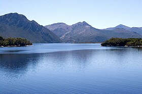
Berbury ( eng. Lake Burbury ) - an artificial lake located in the western part of the island of Tasmania ( Australia ), just east of the city of Queenstown . It was formed as a result of the construction of the Crotty Dam , which blocked the King River.
| Berbury | |
|---|---|
| English Lake burbury | |
 | |
| Morphometry | |
| Height above sea level | 225 m |
| Square | 49 [1] km² |
| Deepest | 75 m |
| Average depth | 30 m |
| Pool | |
| Flowing streams | Eldon , South Eldon , Princess , Gaverner |
| Location | |
| A country |
|
| Region | Tasmania |


The lake area is 49 square kilometers [1] . Thus, it is the sixth largest natural and artificial reservoir of Tasmania, following the lakes Gordon ( 271 km² ), Pedder ( 239 km² ), Great Lake ( 170 km² ), Arthurs ( 64 km² ) and Sorell ( 52 km² ) [ 1] .
The height above sea level is 225 m [2] (according to other data it is 235 m [3] [4] ), the maximum depth is about 75 m , the average depth is about 30 m [3] .
History
In the late 1980s, the Crotty Dam was built on the King River, which was commissioned in 1991 and was originally called King River Dam . As a result, an artificial lake called Berbury ( Lake Burbury ) [5] [6] was formed on the King River.
The lake was named after Stanley Berbery ( Stanley Burbury , 1909–1995) - an Australian lawyer and politician, governor of Tasmania in 1973–1982 (the first governor of Tasmania, born in Australia) [7] .
Geography

Several rivers flow into Lake Berbury - ( Eldon River ), ( South Eldon River ), ( Princess River ), ( Governor River ) and others, and (through the Crotte dam) there is only one river - the King , which then flows west and flows into Macquarie Bay , which connects with the Indian Ocean [8] .
Berberi Lake extends from north to south. In the middle part there is a narrowing over which the highway passes over the Bradshaw Bridge ( The Bradshaw Bridge ) ( Lyell Highway ) connecting Queenstown with Hobart . The length of the lake from north to south is about 23 km , and the width, as a rule, does not exceed 4 km [4] .
Fishing
Lake Berbury is one of the most popular fishing spots in Tasmania. Fishing is allowed throughout the year. In the lake are found kumzha ( Latin Salmo trutta , English brown trout ) and Mikizha ( Latin Oncorhynchus mykiss , English rainbow trout ), whose weight is usually in the range from 0.5 kg to 2 kg , although sometimes they come across and larger specimens [9] [2] . In addition, several species of galaxies are found in the lake - and [9] [2] .
See also
- Tasmania
- King (river)
- Queenstown
- Crotty Dam (eng.)
Notes
- 2 1 2 3 Australian Bureau of Statistics: Tasmania, Lakes . www.abs.gov.au. The appeal date is August 12, 2015.
- ↑ 1 2 3 Lake Burbury Anglers Access Unreferenced (PDF) (not available link) . Tasmania Island Fisheries Service, www.ifs.tas.gov.au. The appeal date is August 17, 2015. Archived January 25, 2013.
- ↑ 1 2 Lake Burbury (English) . www.troutfishtas.com. The appeal date is August 12, 2015.
- ↑ 1 2 Joe Riley. Lake Burbury windlanes (English) . www.tasfish.com. The appeal date is August 17, 2015.
- ↑ Crotty Dam (English) (PDF). www.engineersaustralia.org.au. The appeal date is August 12, 2015.
- Tty Crotty Dam, Tasmania (submission for an Historic Engineering Marker) (English) (PDF). www.engineersaustralia.org.au (2000). The appeal date is August 12, 2015.
- ↑ Lake Burbury (English) . www.discovertasmania.com.au. The appeal date is November 29, 2014.
- Т Topographical map of Tasmania - Lake Burbury . topomapper.com. The appeal date is April 12, 2012. Archived April 19, 2013.
- ↑ 1 2 Fact Sheet for Lake Burbury (HTML) (not available link) . Tasmania Island Fisheries Service, www.ifs.tas.gov.au. The appeal date is August 17, 2015. Archived January 25, 2013.
Links
- Lake Burbury , www.queenstowntasmania.com