Fur ( Dat. Fur , formerly Fuur ) is an island in northern Denmark .
| Fur | |
|---|---|
| Dates Fur | |
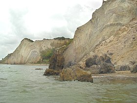 Shores consisting of molera. | |
| Specifications | |
| Square | 22.29 km² |
| Highest point | 76 m |
| Population | 856 people (2010) |
| Population density | 38.4 people / km² |
| Location | |
| Water area | North Sea |
| A country |
|
| Region | Central jutland |
| Commune | Skive |

Geography and geology
Fur Island lies in the Limfjord in northern Jutland . Its area is 22.29 km². The Fur-Sund is 400 meters wide from the mainland, through which the ferry goes. Administratively, the island forms the parish of Fur Sogn , which has been part of the Skive commune of the Central Jutland region since 2007. Fur is a member of the Union of Small Danish Islands .
Wastes dominate the island landscape, only in the north can you see groves planted about 100 years ago. The southern part of the island is a plain gradually rising to the north. The northern shore of Fur is steep, almost sheer. The highest point is Lille Jenshøj , 76 meters above m
There are several villages on Fura - Steener, Nederby, Masbad, Hvirp and Debel. In the areas of Stendalhoye (Stendalhøje) and Smediehoye (Smediehøje) are fields of ancient burial mounds.
Economics
One of the main income items of local residents is the tourism business; more than a thousand guests relax on the island every summer; the pebble beaches of Fura are popular. In addition, they are engaged in agriculture, the extraction of oysters and mussels, as well as the development of deposits of molera in quarries, significant reserves of which were discovered on Fura in the Middle Ages. Numerous paleontological fossils found during mining can be partially seen in the Museum of Fura , located in Nederby.
Literature
- Steen Andersen & Steen Sjørring (Red.): Det nordlige Jylland (erschienen als dritter von fünf Bänden in der Reihe Geologisk set ) - 208 S., zahlr. Abb. und Karten, Geografforlaget, Brenderup (DK) 1997 (2. Auflage der 1. Ausgabe).