Matveev is a small island in the north of Russia, in the Barents Sea . Administratively, it belongs to the Nenets Autonomous District of the Arkhangelsk Region .
| Matveev | |
|---|---|
 View of the island from the lighthouse | |
| Location | |
| A country |
|

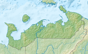
Matveyev Island is located in the southeast of the Barents Sea, which in this place is called the Pechora Sea . The island is small, rocky, the coast is indented with bays. The maximum height above sea level is 11 meters. In the north of the island are two inactive lighthouses. The island is covered with tundra vegetation. The island of Vaigach is located northeast of the island, and the islands of Dolgiy and Golets are to the southeast. The island is part of the Nenets State Nature Reserve .
Since the 14th century, Matveyev Island has been on the route of Pomors from the White Sea to Vaigach and Novaya Zemlya (Novaya Zemlya course). In the sixteenth and seventeenth centuries, Pomeranian Kochi passed by the island, traveling to Mangazeya .
In 1594, before returning to Holland, on the Matveyev Island, the flotilla of Willem Barents reunited, looking for the Northeast route to Asia.
In 1619, the Moscow government, fearing duty-free trade with foreigners, banned the Mangazeysky sea passage. The guards set up in the Yugorsky Shar Strait, on Matveyev Island and the Yamal Peninsula were called upon to monitor the implementation of the decree [1] , as well as "... to visit about German people in order not to go to Siberia, German people could not find German waterways and dry roads in Mangazeya ... "
On June 30, 1924, the Presidium of the All-Russian Central Executive Committee approved the Regulation on the Management of Island Economy of the Arctic Ocean, which provided for the colonization of Matveyev Island [2] . In 1927, by decree of the All-Russian Central Executive Committee, the Council of People's Commissars of the RSFSR, in abrogation of the previous decree, the island was entrusted with the management of the Arkhangelsk provincial executive committee of councils [3] . In 1929, the island was transferred directly to the executive committee of the Northern Territory . On February 10, 1934, Matveyev Island was included in the Nenets National District.
On August 17, 1942, near the Matveyev island, where the Northern Sea Route passes, a German submarine U-209 attacked a caravan of five unarmed vessels sailing from the village of Khabarovo on the Ugra Peninsula in Naryan-Mar . First, the crew of a German submarine opened fire on the P-4 barge, which was towed by the Komsomolets , Nord and Komiles steamboats. On the barge there were Norilskstroy prisoners, women and children. Following them were sunk the Sh-500 lighter and the Komiles towing steamer. The tugboat "Komsomolets" , the radio operator of which began an open broadcast on the attack, caught fire and jumped ashore. The steamer “Nord” managed to move back towards Khabarov. Everyone who didn’t drown was shot by the Germans from an anti-aircraft gun and a machine gun. According to official figures, out of 328 people who were on the ships of the destroyed caravan, 305 people drowned or were shot in the water, only 23 people were saved [4] .
 |  |  |  |  | ||||
| Island lighthouse | Gravestone | Abandoned buildings | Coast | View from the lighthouse |
Notes
- ↑ Historical background on the creation and development of the Yamalo-Nenets customs
- ↑ Administrative and territorial division of the Arkhangelsk province and region in the XVIII — XX centuries.
- ↑ Resolution of the All-Russian Central Executive Committee, SNK of the RSFSR of March 28, 1927 “On the Approval of the Regulation on the Management of the Islands of the Arctic Ocean”
- ↑ Tragedy in the Barents Sea: full version (inaccessible link - history ) .
Links
Maps
- Map sheet R-40-XXIII, XXIV Lyamchina Bay . Scale: 1: 200 000. Terrain condition for 1976. 1982 edition
- Matveyev island on a Wikimapia map
- Matveyev island. Public Cadastral Map (unavailable link) . Archived March 5, 2016.