Degelen is a lowland massif in the territory administratively related to the city of Kurchatov ( Semipalatinsk nuclear test site ) of the East Kazakhstan region [2] . It is located in the eastern part of the Kazakh Upland [3] . The height of several peaks exceeds 1000 meters. The slopes are covered with steppe vegetation. On the river valleys - thickets of bushes.
| Degelen | |
|---|---|
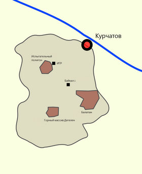 The location of the Degelen Mountains on the territory of the Semipalatinsk test site | |
| Specifications | |
| Length | 20 km |
| Width | 16 km |
| Highest point | |
| Highest point | 1084 [1] m |
| Location | |
| A country |
|
| Region | East Kazakhstan region |
| Mountain system | Kazakh low mountains |

Nuclear testing in galleries
Until 1991, the test site “D” of the Semipalatinsk nuclear test site was located in the Degelen Mountains [4] . In total, from 1961 to 1989, 215 nuclear explosions were carried out in the Degelen Mountains, all in horizontal galleries, traversed in granite massifs [4] [5] . The Semipalatinsk test site was officially closed on August 29, 1991, but in Degelen Mountains the last installed nuclear charge was destroyed only on May 31, 1995 [5] .
Penetration into the boiler cavities of nuclear explosions
In the 1990s, in Degelen Mountains, researchers repeatedly penetrated into the boiler cavities formed after underground nuclear tests [6] . The spherical shape of cavities with a diameter of several tens of meters, a characteristic pillar of rock collapse and a melt lens on the bottom of the cavity are described [6] . An increased temperature of air in the boiler cavity was noted decades after testing. The last trip of a person to a nuclear explosion cavity at the Semipalatinsk test site took place on October 9, 1997 at the adit No. 190, in which a double nuclear test was conducted on April 15, 1984 [6] .C 1996 to 1998, at the Degelen site, work was carried out to close all adits to eliminate the possibility of their reuse for nuclear testing. This work was carried out under the Agreement between the US Department of Defense and the Ministry of Energy and Mineral Resources of the Republic of Kazakhstan on the elimination of nuclear weapons testing infrastructure.
Notes
- ↑ M-44-B Map Sheet .
- ↑ According to Yandex -Map.
- ↑ According to Wikimapia maps.
- ↑ 1 2 Semipalatinsk test site . The appeal date is October 12, 2012. Archived December 13, 2012.
- ↑ 1 2 Destruction of the last nuclear charge in Semipalatinsk. Help . The appeal date is October 12, 2012. Archived December 13, 2012.
- ↑ 1 2 3 Stalkers of the National Nuclear Center of the Republic of Kazakhstan . The appeal date is October 12, 2012. Archived December 13, 2012.