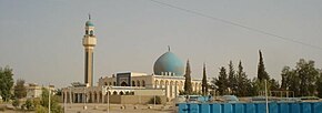
Ana ( Arabic. عانة ) is a small town in the west of Iraq , located in the territory of the Anbar governorate. The administrative center of the same district.
| City | |
| Ana | |
|---|---|
 | |
| A country | |
| Governorate | Anbar |
| History and geography | |
| Center height | |
| Timezone | UTC + 3 |
| Population | |
| Population | |
| Digital identifiers | |
| Postcode | |
Content
Geographical position
The city is located in the northern part of the governorate, on the right bank of the Euphrates , at an altitude of 171 meters above sea level [3] .
Ana is located approximately 157 kilometers north-west of Ramadi , the provincial capital and 238 kilometers west-north-west (WNW) of Baghdad , the country's capital.
Population
According to the latest official census of 1965 , the population was 5,620 [4] . Dynamics of the population of the city by year:
| 1965 | 2012 |
|---|---|
| 5,620 | 4,171 [5] |
History
The city has been known since antiquity. In the Babylonian texts (2200 BCE), the city is referred to as Hanat , in the plates of the period of the rule of the Assyrian king Tukulti-Ninurta II (885 BCE) - as a-na-at , in the texts of the period of the rule Ashshur- Natsir-Apala II - as An-at .
Anato ( Anatho ) is mentioned in the writings of Isidore of Harak :
Then in four shoyuny Anato island on the Euphrates, the size of four stages, it is the city [6] .
- Parthian parking
Notes
- ↑ GEOnet Names Server - 2018.
- ↑ http://www.citypopulation.de/Iraq-Cities.html
- ↑ Physical-geographical data (English)
- ↑ World Gazetteer (English)
- ↑ estimated
- ↑ Isidore Haraksky. Parthian parking