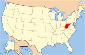
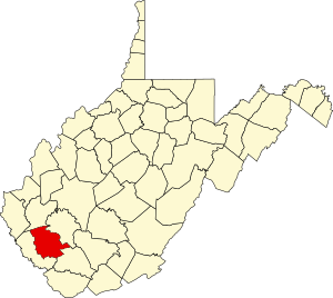
Logan County is one of 55 districts of West Virginia in the United States .
| district | |
| Logan | |
|---|---|
| Logan county | |
| A country | USA |
| Included in | West Virginia |
| Adm. Centre | Logan |
| History and Geography | |
| Date of formation | 1824 year |
| Square | 1181 km² |
| Timezone | Eastern time: VGM -5 / -4 |
| Population | |
| Population | 36 745 people ( 2010 ) |
| Density | 32 people / km² |
| Digital identifiers | |
| FIPS Index | 045 |
| Official site | |
 | |
 | |
Content
Description
The county is located in the southwestern part of the state. Named after the leader of the Iroquois tribe Mingo - Logan . The center of the county is Logan . Open water areas make up 2.6 km² (0.3% of the total area of the district in 1181 km²).
History
The district was created on January 12, 1824 by separating parts of four neighboring districts. In 1895, approximately half of the area was separated from the county, known as Mingo County [1] . In 1921, there was a major clash of local miners with the police and the army, called the Battle of Mount Blair . In 1972, a major flood occurred in the district, as a result of which 125 people were killed, 1,121 were injured, more than 4,000 lost their homes.
Transport
The following major roads pass through the okrug:
- US Route 119 Federal Highway
- West Virginia Route 10
- West Virginia Route 17
- West Virginia Route 44
- West Virginia Route 73
- West Virginia Route 80
Population
According to the 2000 census [2] , 37,710 residents of 14,880 households and 10,936 families live in the okrug. The population density is 32 people per km ². There are 16 807 residential buildings in the district, with a building density of 14 buildings per km ².
Out of the total number of households , 30.50% are children under the age of 18, 57.00% of households are married couples living together, 12.60% of households are single women without a spouse, 26.50% of households households are not related to families , 24.00% of households consist of one person, 11.40% of households consist of elderly people (65 years and older) living alone. The average household size is 2.50 and the average family size is 2.95.
The age composition of the district: 22.10% under the age of 18, 9.30% from 18 to 24, 28.00% from 25 to 44, 26.10% from 45 to 64, and 14.50% from 65 and older. The average age of a resident of the district is 39 years. For every 100 females there are 94.20 males . For every 100 females over 18 years of age, 91.00 are males .
The average household income in the district was 24 603 USD , per family - 29 072 USD . The average earnings of a man were 31 515 USD against 20 212 USD for a woman . The per capita income was 14 102 USD . About 20.80% of families and 24.10% of the total population were below the poverty line , including 34.60% of young people (those who were not yet 18 years old) and 14.40% of those who were over 65 years old.
Historical population dynamics
1830 - 3,680 inhabitants | 1900 - 6955 (-37.3%) | 1970 - 46,269 (-24.9%) |
Racial Composition
- White - 96.3%
- African Americans - 2.6%
- Asians - 0.3%
- Native Americans - 0.1%
- Hawaiians or natives of Oceania - 0.0%
- Two or more races - 0.6%
- Other - 0.1%
- Latinos (of any race) - 0.5%
Attractions
- Chief Logan State Park
- Nature Reserve (partially)
See also
- West Virginia Counties List
- National Register of Historic Places in Logan County
Notes
- ↑ History of Mingo County Archived November 13, 2007. on the site polsci.wvu.edu
- ↑ Data from the US Census Bureau for Logan County (West Virginia ) . Date of treatment November 16, 2009. Archived April 11, 2012.
- ↑ Logan County Archived on July 14, 2011. on quickfacts.census.gov
Links
- Official site
- Logan County History at polsci.wvu.edu
- Logan County at epodunk.com
- Logan County: population, unemployment, prices, crime, healthcare, mortality, etc., on city-data.com
- Archive and Bibliographic Information for Logan County, West Virginia