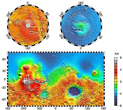
The Great Northern Plain (Vastitas Borealis [1] ) is the largest lowland on the planet Mars . It is located in the northern latitudes of the planet and surrounds the northern polar region. Sometimes it is simply called the Northern Plain or Northern Lowland of Mars. The plain lies 4-5 km below the average radius of the planet. In the north lies Planum Boreum [2] (North Plateau [3] ).
The name of the region was given by Eugene Michelle Antoniadi , who noted various indications of the albedo of the northern plains in his book fr. La Planète Mars (1930) . The name was officially adopted by the International Astronomical Union (IAU) in 1973 [4] .
Two basins are recognized in the Great Northern Plain: the Northern Polar Basin and the Utopia Plain . Some scholars have suggested that once in the history of Mars, plains were covered by the ocean , and the alleged coastline was drawn along their southern borders. Today these are slightly sloping plains marked by ridges, low hills and rare craters. The Great Northern Plain is noticeably smoother than a similar topographic region in the south of the planet.
In 2005, the Mars Express satellite of the European Space Agency discovered a significant amount of water ice in the crater (coordinates 70.5 ° N and 103 ° E) of the Great Northern Plain. The diameter of the crater is 35 kilometers; its bottom is about two kilometers below the rampart. The nature of the terrain is suitable for the formation of stable ice deposits. It was found that, despite the summer evaporation of carbon dioxide in the Northern Hemisphere, water ice can be considered stable throughout the year [5] .
On May 25, 2008 (at the beginning of the Martian summer), the Phoenix probe ( NASA ) landed in the area of the Great Northern Plain, unofficially referred to as the “ Green Valley ” ( Eng. Green Valley ). The coordinates of the landing site [6] . This stationary device collected and examined soil samples for water, as well as to determine whether there were ever conditions on the planet suitable for the development of life. Phoenix completed the program planned for 90 Martian days and conducted scientific research of 157 Martian days until October 29. Then, the lack of energy caused by weak sunlight in the winter conditions of Mars caused the communication to cease, the last signals were received on November 2, 2008 [7] .
Content
Surface
Unlike several places visited by Viking and Pathfinder , all the stones under the station and near the landing site are small. As far as the camera can see, the surface is flat, but “divided” by polygons. The diameter of the figures is 2-3 meters, and they are delimited by gutters from 20 to 50 cm deep. These formations are caused by the reaction of ice in the soil to significant changes in temperature [8] . The upper part of the soil is covered with a crust. A microscopic examination showed that the soil consists of flat (probably clay) and rounded particles. When scooping up the soil, they stuck together. In contrast to the dunes and ripples observed by other devices in other parts of Mars, neither ripples nor dunes are visible in the area of the Phoenix landing. The ice is located a few centimeters below the surface in the center of the polygons. Along the edge of the figured formations of ice soil is at least 20.48 cm. In summer, under the influence of the atmosphere of Mars, ice slowly disappears [9] . In winter, evaporation settles in the form of accumulations of snow on the surface [10] .
Surface
According to the results of studies published [11] on the results of the completion of the Phoenix mission in the journal Science , chloride , bicarbonate , magnesium , sodium , potassium , calcium, and possibly sulfate were found in the samples. The acid / alkaline balance (pH) is defined as 7.7 +/- 0.5. The strongest oxidizing agent perchlorate (ClO 4 ) has also been discovered. The presence of perchlorate was a very important discovery, since this chemical compound has the potential to be used as a reagent for rocket fuel, and also as an oxygen source for future colonists. Under certain conditions, perchlorate can inhibit the existence of life, but some microorganisms receive energy from this substance (anaerobic recovery).
Soil Structure
Most of the surface of the Great Northern Plain is covered with patterned soil. Sometimes the surface has the shape of polygons. Close-ups of the polygon-shaped soil structure were provided by the Phoenix spacecraft. In other places, the surface is represented by chains of low natural embankments. Some scientists called the presented formations “fingerprints”, since many lines look like someone’s fingerprint. A similar relief of both forms can be found in the subglacial regions of the Earth , such as Antarctica . Antarctic polygons are formed by repeated expansions and contractions of the mixture and soil and ice occurring during seasonal temperature changes. When dry sand falls into faults, the resulting sand wedges enhance the seasonal effect. As a result of this process, a network of polygons of “tense” texture is formed [12] .
Dunes isp. Olympia Planitia Dunes visible HiRISE .
Gypsum was discovered by MRS here [13] .Patterns on the ground called “fingerprints”.
Dark dots are low natural mounds.
In the center: a ring of dark volcanoes located along the edge of the impact crater. Image from Mars Global Surveyor .
See also
- Planetary nomenclature
Notes
- ↑ Burba G.A. The nomenclature of the relief of Mars. - M .: Nauka, 1981. - 85 p. - 1000 copies, p. 58: "List 1, Great Plain. Russian name Great Northern Plain, Latin name Vastitas Borealis"
- ↑ Planum Boreum // USGS
- ↑ Burba G.A. The nomenclature of the relief of Mars. - M .: Nauka, 1981. - 85 p. - 1000 copies, p. 62, p. 71: "Figure 13. The Northern Polar Region"
- ↑ Vastitas Borealis , USGS Planetary Nomenclature
- ↑ Water ice in crater at Martian north pole . European Space Agency . Date of treatment August 4, 2007. Archived October 2, 2012.
- ↑ Lakdawalla, Emily Phoenix Sol 2 press conference, in a nutshell . The Planetary Society weblog . Planetary Society (May 27, 2008). Date of treatment June 4, 2008. Archived October 2, 2012.
- ↑ Mars lander aims for touchdown in 'Green Valley' . New Scientist Space. Date of treatment April 14, 2008. Archived October 2, 2012.
- ↑ Levy, J, J. Head, and D. Marchant. 2009. Thermal contraction crack polygons on Mars: Classification, distribution, and climate implications from HiRISE observations. Journal of Geographical Research: 114. p E01007
- ↑ The Dirt on Mars Lander Soil Findings. Andrea Thompson, 02 July 2009 (Space.com)
- ↑ Whiteway, J. et al. 2009. Mars Water-Ice Clouds and Precipitation. Science: 325. p 68-70
- ↑ Hecht MH, Kounaves SP, Quinn RC, West SJ, Young SM, Ming DW, Catling DC, Clark BC, Boynton WV, Hoffman J, Deflores LP, Gospodinova K, Kapit J, Smith PH. Detection of perchlorate and the soluble chemistry of martian soil at the Phoenix lander site: [ eng. ] // Science. - 2009.- T. 325, no. 5936 (3 July). - S. 64-67. - DOI : 10.1126 / science.1172466 .
- ↑ Signs of Aeolian and Periglacial Activity at Vastitas Borealis (HiRISE Image ID: PSP_001481_2410)
- ↑ Murchie, S. et al. 2009. A synthesis of Martian aqueous mineralogy after 1 Mars year of observations from the Mars Reconnaissance Orbiter. Journal of Geophysical Research: 114.