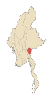
Kaya [1] (Kaya; also called Karenni ) is a state ( national district ) in Myanmar in the southeast of the country. It borders with Thailand and the states (national districts) of Shan and Karen . Between 18 ° 30 'and 19 ° 55' N and between 94 ° 40 'and 97 ° 93' in. The administrative center is the city of Loiko . Population 349,875 The population density is 29.82 people / km². The population of predominantly Kaya is a nationality, which is also called red Karen or Karenni, belong to the group of Karen Sino-Tibetan language family.
| ကယား Kai State ( MLCTS : ka.ya: pranynai) | |
 | |
| Capital | Loiko |
| Region | Southeastern |
| Area | 11 733 km² |
| Population | 349,875 (2012) |
| Peoples | kaya , karen , padaung , burmese , shans , pa-o |
| Religion | Buddhism , Christianity , animism |
 | |
Content
- 1 History
- 2 Demographics
- 3 Administrative divisions
- 4 Economics
- 5 See also
- 6 notes
- 7 References
History
Until 1948, there were three Karen principalities in the state:
- Bolakh (Bawlake) - 1471.1 km², 13 802 people. (1931)
- Kantarawaddy - 8,187 km², 30,677 people (1931)
- Chebogyi (Kyebogyi) - 2046.1 km², 14,282 people. (1931)
In August 1948, leader Karenni U Be Thu was assassinated by central government police for his disagreement with joining the Union of Burma. The troops that still stand there were introduced into the state.
On October 5, 1951, the state of Karenni was renamed Kaya. In 1952, the former Shan principality of Mongpe (Mong Pai) was included in its composition.
In 1957, proponents of independence formed the Karenni National Progressive Party (KNPP), which was supported by the newly created Karenni Army (KA). This army continues to resist to this day, except with the exception of the short ceasefire in 1995 . Against it are the Kaya New Land Party (KNLP) and Karenni National Liberation Front (KNPLF) parties, which have now allied with the central government of Burma.
In 1976, the SLORC ruling military junta in Burma took action to forcibly relocate Karenni villages to strip the opposing army of support, in violation of civil rights. At the same time, the resettled persons did not receive adequate compensation and ended up in places deprived of normal water supply and the usual infrastructure, including medical care. An estimated 50,000 carnies have been resettled. Thousands of people fled to Thailand .
Although ceasefire negotiations are regularly resumed, no final agreement was found for 2005, and armed clashes continually reoccur.
Demographics
In the state of Kaya there are ten ethnic groups traditionally living in this territory. The following peoples are distinguished by language:
- Kaya (red Karen)
- Padaung (Kayan) - famous “female giraffes” who crank their neck with iron rings
- Bwe
- Heba (white Karen)
- Manu (Manumano)
- Yintale (Yantale)
- Zayne ( Latha )
- lahti )
- Geko
- Yingbo
- Paku
Administrative Division
The state's administrative center is the city of Loikaw. The state consists of two districts (Bolakha and Loiko), which are divided into seven districts, which include 106 towns and villages.
State Districts [2] :
- Bolakha (Bawlakhe)
- Demoso (Demoso)
- Hpasawng
- Hpruso (Hpruso)
- Loikaw
- Mese
- Shadaw
Economics
In the state of Kaya, rice is the main culture; irrigation is developed. In addition, corn, sesame, garlic, peanuts and vegetables are grown. Minerals are mined - alabaster , tin and tungsten . Valuable species of wood are teak and pine . Illegal logging has led to a sharp decrease in forest area. A hydroelectric power station has been built at Lopita Falls, which produces 20% of Burma’s electricity, and therefore has high strategic importance. The hydroelectric power station was built by the Japanese after a period of Japanese occupation in the form of reparation.
Theoretically, the state could become a good center of tourism due to the beautiful nature, mountains and interesting local customs. However, the political situation does not allow tourism to expand widely. In addition, there are difficulties in transport and communications. Currently, foreigners require a permit to visit the county, which is not always issued by the military. Typically, this permission covers a neighborhood of 25 km from the capital Loiko. In fact, the government keeps under its firm control only the state capital and part of the western territories.
See also
- Burma Civil War
Notes
- ↑ F. L. Ageenko, Dictionary of Russian Names. 2010
- ↑ Myanmar States / Divisions and Townships , Myanmar Information Management Unit (December 2007).
Links
- Conflict and Displacement in Karenni: The Need for Considered Responses . Burma Ethnic Research Group . Date of treatment May 22, 2006. Archived February 19, 2012.
- Karenni State at Unrepresented Nations and Peoples Organization (UNPO)
- Karenni Independence Through Education Organization