The main Caucasian (Dividing Range) ridge is a continuous mountain range that extends more than 1100 km from the northwest to the southeast from the Black Sea ( Anapa region) to the Caspian Sea (Mount Ilkhydag to the northwest of Baku ). The Caucasian ridge divides the Caucasus into two parts: Ciscaucasia ( North Caucasus ) and Transcaucasia ( South Caucasus ).
| The main Caucasian ridge | |
|---|---|
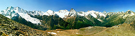 The main Caucasian ridge in the region of Dombay | |
| Highest point | |
| Highest peak | Bezengi wall |
| Absolute height | 5068 [1] m |
| Location | |
| Country |
|


The main Caucasian ridge separates the basins of the Kuban , Terek , Sulak and Samur rivers in the north and Inguri , Rioni and Kura in the south.
The mountain system , which includes the Main Caucasus Range (or the Greater Caucasus Range ), is called the Greater Caucasus , in contrast to the Lesser Caucasus - a vast highland located south of the Rioni and Kura valleys and connected directly with the hills of Western Asia.
Content
Regions
The division of the Caucasus into [4] is accepted:
- Western Caucasus (limited from the east by Elbrus);
- Central Caucasus;
- East Caucasus (limited from the west by Kazbek).
General Information
The entire system of the Main Caucasus Range occupies approximately 260,000 km². The northern slope is about 145,000 km², and the southern is about 115,000 km².
The width of the Caucasus ridge [5] in the western (somewhat west of Elbrus , and including the Elbrus massif) and eastern ( Dagestan ) parts is about 160 ... 180 km, in the central - about 100 km; both ends are very narrow and represent (especially the western) insignificant width.
The highest heights in the center, where the highest and most rocky section of the ridge is located, are the Bezengi wall with the peaks of Shkhara (5068 m), Dzhangitau (5058 m), and others. The forward elevations accompanying the Main Range, in most cases, do not have the character of continuous chains, but short ridges or mountain groups associated with the spurs ridge and broken in many places by deep river gorges, which, starting in the Main Range and breaking through the forward elevations, descend to the foothills and overlook the plains. Thus, almost over the entire length (in the west — from the south, in the east — from the north), a number of high basins adjoin the watershed ridge, in most cases of lake origin, closed on one side by the heights of the watershed, as well as its spurs, and on the other - in separate groups and short ridges of advanced hills, which in some places are superior in height to the main chain.
Transverse depressions prevail on the north side of the watershed, and longitudinal on the south, except for its western end. It is also characteristic of the Caucasus ridge that many of the primary peaks do not lie on the Dividing Ridge, but on the ends of its short spurs heading north (this is the position of the peaks; Elbrus 5642 m, Dykhtau 5204 m, Koshtantau 5152 m, Gulchi-Tau 4447 m , Sugan-Tau 4487 m, Adai-Khokh 4405 m, etc.). This is the so-called Lateral Caucasian ridge , which stretches from the north side of the main one, in some places it is interrupted. These are sections where between the Main Caucasian ridge (GKH) and the Rocky ridge there is no Lateral, that is, the Main Caucasian ridge immediately adjacent to the Rocky ridge; such a site, for example, is the interfluve of Urukh and Ardon , where the spurs of the Main Caucasian ridge immediately adjoin the Rocky Range.
The northern, more developed slope of the Caucasian ridge, formed by many spurs adjoining generally almost perpendicular to the Main ridge and separated by deep transverse valleys, reaches a very significant development in the vicinity of Elbrus ( Elbrus ledge ). The most significant uplift [ Elbrus-Mineralovodsk fault zone ] goes straight from this peak to the north, serves as a watershed between the waters of the Kuban (Azov) and Terek (Caspian Sea) and, lowering by ledges further, spreads into the island mountains of Pyatigory and the vast Stavropol Upland (main uplift reaches the frontal ledges Pasture Range , bordering the horseshoe Kislovodsk depression, turns south (Kislovodsk) east, along with gorges and river valleys stretches to the Tersko-Sunzhen interfluve, forming Tersko-Sunzhensky Upland , and further up to the Andean Range ).
The northern slope is even more developed in the eastern part of the Caucasian ridge, where numerous, and very significant in height and length, its spurs form the vast mountain country of Dagestan ( Dagestan ledge ) - a large mountain region, closed by the high Andean , Sala-Tau and Gimrinsky (2334 m ) ridges. Gradually lowering to the north, the northern slope is formed by many advanced hills, which in places are in the form of ridges and mountain spurs; Such mountain ranges include the so-called Black Mountains (see) { Pasture Range }, located north of the Main Range, at a distance of [18 (?) -] 65 [ specify ] km from it. Black mountains form gentle and long slopes, in most places covered by dense forests (hence the name [6] ), and fall to the south by steep cliffs. The rivers flowing from the Main Range, break through the Black Mountains through deep and narrow, very picturesque gorges (Sulak canyon with a depth of up to 1800 m); the height of this forward chain is generally insignificant (to the west of the Dagestan ledge [7] ).
The southern slope is especially poorly developed in the western and eastern parts of the ridge, reaching rather significant orographic development in the middle, where parallel elevations adjoin it, forming longitudinal valleys of the upper reaches of the Rioni , Inguri and Tskhenis Tskhali , and long spurs separating the Alazani basins go south , Iori and Chickens .
The steepest and least developed section of the southern slope is where it falls to the Alazani Valley; Zagatala , located at an altitude of 355 m near the southern bottom of the Caucasus Range, is located in a straight line only 20 km from its ridge, reaching here an altitude of more than 3,300 m above sea level. The Caucasian ridge is not easy to reach; only at its western and eastern extremities are there comfortable and low passes, which are quite accessible all year round for communication.
Throughout the rest of the route, with the exception of the Mamison and Cross passes (see the Georgian Military Highway ), paths through the ridge in most cases represent pack or even pedestrian paths, partly completely inaccessible for use in the winter season. Of all the passes, Cross (2,379 m), through which the Georgian Military Highway passes, is of the greatest importance.
Glaciers
By the number of glaciers, their area and size, the Caucasus Range is almost not inferior to the Alps . The largest number of significant glaciers is in the Elbrus and Terek parts of the ridge, with glaciers of the first category in the basins of the Kuban, Terek, Liakhva, Rioni and Inguri, about 183, and the second category - 679. In total in the Greater Caucasus , according to the “Catalog of Glaciers of the USSR” (1967 —1978), 2,050 glaciers with a total area of 1,424 km² [4] . The size of the Caucasian glaciers is very diverse, and some of them (for example, Bezengi ) are almost inferior in size to the Alechsky glacier in the Alps. The Caucasian glaciers never go down as low as, for example, the Alps, and in this regard are very diverse; thus, the Karaugom glacier ends down to an altitude of 1,830 m above sea level [4] , and the Shah-dag glacier (Shah-Dag (4243 m), in the Bazar-Dyuzyu region) - to an altitude of 3,320 m above sea level. The most famous glaciers of the Caucasus Range are [4] :
| Glacier name | The mountain that descends | The height of the lower end of the glacier, in m above sea level | Glacier length in km Total | Glacier area in km² |
|---|---|---|---|---|
| Bezengi (bass. Cherek of Bezengi) | Bezengi wall : Gestola , Shkhara , Dzhangitau , Katyntau | 2,080 m | 17.6 | 36.2 km² |
| Dykh-Su ( Dykh-Kotyu-Bugoysu ) (bass. Cherek Balkarsky) | Shkhara , Aylam , Bashauzbashi | 2,070 m | 15.3 km | 34.0 km² |
| Karaugom (Urukh, bass. Terek) | Karaugom (and / or Burjula) [8] , Wilpat, Skatikom (Skatikomokhokh) | 1 830 m | 13.3 km | 26.6 km² |
| Tsaneri [Zanner] (bass. Inguri) | Tetnuld | 2 390 m | 12 km | 28.8 km² |
| Devdoraki (bass. Amali) | Kazbek | 2,260 m | 7.3 km | 7.0 km² |
| Big Azau (Baksan, bass. Terek) | Elbrus, southern shoulder | 2,500 m | 10.1 km | 19.6 km² |
| Snow Valley Jikyugankez [frozen lake, Jikauchenkez] ( Malka and Baksan) | Elbrus, east shoulder | |||
| Tsey (Ardon, bass. Terek) | Wilpat, Changchah, Mamison | |||
| Lehzir [Lekzir, Lekziri] (bass. Inguri) | Ullukara , Lazga , Dzhantugan , Bashiltau | 13.6 km | ||
| Yazengi (Yusengi) (r. Yusengi, bass. Baksan) | Donguzorun-Cheget-Karabashi (app.), Yusengi ridge (east) | |||
| Skheldy glacier (Adylsu, bass. Baksan ) | Skhelda (4368 m), Chatyntau (4411 m) |
In the ice age, the glaciers of the Caucasus Range were much more numerous and vast than today. Currently, most of the glaciers of the Caucasus Range are in a retreat period that has lasted for several decades.
See also
- Caucasus mountains
Notes
- ↑ The main, or Dividing, ridge. Great Russian Encyclopedia
- ↑ This geographical feature is located in Abkhazia , which is a disputed territory . According to the administrative division of Georgia , the disputed territory is occupied by the Abkhaz Autonomous Republic . In fact, the disputed territory is occupied by the partially recognized state of the Republic of Abkhazia .
- ↑ This geographical feature is located in South Ossetia. According to the Georgian constitution , the territory of South Ossetia is included in Georgia. In fact, South Ossetia is a partially recognized state , the territory of which is not controlled by the Georgian government.
- ↑ 1 2 3 4 Dolgushin L.D., Osipova G.B. Glaciers. - M .: Thought, 1989 . - 447 p. - ISBN 5-244-00315-1 .
- ↑ The width of the mountain ranges (in total) of the Greater Caucasus, and not just the Greater Caucasus Mountain Range.
Based on the above, the area of the axial Dividing Ridge is 2 600 km², and the length is 1100-1150 (directly on the map) - 1500 km (along the ridge). That is, the width of the Main Caucasian ridge [mountain ridge - the line of intersection of the slopes, the top of the ridge along which the watershed line] in the estimated area is on average 2 (1.75-2.25) km. - ↑ Blackwood, black forest, black forest, deciduous forest : birch, linden, alder, elm (birch), aspen, oak, ash, sedge, etc. (as well as (?) Caucasian persimmon - ebony); in which black game, wild boar, wild boar, black-breasted bird (Kara-Kuyruk), and black mushrooms, wolves, owls, russula and bovines are found (which were during the conquest of the Caucasus) ...
- ↑ We are no longer talking about the Black Mountains , located to the north in the lower reaches and the middle reaches of the rivers - at altitudes that generally do not exceed 1,200-1,500 m.
- ↑ Map sheet K-38-40 Top Zgid . Scale: 1: 100,000. Status of the terrain for 1984. 1988 edition
Karaug
Burjula
Links
- Massalsky V.I. Caucasus Range // Encyclopedic Dictionary of Brockhaus and Efron : 86 volumes (82 volumes and 4 additional). - SPb. , 1890-1907.