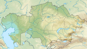
Markakol ( Kazakh. Marqakól ) is a lake in East Kazakhstan .
| Lake | |
| Marcacol | |
|---|---|
| kaz. Markakul | |
 | |
| Morphometry | |
| Absolute height | 1447 m |
| Dimensions | 38 × 19 km |
| Square | 455 km² |
| Coastline | about 100 km |
| Deepest | 27 m |
| Average depth | 14 m |
| Pool | |
| Flowing river | Kalzhir |
| Location | |
| A country |
|
| Region | East Kazakhstan region |

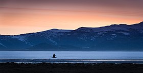
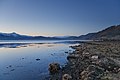
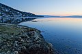
The water in Markakol is very clear, and its picturesque shores are indented by bays . In places, they are overgrown with forest or cliffs , and in some places covered with meadows .
The Markakol basin is bordered by the Kurchumsky and Azutau mountain ranges. In the northeast, it articulates with the Bobrovskaya Depression, and in the southwest along the Kalzhyr River, it has access to the Zaisan Valley. The lake is located at an altitude of 1447 m above sea level, has an oval-elongated shape and extends from the north-east to the south-west. The length of the lake is 38 km, the width is 19 km, the area is 455 km², the coastline is 106 km, the average depth is 14.3 m, and the maximum depths are 24-27 m. The lake bowl contains 6.5 km³ of water. The catchment area is 1180 km². In total, 50 watercourses flow into the lake, the main ones are Topolevka, Tikhushka, Elovka, Karabulak, Zhirenka. From the lake flows the only river Kalzhyr .
The color scheme of Lake Markakol is diverse: from blue or blue in clear weather, to gray-black, silver when the weather changes. The state of the water mirror during the day changes many times. The water in the lake is ultra-fresh, very soft, slightly acidic, belonging to the hydrocarbonate class, calcium group. The lake freezes for the winter. The beginning of freezing is marked from the second decade of October, the average date is November 20. In winter, the source of the Kalzhyr river remains unfrozen, and in warm winters the beds of some mountain rivers flowing into Lake Markakol. The thickness of the ice reaches 60-120 cm.
The beauty of the lake was admired by the well-known geographic travelers P. P. Semenov-Tian-Shansky , K. V. Struve [1] ( German: Karl von Struve ), G. N. Potanin [2] , V. V. Sapozhnikov .
The origin of Lake Markakol is associated with one of the glacial phases of the Quaternary Alpine tectonic cycle, when, as a result of uplifts and faults, a peculiar system of modern ridges and intermontane depressions was formed, which were then exposed to glaciation, the traces of which are well expressed on the watershed parts of the Kurchum ridge .
The area is composed of metamorphosed rocks , broken through by the thick vein bodies of the main basaltoid rocks and small masses of alkaline granites . Closer to the mountains, tall larch trees grow on their slopes. The lake is rich in fish: uskuch ( lenok ), grayling . There are many birds here. In coastal meadows, loons , grebes , ducks , gulls and waders nest. Grouse , black grouse , capercaillie and partridge are found in the forests around the lake.
The climate in this part of the country is typically continental. Winter is harsh, snowy, the temperature reaches up to −55 degrees Celsius. The average annual temperature is −4.1 degrees Celsius (the lowest in the Southern Altai ). In summer, the air temperature rises to 29 degrees Celsius. The average daily temperature above 0 degrees lasts 162 days, below 0 degrees - 203 days.
Lake Marcacol
Lake Marcacol

Urunhayk village on the eastern shore of the lake

Map of Markakolsky reserve and its environs


Notes
- ↑ Karl Wilhelmovich Struve
- ↑ G. N. Potanin's Travels to East Kazakhstan (Unavailable link) Date of treatment March 26, 2013. Archived on September 21, 2013.