NAVTEX ( Eng. NAVTEX - “NAVigational TEleX” ) is an international automated warning system. In navigational navigation it is used to receive navigation and meteorological safety information ( Maritime Safety Information ) and serves as a component of the Global Maritime Distress and Safety Communication System ( GMDSS ) of the International Maritime Organization in accordance with SOLAS-74/88 . The information is distributed in text mode ( narrow-band letterpress mode , UBHR) in the microwave band at a frequency of 518 kHz (in English), in other countries (except the USA), in addition to this frequency, a frequency of 490 kHz can be used to transmit messages in national languages (including in Russian). In the area of the Suez Canal, due to difficult weather conditions (the proximity of the deserts of Egypt and the Arabian Peninsula, which form dust screens that are difficult to overcome at a frequency of 518 kHz), a backup frequency of 4209.5 kHz is used.
Content
- 1 Stations and warning areas (NAVAREA)
- 2 Sort stations
- 3 Types of Messages
- 4 Message structure
- 5 weather forecast
- 6 Technique
- 7 Terminals
- 8 References
Warning Stations and Areas (NAVAREA)
The surface of the globe is divided into 21 areas NAVAREA (from the English - Navigational Area ). Each station in the warning area is assigned a letter of the Latin alphabet from A to Z (in the northern hemisphere from north to south). Broadcasting stations in one warning area is carried out sequentially, according to the schedule. The broadcasting range of the station is 200-600 nautical miles . In total there are 153 operating stations. Of these, 10 are located in Russia, two stations operate in Ukraine (Black Sea - Odessa, Sea of Azov - Berdyansk) and one in Estonia ( Tallinn )
Sort stations
Sorting stations is carried out both automatically and manually.
Types of Messages
| A | Navigation warning |
| B | Meteorological warning |
| C | Ice report |
| D | Rescue message, case of piracy |
| E | Weather forecast |
| F | Information for Pilots |
| G | Decca system message |
| H | LORAN system message |
| I | message system omega |
| J | Status of GPS and GLONASS satellites |
| K | Supplement to "J" |
| L | Drilling Platform Loss Report |
| V | Detailed navigation warning announced via A |
| Wxy | Test mode |
| Z | No warning |
Message Structure
The message structure may differ from the example below, except for the start and end codes. The final code may also contain the NNN group, which means that the received message contains too many errors (more than 4%) and will be received again the next time.
| Message | Explanations |
|---|---|
ZCZC LE05 031452 UTC MAR ROGERLAMD RADIO WEATHER-FORECAST MELDUNG .... Nnnn | Start Code (ZCZC), Station (L), Message Type (E), Sequence Number (05) |
Weather Forecast
| Message | Explanations |
|---|---|
ZCZC JE92 Error Rate = 0.0% 170500 UTC MAY SWEDISH WEATHER SHIPPING WEATHER SUMMAR FROM HIGH IN GREENLAND RIDGE OF HIGH SOUTHEASTWARDS TO SWEDEN, WEAK AREA OF LOW OVER WEST_EUROPE: LOW GALEWARNINGS NIL FORECAST VALID 24 HOURS SKAGERAK; KATTEGAT; THE SOUND: AROUND EAST 3-7 M / S SOMEWHAT INCREASING; IN WESTERN PART OF SKAGERAK DURING DAY AROUND 10. MAINLY GOOD VIS, IN SKAGERAK AT TIMES SOME RAIN. THE BELTS; WESTERN BALTIC: Belt, EASTERLY 7-11. GOOD VIS. Nnnn | Start code, Station index, message type and error rate |
Technique
NAVTEX messages are transmitted by ground stations in FEC mode ( Telex - English Forward Error Correction ).
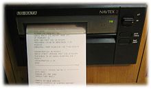
Terminals
The receiving station consists of an active antenna and a receiver with an information output device. Typically, receivers with a display and an integrated printing device using thermal paper are used. Recently, cheaper terminals with a liquid crystal display, equipped with an RS-232 connector, or antennas connected via USB to a personal computer with the appropriate software, have spread.
Using a domestic radio and the NAVTEX Decoder 1 program, it is possible to receive NAVTEX messages without the above terminals.
Links
- free NAVTEX decoder (with a database and sample messages )
- Global Maritime Communications System
- http://de.wikipedia.org/wiki/Navtex-Stationen List of NAVTEX stations (German)
- fldigi - Digital modem program for Linux, Free-BSD, OS X, Windows XP, NT, W2K, Vista and Win7 (can decode NAVTEX)