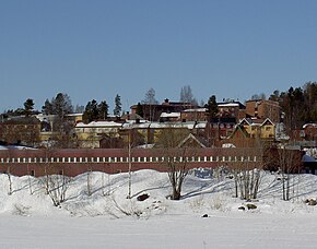
Everturneo [3] or Evertorneo [4] ( Swedish Övertorneå , Fin. Matarenki ) is a settlement in the north-east of Sweden . The administrative center of the commune is Everturneo Lena Norrbotten . It is located on the Tourneelven River, which runs along the border with Finland, about 110 km northeast of Lulea . On the other side of the river is the city of Ylitornio .
| City | |
| Everturno | |
|---|---|
| Swede. Övertorneå | |
 | |
| A country | |
| Linen | Norrbotten |
| Commune | Everturneo |
| History and Geography | |
| Area | |
| Center height | |
| Timezone | and |
| Population | |
| Population | 1917 [1] people ( 2010 ) |
The population according to 2010 is 1917; according to the data for 2000, it numbered 2006 people. The area around the city is hilly. South of Everturno is the Isovaara Nature Reserve.
Population
| Year | Population |
|---|---|
| 1970 | 1674 |
| 1975 | 1700 |
| 1980 | 2039 |
| 1990 | 2132 |
| 1995 | 2179 |
| 2000 | 2006 |
| 2005 | 1965 |
| 2010 | 1917 |
Source: [5]
Twin Cities
- Cola [6]
Notes
- ↑ Tätorternas landareal, folkmängd och invånare per km 2 2005 och 2010 (Swedish) . Statistics Sweden (December 14, 2011). Date of treatment January 10, 2012. Archived January 10, 2012.
- ↑ Statistikdatabasen : Landareal per tätort, folkmängd och invånare per kvadratkilometer. Vart femte år 1960–2015 - Central Statistical Bureau of Sweden .
- ↑ Everturneo // Dictionary of geographical names of foreign countries / ed. ed. A.M. Komkov . - 3rd ed., Revised. and add. - M .: Nedra , 1986.- S. 440.
- ↑ Topographic maps of the General Staff
- ↑ Statistiska centralbyrån - Folkmängd i tätorter 1960-2005 unopened (unavailable link) . Date of treatment June 23, 2011. Archived on September 21, 2013.
- ↑ Twin cities of the Murmansk region // Kola Encyclopedia . In 5 t. T. 1. A - D / Ch. ed. A.A. Kiselev . - SPb. : IP; Apatity: KSC RAS, 2008 .-- S. 502.