Abu Musa [2] [3] ( Persian بوموسی ) - an island in the eastern Persian Gulf , has the shape of a trapezoid, one of the six islands of the archipelago in the Strait of Hormuz . Area - 12 km² [4] .
| Abu musa | |
|---|---|
| Persian. بوموسی | |
 | |
| Specifications | |
| Square | 12 km² |
| Highest point | 110 m |
| Population | 1953 people (2012) |
| Population density | 162.75 people / km² |
| Location | |
| Water area | Persian Gulf |
| A country |
|

According to the administrative division of Iran , it is part of the province of Hormozgan . The ownership of the island is disputed by the United Arab Emirates , which consider it as part of the Emirate of Sharjah . Iran considers the island to be part of its state since ancient times [5] [6] [7] [8] [9] .
As of 2012, the population of the island is 1953 people [10] .
The island has the same city and the airport, which is the largest [ where? ] , with a population of 1868 people.
Title
The inhabitants of the island call it “Gap-sabzu”, which means “Big Green Lawn” in Persian. On old maps, the island is indicated as:
- “Boum-Ouw” ( pers. بوماوو - “Boum-Ov” ) or “Boum-Ouf” ( pers. بوماوف ), which means “Wet soil”.
- “Boum-Souz” ( pers. بومسوز - “ Bowmouse ” ), “Boum-Sou” / “Boum-Souw” ( pers. بومسو - “Bowm-Souz” / “Bowmouse” ) or “Gap -Sabzou ”( Persian گپسبزو - “ Gap-Sapzou ” ), which means“ Green Country ”in Persian. [eleven]
Also, the island is called "Bum Musa" ("Boom Musa") , which in Persian means "Land of Moses." [eleven]
Geography
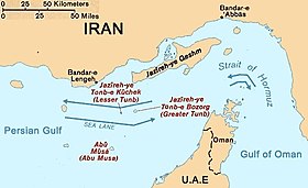
The island is located 75 kilometers from the port of Bender Lenge (adm. Center of the shakhrestan Bender Lenge ) and 123.3 km. from the Strait of Hormuz (metro Ras-sheikh-Mosad ( Oman )). Abu Musa is the farthest island from the Iranian Persian Gulf coast. It is located 46 meters above sea level. The highest point is Mount Halva (110 m) [12] .
It stretches from north to south for 4.85 km. [13]
The length from west to east is 4.53 km. [14]
The greatest length is 5.37 km. (from s-s to s-s). [15]
The nearest land: about. Small Tomb (Iran), located at a distance of 38.7 km. north of the island. [sixteen]
Nearest island in the west: about. Sirri (Iran), which has the nearest settlement, is located at 45.3 km. west of the island. [17]
The nearest mainland: Eurasia (part of the world: Asia (Arabian Peninsula)), the UAE coast ( Umm al-Qaiwain (nearest city)) is located at a distance of 58.8 km. southeast of the island. [18]
The nearest mainland territory of Iran: the coast of the province of Hormozgan (Iran), is located at a distance of 70.7 km. to North. [nineteen]
Located at 100km. from the Musandam Peninsula ( Ghalilah (UAE)). [20]
Distance to Bandar Abbas , the administrative center of the province of Hormozgan: 178.7 km. [21]
Distance to Tehran , the capital of Iran: 1130km. [22]
Climate
Warm and humid. The main occupation of local residents is fishing.
Power
The management of the territory of the island of Iran is disputed by the UAE. [23] [24] [25] The dispute over the ownership of Abu Musa has been ongoing since 1974. The island has been under Iranian control since the beginning of the 20th century . [26] In 1906, an iron oxide deposit on the island was ceded to the German company Vinkhaus. In 1907, the island was returned to Iran at the insistence of the British Empire, resulting in an international incident. [27] It has been under British control since 1908.
In 1960, she transferred control of the island to the emirate of Sharjah (now part of the UAE), occupied by her. In 1968, she announced the return of Abu Musa to Iran. On November 30, 1971, Iran and Sharjah signed a treaty of understanding. Based on the agreement, Sharjah could keep a police station on the island, and Iran - the troops. [8] Two sides could also extract minerals on the island.
By signing the pact, the small emirate (Sharjah) prevented the invasion (on Abu Musa) of Iran, which two days earlier occupied two other disputed islands - Big and Small Tomb, which were even smaller (Abu Musa) and uninhabited.
Original textBy agreeing to the pact, the tiny emirate prevented an invasion by Iran, which two days earlier had taken two other disputed islands, Greater and Lesser Tunb, which were even smaller and uninhabited.
The day before this, Great Britain officially left the island. Iran deployed its troops there and this was approved by the brother of Sheikh Sharjah, Sheikh Sagar. [28]
In 1971, the UAE submitted a claim to the United Nations for the management of the island, but it was rejected by the UN Security Council [29] [30] .
In 2012, the arrival of Iranian President Mahmoud Ahmadinejad on the island provoked the recall of the UAE ambassador, Safe Al-Zaabi . [31]
Notes
- ↑ Affiliation is contested by the UAE
- ↑ Iran, Afghanistan, Pakistan. Kabul // Atlas of the World / comp. and preparation. to the ed. PKO "Cartography" in 2002; ch. ed. V.P. Seleznev ; open Ed .: T.G. Novikova , T.M. Vorobyova . - 3rd ed., Eras., Fr. Atlas of National Highways Company CJSC in 2008 with a range. Roskartografii. - M .: PKO "Cartography": Harvest, 2008. - S. 168-169. - ISBN 978-5-17-047018-1 (Cartography). - ISBN 978-985-16-6027-4 (Harvest).
- ↑ Abu Musa // Dictionary of geographical names of foreign countries / resp. ed. A.M. Komkov . - 3rd ed., Revised. and add. - M .: Nedra , 1986.- S. 8.
- ↑ Iranian Islands of Tunbs and Abu Musa (unavailable link) . Archived on September 23, 2006.
- ↑ Safa Haeri , [1]
- ↑ Schofield: 35-37.
- ↑ Article about Abu Musa in the Trade & Environment Database of the American University, Massachusetts (Link not available) . Date of treatment September 28, 2016. Archived June 22, 2007.
- ↑ 1 2 Mojtahedzadeh, Pirouz. Countries and boundaries in the geopolitical region of the Persian Gulf. - The Institute for Political and International Studies, 1993.
- ↑ Mojtahedzadeh, Pirouz. Boundary Politics and International Boundaries of Iran. - Florida: Universal Publishers Boca Raton, 2006 .-- ISBN 1-58112-933-5 .
- ↑ Abūmūsā: largest cities and towns and statistics of their population (inaccessible link) . Date of treatment April 22, 2012. Archived on September 19, 2012.
- ↑ 1 2 عجم ، مجمد. "اسناد نام خلیج فارس میراثی کهن و جاودان." تهران: اوين ، ۱۳۸۸
- ↑ Pirouz Mojtahed-Zadeh. Boundary Politics and International Boundaries of Iran: A Study of the Origin, Evolution, and Implications of the Boundaries of Modern Iran with Its 1 . - Universal-Publishers, January 2007. - P. 305–. - ISBN 978-1-58112-933-5 .
- ↑ https://www.google.ru/maps/place/Abu-Musa/@25.8742724,55.0177554,6608m/data=!3m1!1e3!4m13!1m7!3m6!1s0x3e58eeb3871b4b29:0x3fbc316e33dea3d5!2z0JDQsdGDLdCc0YPRgdCw!3b1!8m2!3d25 .8797106! 4d55.0328017! 3m4! 1s0x3e58eeb3871b4b29: 0x3fbc316e33dea3d5! 8m2! 3d25.8797106! 4d55.0328017
- ↑ https://www.google.com/maps/place/Abu-Musa/@25.8750321,55.0169134,5733m/data=!3m1!1e3!4m13!1m7!3m6!1s0x3e58eeb3871b4b2907x3cbG3JDGDZDGDZJBZ3JBZ3 .8797106! 4d55.0328017! 3m4! 1s0x3e58eeb3871b4b29: 0x3fbc316e33dea3d5! 8m2! 3d25.8797106! 4d55.0328017
- ↑ https://www.google.com/maps/place/Abu-Musa/@25.8745732,55.0191323,6031m/data=!3m1!1e3!4m13!1m7!3m6!1s0x3e58eeb3871b4b2907x3cbG3JDGDZDGDG .8797106! 4d55.0328017! 3m4! 1s0x3e58eeb3871b4b29: 0x3fbc316e33dea3d5! 8m2! 3d25.8797106! 4d55.0328017
- ↑ https://www.google.ru/maps/place/Abu-Musa/@25.9988064,54.6673986,111421m/data=!3m1!1e3!4m13!1m7!3m6!1s0x3e58eeb3871b4b2907x3cbG3JDGDZDGDG .8797106! 4d55.0328017! 3m4! 1s0x3e58eeb3871b4b29: 0x3fbc316e33dea3d5! 8m2! 3d25.8797106! 4d55.0328017
- ↑ https://www.google.ru/maps/place/Abu-Musa/@25.878895,54.6257625,62436m/data=!3m1!1e3!4m13!1m7!3m6!1s0x3e58eeb3871b4b29:0x3fbc316e33dea3d5!2z0JDQsdGDLdCc0YPRgdCw!3b1!8m2!3d25 .8797106! 4d55.0328017! 3m4! 1s0x3e58eeb3871b4b29: 0x3fbc316e33dea3d5! 8m2! 3d25.8797106! 4d55.0328017
- ↑ https://www.google.com/maps/place/Abu-Musa/@25.6606913,55.1360909,76633m/data=!3m1!1e3!4m5!3m4!1s0x3e58eeb3871b4b29codex3fbc316e33dea3d5!8m2!3d257557!
- ↑ https://www.google.ru/maps/place/Abu-Musa/@26.19703,54.8178007,102744m/data=!3m1!1e3!4m5!3m4!1s0x3e58eeb3871b4b29codex3fbc316e33dea3d5!8m2!3d25855.010
- ↑ https://www.google.ru/maps/place/Abu-Musa/@25.956847,55.6103272,145169m/data=!3m1!1e3!4m5!3m4!1s0x3e58eeb3871b4b29codex3fbc316e33dea3d5!8m2!38258558758!8d
- ↑ https://www.google.com/maps/place/Molgarat,+Hormozgan,+Iran/@26.444852,55.2384699,210764m/data=!3m1!1e3!4m13!1m7!3m6!1s0x3e58eeb3871b4b29codex3fbc3Dgd!! ! 8m2! 3d25.8797106! 4d55.0328017! 3m4! 1s0x3e59cd2d0ac0f999: 0x28b60e85c52c5616! 8m2! 3d26.513332! 4d54.7824991
- ↑ https://www.google.com/maps/place/Molgarat,+Hormozgan,+Iran/@30.0206128,48.9514129,1782570m/data=!3m1!1e3!4m13!1m7!3m6!1s0x3e58eeb3871b4b29:07x3fb3D3d3d3d3d3d3d3d3d3d3d3d3d3d3d3d3d3d3d3d3d3d3d3d3d3d3d3d3d3d3d2 ! 8m2! 3d25.8797106! 4d55.0328017! 3m4! 1s0x3e59cd2d0ac0f999: 0x28b60e85c52c5616! 8m2! 3d26.513332! 4d54.7824991
- ↑ "Abu Musa and The Tumbs: The Dispute That Won't Go Away, Part Two," July 28, 2001, in The Estimate, vol. XIII, no. 3 (inaccessible link) . Date of treatment January 6, 2008. Archived December 15, 2007.
- ↑ "Iran, its territorial integrity in the Persian gulf region," December 20, 2007 (unavailable link) . Date of treatment November 24, 2012. Archived December 25, 2007.
- ↑ Unwanted Guest: The Gulf Summit and Iran, December 7, 2007 . Archived December 11, 2012.
- ↑ Mojtahedzadeh, Pirouz. Countries and boundaries in the geopolitical region of the Persian Gulf: [] . - The Institute for Political and International Studies, 1993.
- ↑ Issawi, Charles. 16 // The Cambridge History of Iran. Volume 7 / Peter Avery et al .. - Third. - Cambridge University Press, 2007. - P. 605. - ISBN 978-0-521-20095-0 .
- ↑ Mojtahedzadeh, Pirouz. Security and territoriality in the Persian Gulf. - London: RoutledgeCurzon, 1999 .-- P. 214. - ISBN 0-7007-1098-1 .
- ↑ Mattair, Thomas. The Three Occupied Islands of the UAE: The Tunbs and Abu Musa .. - Abu Dhabi: Emirates Center for Strategic Studies and Research, 2005 .-- ISBN 9948-00-765-4 .
- ↑ United Nations. Twenty-sixth Year, Supplement for October, November and December 1971 ( Official ) // Official Records of the Security Council: journal. - 1971.
- ↑ Ahmadinejad's visit to island prompts UAE to recall Iran ambassador, CNN April 12, 2012
Links
- History, description, map of Abu Musa and nearby islands (2009-10-24)
- History of Abu Musa and The Tunbs Neopr (Link unavailable) . Archived January 6, 2006.
- UAE Interact Abu Musa News (link not available) . Archived on May 25, 2011.
- Abu musa's military garrison
- Dispute between Iran and Sharjah
- Maritime Boundaries in the Persian Gulf: the case of Tunb and Abu Musa Islands
- Report of the International symposium on Modern Boundaries of Iran - Problems and practices of Iranian boundaries , Pirouz Mojtahed-Zadeh, 10/15/02