Lauhanvuori National Park ( Fin. Lauhanvuoren kansallispuisto ) is located in Southern Ostrobothnia (Finland), between the Kauhajoki and Isojoki districts. It was founded in 1982 and covers an area of 53 km². A characteristic feature of the national park is a combination of pine forests, streams and swamps. The vegetation and geology of Lauhanvuori are somewhat different from neighboring territories. The park is managed by the Finnish Forest Authority ( Fin. Metsähallitus ).
| Lauhanvuori National Park | |
|---|---|
| fin. Lauhanvuoren kansallispuisto | |
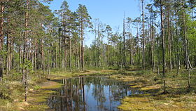 Lauhanvuori National Park, forest swamp | |
| IUCN Category II ( National Park ) | |
| basic information | |
| Square | 53 km² |
| Established | 1982 year |
| Attendance | 10000 ( 2009 [1] ) |
| Management organization | Main Forestry Administration of Finland ( Fin. Metsähallitus ) |
| Location | |
| A country |
|
| Nearest town | Vaasa |
outdoors.fi/lauhanvuorinp | |

Content
History
At the end of the ice age 9.3 thousand years ago, mainland ice moved away from the Lauhanvuori region, and the top of the mountain became the island of Antsilovoye Lake . The peak at that time was at an altitude of 203 meters above the coastline. The earth quickly rose over the next thousand years, and coastal shafts formed on its slopes. Lauhanvuori was a desert region until the 17th century. Gradually, rural settlements appeared in the vicinity of Lauhanvuori, and locals began to hunt in the area. In the historical period, the forests of Lauhanvuori were used for different purposes. In the XVIII and XIX centuries, resin cultivation actively developed. The resin was transported for sale to Kristiinankaupunki on the road through Lauhanvuori. In the 19th century, potatoes were grown on the slopes of the mountains, grazed cattle and celebrated Johannus.
In 1973, the deliberative commission on environmental protection made a proposal to establish a national park in Lauhanvuori, which was opened in 1982. At the beginning, the park’s area was only 2600 hectares, but in 1993, the Mayaletto, Nokilammennev districts, the so-called Northern Lauha district, as well as the adjacent purchased territories were annexed to the park. As a result, the area of the national park increased to 53 km².
Nature
This heavily boggy flat area, located 60 km from the coast of the Gulf of Bothnia, was formed in the Holocene period after the retreat of the last glacier. But the central part of the park is a mountain of Lauhanvuori, built of sandstones, which is rare for Finland. At the top of the mountain there is an observation tower [2] .
Mount
The height of Lauhanvuori Mountain is 231 m, it is one of the highest points in Western Finland, which allows us to call this area “Lapland of Western Finland”. [3] After the retreat of the glacier, this peak was not covered by water, representing one of the islands of Lake Antsilov [4] .
Vegetation and fauna
Since Mount Lauhanvuori, unlike its surroundings, was not the bottom of the sea, sediment and soil did not form on it. Its slopes are treeless and barren. The birds of the national park are represented by such northern species as finches and waxwings. Representatives of rare species of both higher plants and mosses, as well as lichens, grow in the marshes. The oldest pine trees are over 125 years old. The national park is the southernmost habitat of the tiny Tofieldia ( Tofieldia pusilla ). [five]
Attractions
The park's list of attractions includes Kiviyata, Aumakivi and the observation tower. Kiviyata - an ancient coastal rampart from sandstone rare for Finland. Aumakivi is a large portable boulder located on the lower shaft. In 2004, an observation tower was built on top of the mountain.
Leisure activities
Lauhavuori National Park is suitable for day trips. The park has about ten kilometers of marked hiking trails. Hiking routes are divided into seven sections. All routes are light or medium. In summer, guides work in the park. In winter, cross-country skiing is possible on the ski runs laid by the municipalities of Kauhajoki and Isojoki . Leadership and customer service are organized by the Muuraheinen Nature Tourism Center and the Seitseminen Nature Center. In summer, a cafe is located in the nature tourist center.
See also
- List of national parks in Finland
Notes
- ↑ Käyntimäärät kansallispuistoittain 2009 (fin.) (Neopr.) ? . Metsähallitus . Date of treatment September 29, 2010. Archived on October 5, 2012.
- ↑ VisitFinland - Detail - The Official Travel and Tourism Portal of Finnish Tourist Board
- ↑ Ymparisto> Lauhanvuori
- ↑ Lauhanvuoren luonto unopened (inaccessible link) . Metsähallitus. Date of treatment October 26, 2008. Archived on October 7, 2006.
- ↑ Heikkilä, Raimo Kauhajoen suot vuonna 1999 . Kauhajoen metsien ja soiden kirja 154. Date accessed November 4, 2008. Archived September 16, 2012.