The Chitino-Ingodinsky Depression is a depression in the western part of the Trans-Baikal Territory of Russia , one of the largest (in length).
| Chitino-Ingodinsky Depression | |
|---|---|
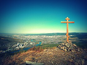 View of the hollow from the nameless hill 1045 m south of Chita | |
| Specifications | |
| Type of | intermountain |
| Depth | up to 400 m |
| Length | 260 km |
| Width | up to 25 km |
| Location | |
| A country |
|
| The subject of the Russian Federation | Transbaikal region |
| Mountain system | Highlands |
| Between the ridges | Apple ridge , Chersky ridge |

Location
The Chitino-Ingodinsky Depression is located between the Yablonovy Range (from the north and north-west) and Chersky (from the south and southeast). The depression consists of two parts: Ingodinsky (over 190 km long) and Chita (over 70 km), which are connected in the vicinity of the city of Chita , thus having a total length of over 260 km. The width of the depression varies from 2-4 to 25 km. The depression begins in the southwest, from the villages of Novosaliya and Shebartui 2nd and ends in the northeast with the valley of the Sakhaltukan River (the right tributary of Chita ).
Geology
The Chitino-Ingodinsky Depression is composed of sedimentary (with brown coal deposits) granitoid and basaltoid formations of the Upper Jurassic-Lower Cretaceous age, overlain by Cenozoic continental sediments of relatively low thickness. The foundation of the cavity belongs to the Mesozoic ; further formation went to Neogene - Quaternary .
The bottoms of both parts of the depression are most elevated on the flanks (750–900 m) and gradually decrease to the junction to 637 m. The sides of the depression (slopes of the surrounding ridges) are mostly gentle. The main types of landscape are riverine meadows , forest-steppes (often plowed), pine forests that pass up the slopes to the mountain taiga .
Sources
- Chitino-Ingodinsky Depression . ez.chita.ru . The project " Encyclopedia of Transbaikalia ." Date of treatment January 19, 2019. Archived September 24, 2018.