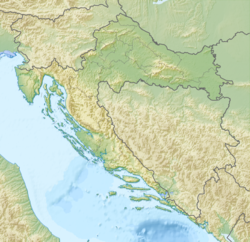
Tsetina ( Croat. Cetina ) - a river in Croatia . Length - 105 km. It falls into the Adriatic Sea .
| Cetina | |
|---|---|
| Horv. Cetina | |
 | |
| Characteristic | |
| Length | 105 km |
| Pool | 3700 km² |
| Watercourse | |
| Source | |
| • Location | Dinar Highlands |
| • Height | 385 m |
| • Coordinates | |
| Mouth | Adriatic Sea |
| • Height | 0 m |
| • Coordinates | |
| Location | |
| A country |
|
| Regions | Sibensko-Kninska , Splitsko-Dalmatinsk |
The river is famous for its picturesque gorge with a rapid flow.
The cities of Trilj and Omiš are located on Cetinje.
The river begins seven kilometers from the small village of Cetina on the slopes of the Dinar Highlands at an altitude of 385 meters above sea level near the border of Bosnia and Herzegovina . 20 kilometers from the source on the river, a large reservoir of Peruca is formed , also called Peručko jezero. The length of the reservoir is about 18 kilometers.
Upon exiting the reservoir, the river flows southeast, flowing the city of Tril and several villages. The flow rate is very high, several small hydroelectric power stations have been built on this site on the river. During archaeological excavations along the banks of Cetina, important discoveries were discovered from the Early Neolithic to the Early Bronze Age (Cetin culture). Also on the banks of the river are the remains of several Roman fortresses that covered the entrance to the strategically important Cetin gorge.
Near the village of Zadvarye, the river sharply turns south-west and begins to make its way through a continuous mountain range, separating from the continent a narrow strip of the southern Adriatic coast, forming the famous Cetin gorge. The gorge is one of the rare routes connecting the southern coast with the rest of the country, and the most convenient among them, which from ancient times has made it a strategically important trade and military route. To the north of the gorge is the Mosor Ridge, and to the south is the Biokovo Ridge.

The river flows in the canyon very quickly, forming numerous rapids and waterfalls. The largest waterfall - Velika Gubavitsa (48 m) is located in the upper part of the gorge. Picturesque landscapes, views of the rocky walls of the gorge and waterfalls attract many tourists here. Cetina is one of the most popular rafting spots in Croatia. In the Cetin gorge, the DEFA film studio ( GDR ) made some films from its famous cycle about Indians .
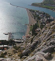
At the confluence of the river in the Adriatic Sea is the city of Omis . Mirabella fortress rises in the city. On the mountain above the city are the remains of the Stari Grad fortress, which controlled the exit from the Cetina gorge.