Kalininsky district is an administrative-territorial unit ( district ) and a municipality ( municipal district ) in the Saratov region of Russia .
| Municipal district | |||||
| Kalininsky district | |||||
|---|---|---|---|---|---|
| |||||
| A country | |||||
| Enters into | Saratov region | ||||
| Includes | 13 municipalities | ||||
| Adm Centre | Kalininsk city | ||||
| Head of Municipal District | Kovalsky Roman Stanislavovich [1] | ||||
| Head of District Administration | Alekseev Dmitry Anatolyevich [1] | ||||
| History and geography | |||||
| Date of education | July 23, 1928 | ||||
| Square | 3200 km² | ||||
| Timezone | MSK + 1 ( UTC + 4 ) | ||||
| Population | |||||
| Population | ↘ 30 502 [2] people ( 2018 ) (1.25%) | ||||
| Density | 9.53 people / km² | ||||
| Digital identifiers | |||||
| Telephone code | 84549 | ||||
| OKATO | 63,221,000,000 | ||||
| Official site | |||||
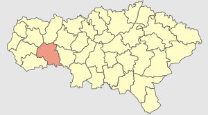 | |||||

The administrative center is the city of Kalininsk .
Content
Geography
The district is located on the south of the Right Bank, on the western spurs of the Volga Upland in the Ursa River basin.
The length of public roads with hard surface is 394.7 km.
History
The district was formed on July 23, 1928 under the name Balandinsky as part of the Saratov district of the Nizhne-Volzhsky Krai .
Since 1934, the district is part of the Saratov region , since 1936 - in the Saratov region .
On September 30, 1958, the territory of the abolished Kazachkinsk District became part of the district .
On May 19, 1960, the territory of the abolished Sverdlovsk District was included in the district .
In 1962, the settlement of Balanda was transformed into the city of Kalininsk , and the district was renamed Kalininsky [3] .
On January 1, 2005, the Kalininsky municipal district was formed as a municipality [4] .
Population
| Population | ||||||
|---|---|---|---|---|---|---|
| 1989 [5] | 2002 [6] | 2009 [7] | 2010 [5] | 2011 [8] | 2012 [9] | 2013 [10] |
| 39 603 | ↗ 39,732 | ↘ 38,234 | ↘ 33,302 | ↘ 33,214 | 85 32,854 | ↘ 32,402 |
| 2014 [11] | 2015 [12] | 2016 [13] | 2017 [14] | 2018 [2] | ||
| ↘ 31,984 | ↘ 31,645 | ↘ 31,271 | ↘ 30,964 | ↘ 30 502 | ||
- Urbanization
51.87% of the district’s population live in urban conditions ( Kalininsk city).
- National composition
According to the census of 1939 : Russians - 68.2% or 22,726 people, Ukrainians - 30% or 9980 people [15] .
National composition according to the 2010 census [16] : Russians - 28,223 people. Ukrainians - 1 670 people. Armenians - 518 people Tatars - 293 people. Kazakhs - 269 people Chechens - 230 people. others - 1 615 people
Municipal unit
The Kalininsky municipal district includes 11 municipalities , including 1 urban settlement and 10 rural settlements [17] [18] :
| No | Municipality | Administrative center | amount inhabited points | Population | Square, km 2 |
|---|---|---|---|---|---|
| City settlement: | |||||
| one | municipality Kalininsk city | Kalininsk city | one | ↘ 15,821 [2] | |
| Rural settlements: | |||||
| 2 | Akhtubinsky municipality | Akhtuba village | 14 | ↘ 1870 [2] | |
| 3 | Kazachkino municipality | Kazachka village | five | ↘ 2024 [2] | |
| four | Kolokoltsovo municipality | Kolokoltsovka village | one | ↘ 978 [2] | |
| five | Malokaterinovo municipality | the village of Malaya Ekaterinovka | four | ↘ 1233 [2] | |
| 6 | Ozersk municipality | Ozerki village | 6 | ↘ 1626 [2] | |
| 7 | Sverdlovsk municipality | Sverdlovo village | 6 | ↘ 1145 [2] | |
| eight | Sergievsky municipality | Sergievka village | 3 | ↘ 1385 [2] | |
| 9 | Simonovo municipality | Simonovka village | ten | ↘ 2415 [2] | |
| ten | Talovsk municipality | Talovka village | eight | ↘ 1073 [2] | |
| eleven | Shirokokoustopsky municipality | Broad Led Village | five | ↘ 932 [2] |
Locations
In Kalininsky district there are 63 settlements.
| List of settlements of the district | ||||
|---|---|---|---|---|
| No | Locality | Type of | Population | Municipal education |
| one | Alexandrovka 3rd | village | 689 [5] | Akhtubinskoe |
| 2 | Alekseyevka | village | 0 [5] | Simonovskoe |
| 3 | Alekseevsky | village | 2 [5] | Akhtubinskoe |
| four | Anastasino | village | 515 [5] | Shirokokoupskoe |
| five | Akhtuba | village | 639 [5] | Akhtubinskoe |
| 6 | White Keys | village | 84 [5] | Akhtubinskoe |
| 7 | Birch | farm | 21 [5] | Talovskoe |
| eight | Bogatovka | village | 99 [5] | Akhtubinskoe |
| 9 | Big Olshanka | village | 543 [5] | Malokaterinovskoe |
| ten | Big Turks | village | 0 [5] | Talovskoe |
| eleven | Varvarina Nut | village | 35 [5] | Simonovskoe |
| 12 | Vasilyevsky | village | 104 [5] | Ozerskoe |
| 13 | Vladykino | village | 36 [5] | Sverdlovsk |
| 14 | Dubravny | village | 153 [5] | Simonovskoe |
| 15 | Ekaterinovsky | village | 42 [5] | Akhtubinskoe |
| sixteen | Cossack | village | 1709 [5] | Kazachkinskoye |
| 17 | Kalininsk | city | ↘ 15,821 [2] | Kalininsk city |
| 18 | Stone | village | 103 [5] | Kazachkinskoye |
| nineteen | Kim | village | 121 [5] | Akhtubinskoe |
| 20 | Maple Tops | village | 0 [5] | Sverdlovsk |
| 21 | Kologreevka | village | 156 [5] | Simonovskoe |
| 22 | Bell ring | village | ↘ 978 [2] | Kolokoltsovskoe |
| 23 | Kochetov | village | 46 [5] | Shirokokoupskoe |
| 24 | Krasnoarmeyskoe | village | 281 [5] | Sverdlovsk |
| 25 | Round | farm | 172 [5] | Malokaterinovskoe |
| 26 | Cool | village | 0 [5] | Akhtubinskoe |
| 27 | Winch | village | 94 [5] | Ozerskoe |
| 28 | Malaya Ekaterinovka | village | 516 [5] | Malokaterinovskoe |
| 29 | Mikhaylovka | village | 309 [5] | Talovskoe |
| thirty | Monastic | village | 303 [5] | Simonovskoe |
| 31 | Nizhegorody | village | 258 [5] | Ozerskoe |
| 32 | Nikolaevka | village | 101 [5] | Talovskoe |
| 33 | Nikolaevka | village | 71 [5] | Talovskoe |
| 34 | New Ivanovka | village | 492 [5] | Simonovskoe |
| 35 | Novoaleksandrovka | village | 73 [5] | Sverdlovsk |
| 36 | Novoteplovka | village | 137 [5] | Sergievskoe |
| 37 | New Vyselki | village | 682 [5] | Sergievskoe |
| 38 | Lakes | village | 688 [5] | Ozerskoe |
| 39 | Orlovka | village | 280 [5] | Talovskoe |
| 40 | Pantyrovka | village | 78 [5] | Simonovskoe |
| 41 | May Day | village | 522 [5] | Simonovskoe |
| 42 | Sandy | village | 214 [5] | Ozerskoe |
| 43 | Radushinka | village | 124 [5] | Akhtubinskoe |
| 44 | Rodnichki | village | 3 [5] | Kazachkinskoye |
| 45 | Saltykovo | village | 239 [5] | Simonovskoe |
| 46 | Sverdlovo | village | ↘ 552 [5] | Sverdlovsk |
| 47 | Sergievka | village | 687 [5] | Sergievskoe |
| 48 | Simonovka | village | 710 [5] | Simonovskoe |
| 49 | Slavnovka | village | 293 [5] | Akhtubinskoe |
| 50 | Oweno | village | 21 [5] | Akhtubinskoe |
| 51 | Consonant | village | 128 [5] | Ozerskoe |
| 52 | Sofyinka | village | 8 [5] | Shirokokoupskoe |
| 53 | Old Ivanovka | village | 6 [5] | Shirokokoupskoe |
| 54 | Steppe | village | 500 [5] | Kazachkinskoye |
| 55 | Talovka | village | 392 [5] | Talovskoe |
| 56 | Fedorovka | village | 176 [5] | Malokaterinovskoe |
| 57 | Chikhachevka | village | 6 [5] | Kazachkinskoye |
| 58 | Shalinka | village | 64 [5] | Akhtubinskoe |
| 59 | Wide ledge | village | 601 [5] | Shirokokoupskoe |
| 60 | Shklovo | village | 360 [5] | Sverdlovsk |
| 61 | Fur coat | village | 17 [5] | Akhtubinskoe |
| 62 | Shumakovka | village | 115 [5] | Talovskoe |
| 63 | Yasnaya Polyana | village | 74 [5] | Akhtubinskoe |
Economy
Agriculture specializes in the production of grain, sunflower , livestock products, poultry. The main plants: brewing.
In the area there are sports, art and 1 music school. There are 8 folk art groups.
Attractions
Monuments of nature of regional significance:
PAs Pervomayskoe Quarry (Bezobrazka) , 1 km northeast of the village. May Day. In the quarry, the most complete section of the Cenomanian sediments in the right bank of the Volga region was opened. More than 50 types of fossil forms have been found and identified here: bivalves and shovel-legged mollusks, ammonites, rostra of belemnites, sponge skeletons, chimeric and bony fish, shark teeth, teeth and bones of vertebrates. Most fossil residues are confined to phosphate horizons.
Hygrophytes refugium in the valley of the r. Balanda , 1 km from the northwestern outskirts of Kalininsk. Created to save a vast wet meadow, rolling in the grassy lowland swamp on the upper floodplain. Balanda The bog does not dry up in the hottest and driest years. A very rare natural complex for a typical steppe of the Saratov Right Bank. Refuge for many hygrophytes.
Not far from the highway to Voronezh there is a Peschansky sanatorium: a park with coniferous and deciduous trees, local mineral water, koumiss and a microclimate favorable for the treatment of respiratory organs.
Literature
- Atlas of highways of the Saratov region. Saratov, 2000.
Notes
- ↑ 1 2 List of heads and heads of administrations of municipal districts of the region (inaccessible link)
- ↑ 1 2 3 4 5 6 7 8 9 10 11 12 13 14 15 Population of the Russian Federation by municipalities as of January 1, 2018 . The appeal date was July 25, 2018. Archived July 26, 2018.
- ↑ Saratov region on the site “World Historical Project” Archived December 3, 2010.
- ↑ Law of the Saratov region of December 23, 2004 No. 78-ZSO "On municipal districts"
- ↑ 1 2 3 4 5 6 7 8 9 10 11 12 13 14 15 16 17 18 19 20 21 22 23 24 25 26 27 28 28 30 31 33 33 35 35 37 38 39 40 41 42 43 44 45 46 47 48 49 50 51 52 53 54 55 56 57 58 59 60 61 62 63 All-Russian Population Census 2010. The number and location of the population of the Saratov region . The appeal date was July 6, 2014. Archived July 6, 2014.
- ↑ All-Russian census of 2002. Tom. 1, table 4. The population of Russia, federal districts, constituent entities of the Russian Federation, districts, urban settlements, rural settlements — regional centers and rural settlements with a population of 3,000 or more . Archived on February 3, 2012.
- ↑ The resident population of the Russian Federation by cities, urban-type settlements and districts as of January 1, 2009 . The date of circulation is January 2, 2014. Archived January 2, 2014.
- ↑ Saratov region. Estimate of the number of resident population on January 1, 2009-2015
- Population of the Russian Federation by municipalities. Table 35. Estimated number of resident population on January 1, 2012 . The date of circulation is May 31, 2014. Archived May 31, 2014.
- ↑ Population of the Russian Federation by municipalities as of January 1, 2013. - M .: Federal State Statistics Service Rosstat, 2013. - 528 p. (Table 33. Population of urban districts, municipal districts, urban and rural settlements, urban settlements, rural settlements) . The appeal date is November 16, 2013. Archived November 16, 2013.
- ↑ Table 33. The population of the Russian Federation by municipalities as of January 1, 2014 . Circulation date August 2, 2014. Archived August 2, 2014.
- ↑ Population of the Russian Federation by municipalities as of January 1, 2015 . Circulation date August 6, 2015. Archived August 6, 2015.
- Population of the Russian Federation by municipalities as of January 1, 2016
- ↑ Population of the Russian Federation by municipalities as of January 1, 2017 (July 31, 2017). The date of circulation is July 31, 2017. Archived July 31, 2017.
- All-Union census of 1939. The national composition of the population of the districts, cities and large villages of the RSFSR . Demoscope Circulation date August 6, 2017. Archived August 6, 2017.
- ↑ srtv.gks.ru
- ↑ Law of the Saratov region of December 27, 2004 No. 94-ZSO "On municipalities belonging to the Kalininsky municipal district"
- ↑ Charter of Kalininsky municipal district (inaccessible link)
See also
- Administrative division of the Saratov region
- Settlements of the Saratov region
- Coats of arms of the Saratov region