Bypass channel (Admiralteysky, Wired) - channel in Kronstadt . It originates from the Italian pond and ends in the harbor of Kronstadt. It runs along the Admiralty and the streets: Karl Marx , Sovetskaya , Komsomol and Petrovskaya . Ends on the territory of the Marine Plant . Bridges: Blue , Soviet, Sailing and Hemp. It is a historical monument; a lattice along the canal is a historical monument.
| Bypass channel | |||
|---|---|---|---|
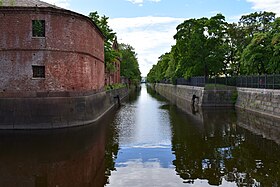 Left - Admiralty, on the right is Catherine Park | |||
| Location | |||
| A country |
| ||
| The subject of the Russian Federation | St. Petersburg | ||
| Characteristic | |||
| Length | 3 km | ||
| Watercourse | |||
| Head | Italian palace | ||
| · Head location | Kronstadt footstock | ||
| Head height | 0 m | ||
| Mouth | The Gulf of Finland | ||
| · Location of the mouth | Forest harbor | ||
| · The height of the mouth | 0 m | ||
| |||
Content
History
Originally created for the needs of the Admiralty being transferred to Kronstadt, therefore it was called the Admiralty. After, following the example of the St. Petersburg Obvodny Canal , it received a modern name.
All bridges across the Obvodny Canal were bypasses, but with the advent of road transport they were replaced by conventional ones. Thus, only one drawbridge remained in Kronstadt - Dokovy , which is thrown over the canal of the Petrovsky Dock.
The channel is widened at bends - this is done so that the oncoming vessels can disperse.
In 2005, on the western wall of the Obvodny Canal, near the Blue Bridge, a monument to the blockade stickleback - a fish was erected, thanks to which the residents of the city survived the blockade [1] .
Location
Along most of the canal, from Karl Marx Street to the Sovetsky Bridge, the Kronstadt Admiralty stretches, thus separated from one of the main streets of the city - Sovetskaya. However, in addition to the canal, Catherine Park also separates it from Sovetskaya Street.
The Anchor Square and the Italian Palace are also located next to the Obvodny Canal; the ravine of the Petrovsky Dock flows into the Obvodny Canal, where water merged when the ships were launched for repairs in the dry Petrovsky Dock.
Transport
Near the canal there are public transport routes:
Buses:
- No. 1 - along the canal along Sovetskaya Street, and along Lenin Avenue only in the opposite direction;
- No. 2 - along Sovetskaya street;
- No. 3 - near the estuary at the Marine Plant , and further along Lenin Avenue.
Notes
- ↑ "Blockade Thorn," a commemorative sign . Encyclopedia of St. Petersburg. Date of treatment April 3, 2015.
Literature
- City names today and yesterday: Petersburg toponymy / comp. S.V. Alekseeva, A.G. Vladimirovich , A.D. Erofeev et al. - 2nd ed., Revised. and add. - SPb. : Lick , 1997 .-- 288 p. - (Three centuries of Northern Palmyra). - ISBN 5-86038-023-2 .
- Gorbachevich K. S. , Khablo E. P. Why are they so named? On the origin of the names of streets, squares, islands, rivers and bridges of St. Petersburg. - SPb. : Norint , 2002 .-- 353 p. - ISBN 5-7711-0019-6 .
- Architects of St. Petersburg. XX century / comp. V. G. Isachenko ; ed. Yu. Artemyev, S. Prohvatilova. - SPb. : Lenizdat , 2000 .-- 720 p. - ISBN 5-289-01928-6 .