Nomes ( prefectures ; Greek νομοί , unit part νομός ) - abolished (from January 1, 2011 according to the Kallikratis Program ) administrative units of the second level of Greece . As a result of the reforms, the nomes became peripheral units ( Greek περιφερειακές ενότητες ) as part of the peripheries (administrative regions); the borders of peripheral units basically, but not always, coincide with the borders of nomes.
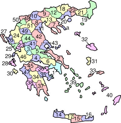

Below are listed all the nomes (prefectures) of Greece by their location in the administrative districts and according to the numbering on the map.
Content
Attica
1. Attica - on the map of prefectures (nomes) Attica is indicated under one number for easy display. In fact, it is divided into 4 nomes (nomarchies), shown on the map below:
- 1.1. Athens
- 1.2. East Attica
- 1.3. Piraeus
- 1.4. West Attica
- 1.2. East Attica
Central Greece
2. Euboea
3. Euritania
4. Phocis
5. Phthiotide
6. Boeotia
Central Macedonia
7. Halkidiki
8. Imatia
9. Kilkis
10. Pella
11. Pieria
12. Serre
13. Thessaloniki
Crete
14. Chania
15. Heraklion
16. Lasithi
17. Rethymnon
East Macedonia and Thrace
18. Drama
19. Evros
20. Kavala
21. Rhodope
22. Xanthi
Epirus
23. Arta
24. Ioannina
25. Preveza
26. Thesprotia
The Ionian Islands
27. Kerkyra (Corfu)
28. Kefalonia
29. Lefkada
30. Zakynthos
North Aegean Islands
31. Chios
32. Lesbos
33. Samos
Peloponnese
34. Arcadia
35. Argolis
36. Corinthia
37. Laconia
38. Messinia
South Aegean Islands
39. Cyclades
40. Dodecanese
Thessaly
41. Karditsa
42. Larisa
43. Magnesia
44. Trikala
Western Greece
45. Achaea
46. Aetolia and Acarnania
47. Elijah
Western Macedonia
48. Florina
49. Grevena
50. Kastoria
51. Kozani
Athos
Autonomous region on the map is marked with the symbol " a "