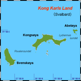
Abeløya [2] [3] ( Norwegian Abeløya ) (Abela Island) - One of 5 islands (the third largest), a group of islands of King Charles Land , the Spitsbergen archipelago (integrated overseas territory of Norway ) in the Arctic Ocean , in the Barents Sea with an area of 13.2 km². The uninhabited island, together with other islands of the group, is part of the Nordaust-Svalbard nature reserve, landing on the island is strictly prohibited. It makes up 3.98% of the territory of the King Charles Island group of islands and 0.02% of the territory of the Svalbard archipelago. Located 12.5 km. east of about. Kongseya (the main island of King Charles Land), which shares the Strait of Lyannianasun , is also the closest island and land to it. The island got its name in honor of the Norwegian mathematician Abel . In August 1930, the ship " Bratvag " visited the island; crew members noted that the island consists of "low basalt rocks." [four]
| Abeloya | |
|---|---|
| Norwegian Abeløya | |
 island in the northeast | |
| Specifications | |
| Square | 13.2 [1] km² |
| Population | 0 pax (2012) |
| Location | |
| Archipelago | Svalbard |
| Water area | Barents Sea |
| A country |
|
| Territory | Svalbard |
Remoteness of the island from the main geographical points and objects of civilization
Remoteness west of other islands of his group (King Charles Land): about. Svenskoya - 72 km .; about. Helgolandoya - 37 km .; about. Tirpitsoya - 39.5 km.
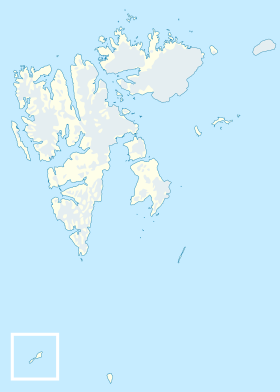
The nearest island of the Svalbard archipelago is not included in the group of islands of the King Charles Land Northeastern Land (metro Mon), is 99 km away. to sv., which shares the Eric Eriksen Strait.
The nearest land in the north of. Bely ( metro Andre ), located at a distance of 116.5 km. to North.
The nearest land in the south of. Nadezhda ( metro Beisaren ), located 274 km. to the south. On it is the nearest settlement (weather station Hopen radio ).
Nearest inhabited island: about. Western Svalbard ( metro Payer ), is located 184 km. west.
Nearest village (with port and airport): Sveagruva settlement (working village), located 321 km. to the west on the island of Western Svalbard.
Nearest town: Longyearbyen (the capital of Svalbard), located 327 km. to the west on the island of Western Svalbard.
The nearest neighboring Archipelago , as well as the territory of a foreign state: Franz Josef Land (about. Alexandra Land , Russia ), is located 334 km. to St.
The nearest mainland and part of the world: Eurasia ( Europe (Norwegian coast)), is located 874.5 km to the south.
Property in the distance to the capital of Norway ( Oslo ): 2217 km. to the south.
See also
- King Charles Land
- List of islands of Svalbard archipelago
Notes
- ↑ Abeløya (Svalbard) . Norwegian Polar Institute . Date of treatment July 10, 2013.
- ↑ Norway, Sweden, Finland // Atlas of the World / comp. and preparation. to the ed. PKO "Cartography" in 2009; ch. ed. G.V. Pozdnyak . - M .: PKO "Cartography": Onyx, 2010. - S. 50-51. - ISBN 978-5-85120-295-7 (Cartography). - ISBN 978-5-488-02609-4 (Onyx).
- ↑ Abeloya // Dictionary of geographical names of foreign countries / resp. ed. A.M. Komkov . - 3rd ed., Revised. and add. - M .: Nedra , 1986.- S. 7.
- ↑ Wings over the Pole, Umberto Nobile (Unavailable link) . Archived August 1, 2012.